
 United Kingdom
 France
 Germany
 Netherlands
 Sweden
 USA
USA
 Italy
Italy
 Spain
Spain
More From Contributor

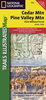


Cederberg Mountains Hiking Set (2-map Set)
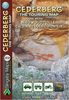
Cederberg Mountains in the Western Cape Province on a set of two double-sided, waterproof and tear-resistant, GPS compatible hiking maps at 1:40, 000 from Slingsby Maps, providing a vivid picture of the topography with hiking trails and detailed road network, tourist facilities and places of interest, etc. The set shows the Cederberg mountain range, complementing the publishers’ wider coverage of the Cederberg region on a touring map at 1:160, 000. Contours at 20m intervals, enhanced by relief shading, altitude colouring, plus colouring and/or graphics for different types of terrain and vegetation, provide an excellent representation of the topography. Various ranges, peaks and passes are named and lots of additional spot heights are marked. An overprint highlights various
hiking trails, indicating head trails, permit requirements, waymarking for special routes, etc. Also marked are tracks and footpaths not recommended for hikers. Road network indicates untarred roads, 4WD routes or roads requiring high clearance, private roads where owners’ permission may be required, etc. Important junctions and other locations are annotated with GPS waypoints. Symbols indicate various facilities and places of interest including various types of tourist accommodation (lodges, guest houses, B&Bs, campsites, etc), restaurants, picnic places, local arts and crafts shops, petrol stations, wineries, sport and recreational facilities, etc. In addition to the GPS waypoints the maps have a latitude and longitude grid at intervals of 1’. The maps were
researched and drawn by Peter Slingsby - renowned environmental educator and cartographer. To see other titles in this series please click on the series link.
 "Pin It")
Product Description
Reviews/Comments
Add New
Vouchers
No voucher codes found.
Do you know a voucher code for this product or supplier? Add it to Insights for others to use.
Do you know a voucher code for this product or supplier? Add it to Insights for others to use.
 Denmark