
 United Kingdom
 France
 Germany
 Netherlands
 Sweden
 USA
USA
 Italy
Italy
 Spain
Spain
More From Contributor


British Columbia
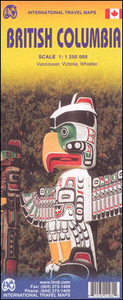
British Columbia at 1:1, 250, 000 on an indexed double-sided map from ITMB, with street plans of central Vancouver and Victoria and coverage extending acrss to Calgary to include the Rocky Mountains with Banff and Jasper National Parks.The province is divided north/south with a good overlap between the sides. Topography is presented by altitude colouring, with elevation and spot heights given in feet. National and provincial parks and forests are highlighted. The map shows the road network indicating gravel roads and tracks, with driving distances given on main routes and locations of petrol stations marked in more remote areas, particularly in the northern part of the province.Railway lines and ferry routes are included and local airports are indicated. A range of symbols highlight
tourist information offices, camping and RV sites, recreational areas, and other places of tourist interest. The map has a latitude and longitude grid at intervals of 1
tourist information offices, camping and RV sites, recreational areas, and other places of tourist interest. The map has a latitude and longitude grid at intervals of 1
Product Description
Reviews/Comments
Add New
Intelligent Comparison
Archived Product
British Columbia ITMB Stanfords
£9.99
Archived Product
British Columbia MapArt Stanfords
£8.99
Archived Product

British Columbia FastTrack Stanfords
£10.99
Archived Product

British Columbia South ITMB Stanfords
£9.99
Vouchers
No voucher codes found.
Do you know a voucher code for this product or supplier? Add it to Insights for others to use.
Do you know a voucher code for this product or supplier? Add it to Insights for others to use.
 Denmark