
 United Kingdom
 France
 Germany
 Netherlands
 Sweden
 USA
USA
 Italy
Italy
 Spain
Spain
More From Contributor


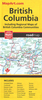


British Columbia South ITMB
Indexed double-sided road map at 1:800, 000 from ITMB of the southern part of British Columbia, extending from Vancouver Island to Calgary to cover the whole of the Banff and Jasper National Parks, with plans of downtown Vancouver and Victoria. Coverage northwards extends to include the southern part of Haida Gwai (Queen Charlotte) Islands and Prince Rupert along the coast, as well as Fort St. John near the border with Alberta.The map has altitude colouring, indicates national parks and other protected areas, and highlights numerous camping areas and recreational facilities. Road network includes paved and rough roads and 4WD tracks, and indicates locations of petrol stations. Latitude and longitude lines are drawn at intervals of 1º. Each side has a separate index. Also included
are insets with street plans of downtown Vancouver (1:12, 500) and Victoria (1:20.000), highlighting selected accommodation and various facilities.To see other titles in this series please click on the series link.
are insets with street plans of downtown Vancouver (1:12, 500) and Victoria (1:20.000), highlighting selected accommodation and various facilities.To see other titles in this series please click on the series link.

Product Description
Reviews/Comments
Add New
Vouchers
No voucher codes found.
Do you know a voucher code for this product or supplier? Add it to Insights for others to use.
Do you know a voucher code for this product or supplier? Add it to Insights for others to use.
 Denmark