More From Contributor

£9.99
Indexed double-sided road map at 1:800, 000 from ITMB of the southern part of British Columbia, extending from Vancouver Island to Calgary to cover the whole of the Banff & Jasper National Parks, with plans of downtown Vancouver & Victoria. Coverage northwards extends to include the southern part of Haida Gwai (Queen Charlotte) Islands & Prince Rupert along the coast, as well as Fort St. John near the border with Alberta. The map has altitude colouring, indicates national parks & other protected areas, & highlights numerous camping areas & recreational facilities. Road network

Includes::
paved & rough roads & 4WD tracks, & indicates locations of petrol stations. Latitude & longitude lines are drawn at intervals of 1º. Each side has a separate index. Also included are insets with street plans of downtown Vancouver (1:12, 500) & Victoria (1:20.000), highlighting selected accommodation & various facilities. To see other titles in this series please click on the series link.

...
Archived Product
£8.95
Indexed double-sided road map of the southern part of British Columbia, extending from Vancouver Island to Calgary to cover the whole of the Banff & Jasper National Parks, with plans of downtown Vancouver & Victoria. Coverage northwards extends to include the southern part of Haida Gwai Island & Prince Rupert along the coast, as well as Fort St. John near the border with Alberta. The map has altitude colouring, indicates national parks & other protected areas, & highlights numerous camping areas & recreational facilities. Road network

Includes::
paved & rough roads & 4WD tracks, & indicates locations of petrol stations. The map is indexed & has latitude & longitude lines at intervals of 1

...
Archived Product
£8.95
Indexed double-sided road map at 1:900, 000 from ITMB of the southern part of British Columbia, extending from Vancouver Island to Calgary to cover the whole of the Banff & Jasper National Parks, with plans of downtown Vancouver & Victoria. Coverage northwards extends to include the southern part of Haida Gwai Island & Prince Rupert along the coast, as well as Fort St. John near the border with Alberta. The map has altitude colouring, indicates national parks & other protected areas, & highlights numerous camping areas & recreational facilities. Road network

Includes::
paved & rough roads & 4WD tracks, & indicates locations of petrol stations. The map is indexed & has latitude & longitude lines at intervals of 1

...
Archived Product
£40.00
British Embassies have a special role in our history. They represent our country in bricks & stone & have often expressed
- at
...
Archived Product
£45.00
Old map of the British Empire, first published circa 1895, republished 2018. British possessions are documented in red. Steamer routes, sailing vessels, railways, prinicpal exports, & telegraph cables are all detailed as the key. Inset maps of Russian & Dutch possessions, & German & French possessions. This reproduction was taken from what used to be called a “cloth-dissected” map, made when the map itself was cut into sections & each section then individually pasted onto an overall cloth backing for the whole map. In this version the whole map is backed onto cloth in one piece but the gaps between the sections have been reproduced in the printing to preserve the style & the feeling of the original. Each individual map is presented folded in a colourful case covered with a unique design marbled paper – no two cases are identical.PLEASE NOTE: this title is also available in a larger size reproduction. To see the list of all the titles in this series from Old Folding Maps please click on the series link. ...
Archived Product
£6.99
With the end of the Second World War it was not long before increasing wealth, cheaper cars, & social pressures made a family car the aspiration of thousands. Ford, Hillman, Standard, Morris & Vauxhall became household names, & the streets of Britain`s suburbs began to fill with modern-looking saloon cars, designed to transport mother, father & 2.4 children with ease, if not speed. This highly-illustrated book looks at the British cars that were available to the post-war family, & also some of the foreign makes that had an important place in the market, & which had a great influence on the British-made cars that followed. ...
Archived Product
£8.99
The British film industry was already well established when Hollywood sprang to life in 1911, & has remained at the forefront of film-making ever since; from Cecil Hepworth & Alfred Hitchcock to Ridley Scott & Christopher Nolan, & all the innumerable artistic & technical titans in between, the UK has never been far from the cinematic vanguard. Originally flat theatrical sets on temporary stages (often in gardens!), early British studios could be found everywhere from Glasgow to Brighton, & by the 1920s elaborately lit indoor production stages had developed. Stiff competition from the `big five` US studios led to seismic upheavals over the coming decades, yet names like Alexander Korda, Carol Reed, David Lean & Richard Attenborough attest to Britain`s enduring stature. From quintessentially British studios & productions
- Gainsborough romances, Ealing comedies, Hammer horrors & many more
- to the British role in blockbusting franchises like James Bond, Star Wars & Harry Potter, Kiri Bloom Walden here tells the century-long story of British film, illustrating it with colourful photographs of actors, directors & production staff at work.

...
Archived Product
£15.99
From the wonderfully rustic to the wildly luxurious, from The Highlands to St Ives, we`ve taken the hard work out of finding ...
Archived Product
£15.99
From the wonderfully rustic to the wildly luxurious, from The Highlands to St Ives, we`ve taken the hard work out of finding ...
Archived Product
£14.99
From sleepy inns with rooms to manor-house hotels for fabulous occasions, each of our places combines character with comfort & a big welcome. A weekend break in a historic city, a night away on business, a family holiday by the sea
- there's something for everyone here. You'll eat well, too: Michelin stars sprinkle themselves throughout this 12th edition, & there are plenty of chefs who put provenance & seasonality at the top of their list. We are committed to the small hotels of Britain, run by enterprising people who do what they do best. We look for what we like, & we celebrate the beautiful & the unusual. It is the combination of fresh, honest write-ups, colour photographs, clear symbols, excellent maps, clear directions & quick reference indices that makes our guides so popular with readers
- & helps put British Hotels & Inns at the top of the best-seller list.

...
Archived Product

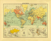
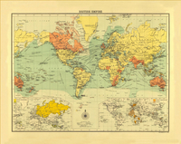
British Empire C.1895 SMALL

Old map of the British Empire, first published circa 1895, republished 2018. British possessions are documented in red. Steamer routes, sailing vessels, railways, prinicpal exports, and telegraph cables are all detailed as the key. Inset maps of Russian and Dutch possessions, and German and French possessions.This reproduction was taken from what used to be called a “cloth-dissected” map, made when the map itself was cut into sections and each section then individually pasted onto an overall cloth backing for the whole map. In this version the whole map is backed onto cloth in one piece but the gaps between the sections have been reproduced in the printing to preserve the style and the feeling of the original. Each individual map is presented folded in a colourful case covered
with a unique design marbled paper – no two cases are identical.PLEASE NOTE: this title is also available in a larger size reproduction. To see the list of all the titles in this series from Old Folding Maps please click on the series link.
RIP - This product is no longer available on our network. It was last seen on 25.09.2019

This page now acts as a permanent archive for this product. Add more information using the comments box below to ensure it can still be found by future generations.

Use our search facility to see if it is available from an alternative contributor.
  • External links may include paid for promotion
  • Availability: Out Of Stock
  • Supplier: Stanfords
  • SKU: 9786000510831
Availability: In Stock
£20.00

Product Description

Old map of the British Empire, first published circa 1895, republished 2018. British possessions are documented in red. Steamer routes, sailing vessels, railways, prinicpal exports, & telegraph cables are all detailed as the key. Inset maps of Russian & Dutch possessions, & German & French possessions. This reproduction was taken from what used to be called a “cloth-dissected” map, made when the map itself was cut into sections & each section then individually pasted onto an overall cloth backing for the whole map. In this version the whole map is backed onto cloth in one piece but the gaps between the sections have been reproduced in the printing to preserve the style & the feeling of the original. Each individual map is presented folded in a colourful case covered with a unique design marbled paper – no two cases are identical.PLEASE NOTE: this title is also available in a larger size reproduction. To see the list of all the titles in this series from Old Folding Maps please click on the series link.

Reviews/Comments

Add New

Intelligent Comparison

Oooops!
We couldn't find anything!
Perhaps this product's unique.... Or perhaps we are still looking for comparisons!
Click to bump this page and we'll hurry up.

Price History

Vouchers

No voucher codes found.
Do you know a voucher code for this product or supplier? Add it to Insights for others to use.

Facebook

Jargon Buster

Paper - A thin sheet mainly used for writing. Available in a variety of colours. Made mainly from wood pulp.
Key - A physical or virtual device or code used for opening something
Red - One of the three primary colours
Railways - A set of tracks that have been laid for the purpose of trains to travel up and down them
Size - is the measurement of how big an object is in space.
Small - something that takes up less space than normal.
Preserve - To maintain something to its complete state
Design - A drawing or styles that shows the look and functionality of something before its made.
Steamer - A hand held steam iron to remove creases from fabrics also can be a boat powered by steam
Individual - A single separate item or person.
Reproduction - A process of making a copy of something.

Supplier Information

Stanfords
Stanfords was established in 1853 and opened their iconic Covent Garden flagship store in 1901. They have become the top retailer of maps, travel books and accessories in the UK and arguably offer the largest selection of maps and travel books worldwide. Famous names such as Captain Robert Falcon Scott, Ranulph Fiennes and Michael Palin have purchased from Stanfords. They now have a shop in Bristol and both stores together with other venues operate a calendar of events including talks, book signings and exhibitions. As a specialist map retailer, the map selection is comprehensive and includes road maps, street maps and walking maps from worldwide destinations, as well as a selection of world atlases and wall maps. Books include travel guides and travel literature. Stanfords also stock globes, from miniatures made of blue marble to magnificent floor-standing globes. The website features a selection of interesting articles on travel topics.
Page Updated: 2023-11-12 20:15:36

Community Generated Product Tags

Oh No! The productWIKI community hasn't generated any tags for this product yet!
Menu