More From Contributor

£9.99
British Canada at 150 Years: 1867-2017 explores the formation of Canada & its British Heritage. It

Includes::


...
Archived Product
£19.95
This book is a mine of useful information & practical tips. If you aspire to be a better canoe or kayak coach, this is the book for you. The book divides into three sections: Part One deals with coaching theory & fundamentals such as psychology & physiology explained in terms that make sense to a practical coach. Part Two looks at generic coaching skills that will provide useful tools whatever discipline the coach is involved in. It works its way from introducing people to canoesport right through to coaching elite athletes. Part Three looks at specific aspects of canoesport such as slalom, racing, sea kayaking, white water kayaking, open canoeing & freestyle. ...
Archived Product
£8.95
British Columbia at 1:1, 250, 000 on an indexed double-sided map from ITMB, with street plans of central Vancouver & Victoria & coverage extending acrss to Calgary to include the Rocky Mountains with Banff & Jasper National Parks. The province is divided north/south with a good overlap between the sides. Topography is presented by altitude colouring, with elevation & spot heights given in feet. National & provincial parks & forests are highlighted. The map shows the road network indicating gravel roads & tracks, with driving distances given on main routes & locations of petrol stations marked in more remote areas, particularly in the northern part of the province. Railway lines & ferry routes are included & local airports are indicated. A range of symbols highlight tourist information offices, camping & RV sites, recreational areas, & other places of tourist interest. The map has a latitude & longitude grid at intervals of 1 ...
Archived Product
£14.99
British Columbia & The Rockies in the Green Guide series from Michelin; detailed guides exploring the major sights & attractions of a range of cities, regions & countries. Drawing on a long publishing history, Michelin guides are renowned for their individual ...
Archived Product
£13.99
This work offers the most comprehensive British Columbia & Yukon coverage anywhere. In-depth full-colour Outdoors chapter details activities from leisurely strollers to hard-core heliskiers. It

Includes::
an enhanced Cariboo-Chilcotin chapter, one of British Columbia's last great unexplored regions. It is written by star authors
- one Vancouver resident & two British Columbia experts. Local voices appear throughout, giving a unique & authentic taste of life in British Columbia & Yukon.


...
Archived Product
£10.99
British Columbia & Alberta, including the Banff & Jasper National Parks, on an indexed, double-sided road map presenting both provinces together at 1:2, 000, 000, plus more detailed mapping of the region’s main urban areas including Vancouver, Victoria, Calgary, etc. On one side both provinces are shown together at 1:2m with their road network presented on a base prominently highlighting their numerous national & provincial parks. Topography is shown by names of mountain ranges, plateaux, etc, with spot heights; numerous rivers & lakes are also named. Road classification indicates paved, loose surface, unimproved & seasonal routes. Driving distances are marked on main & selected secondary connections. The map also shows which locations are assessable by air services. Symbols mark campgrounds, tourist information offices, etc. The map has latitude & longitude grid at 1º intervals & a separate index for each province. On the reverse are enlargements & street maps: Vancouver at 1:100, 000 with the whole Fraser Valley shown at 1:250, 000; on the Vancouver Island – Victoria & Nanaimo at 60K plus the Saanich Peninsula at 175K; in the rest of BC – Whistler, Kamloops & Kelowna all at 60K; plus in Alberta – Calgary (110K), Edmonton (125K), & Banff, Lethbridge & Red Deer at 60K. Also included is a distance table plus an overview map of Yukon with the Northwest Territories & Nunavut. To see the list of currently available Canadian province & regional maps form the Map Art / Canadian Cartographics Corporation / JDM Géo publishing group, including waterproof & tear-resistant Fast Track titles, please click on the series link. ...
Archived Product
£8.99
British Columbia & Alberta, including the Banff & Jasper National Parks, on an indexed, double-sided road map presenting both provinces together at 1:2, 000, 000, plus more detailed mapping of the region’s main urban areas including Vancouver, Victoria, Calgary, etc. On one side both provinces are shown together at 1:2m with their road network presented on a base prominently highlighting their numerous national & provincial parks. Topography is shown by names of mountain ranges, plateaux, etc, with spot heights; numerous rivers & lakes are also named. Road classification indicates paved, loose surface, unimproved & seasonal routes. Driving distances are marked on main & selected secondary connections. The map also shows which locations are assessable by air services. Symbols mark campgrounds, tourist information offices, etc. The map has latitude & longitude grid at 1º intervals & a separate index for each province. On the reverse are enlargements & street maps: Vancouver at 1:100, 000 with the whole Fraser Valley shown at 1:250, 000; on the Vancouver Island – Victoria & Nanaimo at 60K plus the Saanich Peninsula at 175K; in the rest of BC – Whistler, Kamloops & Kelowna all at 60K; plus in Alberta – Calgary (110K), Edmonton (125K), & Banff, Lethbridge & Red Deer at 60K. Also included is a distance table plus an overview map of Yukon with the Northwest Territories & Nunavut. To see the list of currently available Canadian province & regional maps form the Map Art / Canadian Cartographics Corporation / JDM Géo publishing group, including waterproof & tear-resistant Fast Track titles, please click on the series link. ...
Archived Product
£12.79
British Columbia & the Canadian Rockies in the Countries & Regions series from Lonely Planet, market-leading comprehensive guides aimed at independent travellers & serving a large range of international destinations. Frank & informal in style, the guides explore an extensive range of sights, activities, accommodation, restaurants & nightlife & are designed for practical use while travelling on the road. Written & researched by a team of experts, each book is independent in its recommendations & suggestions, often offering individual takes on individual destinations. Widely recognised for their reliability, each Lonely Planet country & region guide has the same layout. Introductory sections profile the destination with individual chapters on particular highlights, getting started, (including when to go) itineraries, history, culture, arts, food & drink & the environment. Each guide is organised geographically by region, with individual sections detailing an extensive range of sights, places of interest, attractions, restaurants, nightlife, accommodation & any local activities. The guides have detailed explanations of historical context where relevant. There is also practical guidance on ...
Archived Product
£27.95
British Columbia in an A4-size, spiral-bound road atlas from Map Art, covering the southern part of the province at 1:500, 000 & the north at 1:1, 000, 000, plus enlargements, street plans, lists of forest recreational sites, wineries, etc. The main section covers the southern half of the province at 1:500, 000, with the northern part at 1:1, 000, 000. Road network distinguishes gravel highways & shows names of many regional & local roads. Intermediate driving distances are shown on main roads & border crossing to USA are marked. Local airports, railways with train stations, & ferries are marked, with national parks, provincial parks & reserves, & selected hiking trails highlighted. Symbols denote such features as campgrounds, major ski areas, & various facilities & places of interest. In addition to the main index of locations, there are also lists of Forest Recreational Sites, parks, wineries, museums & places of special interest. The more densely populated parts of the province: the environs of Vancouver, Lower Fraser Valley, Okanagan Valley, Nanaimo/ Qualicum Beach area, & the environs of Victoria are shown at a more detailed scale of 1:250, 000. Street plans at 1:25, 000 cover: Vancouver & Victoria with enlargements for the downtown areas, Nanaimo, Whistler, Kamloops, Kelowna, Penticton, & Prince George. All the plans are indexed &, where appropriate, show one way streets. Please note: following a number of changes among Canadian cartographic publishers titles previously published by Map Art Publishing may now be available under one of the following imprints: Map Art, Canadian Cartographics Corporation or JDM G ...
Archived Product
£10.99
British Columbia, with coverage extending to Calgary to include the Banff & Jasper National Parks, on an indexed, waterproof & tear-resistant, handy size Fast Track map, presenting the whole province on two overlapping panels at 1:2, 000, 000, with more detailed enlargements & street plans covering the Vancouver at 1:1, 275, 000, the Victoria & Nanaimo areas of Vancouver Island at 1:250, 000, plus on street maps at 1:50, 000 of Kelowna, Kamloops, Prince George, Summerl&, Penticton & Vernon. Road network is presented on a base with colouring highlighting national/provincial parks & indicates paved, loose surface, unimproved & seasonal routes, & shows driving distances on main roads. Symbols indicate campsites, ski areas, tourist information offices, etc. The map has no geographical coordinates. To see the list of currently available Canadian province & regional maps form the Map Art / Canadian Cartographics Corporation / JDM Géo publishing group, including waterproof & tear-resistant Fast Track titles, please click on the series link. ...
Archived Product

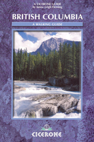
British Columbia - A Walking Guide

British Columbia is Janna Leigh Fleming’s Cicerone guide to the best walking opportunities in one of the world’s most remote wildernesses and outdoor destinations. The guide covers walks through a territory that includes 637 provincial parks, six national parks, wide regions of protected land and age-old forests, wild mountain rivers, grizzly bears and sockeye salmon. The guide is structured in 7 main sections - Vancouver Island, Haidi Gwaii (The Queen Charlotte Islands), Whistler and Squamish, Manning Provincial Park, Mount Revelstoke and Glacier National Parks, The Kootenays and British Columbia Rockies - totalling 50 trails though the Canadian wilderness. Each trail description opens with information on distance, time, difficulty rating, elevation change, the relevant
maps and the best time of year to complete the route. A detailed introduction gives practical advice on Accommodation in wilderness areas, driving on logging roads, tide-tables, national parks and surviving in the wild, including a comprehensive section on bears in the wild. Detailed trail descriptions are accompanied by sketch diagrams mapping the route in addition to colour and black and white photographs illustrating some of the highlights of the region.
RIP - This product is no longer available on our network. It was last seen on 25.09.2019

This page now acts as a permanent archive for this product. Add more information using the comments box below to ensure it can still be found by future generations.

Use our search facility to see if it is available from an alternative contributor.
  • External links may include paid for promotion
  • Availability: Out Of Stock
  • Supplier: Stanfords
  • SKU: 9781852843403
Availability: In Stock
£12.00

Product Description

British Columbia is Janna Leigh Fleming’s Cicerone guide to the best walking opportunities in one of the world’s most remote wildernesses & outdoor destinations. The guide covers walks through a territory that

Includes::
637 provincial parks, six national parks, wide regions of protected land & age-old forests, wild mountain rivers, grizzly bears & sockeye salmon. The guide is structured in 7 main sections
- Vancouver Isl&, Haidi Gwaii (The Queen Charlotte Islands), Whistler & Squamish, Manning Provincial Park, Mount Revelstoke & Glacier National Parks, The Kootenays & British Columbia Rockies
- totalling 50 trails though the Canadian wilderness. Each trail description opens with information on distance, time, difficulty rating, elevation change, the relevant maps & the best time of year to complete the route. A detailed introduction gives practical advice on Accommodation in wilderness areas, driving on logging roads, tide-tables, national parks & surviving in the wild, including a comprehensive section on bears in the wild. Detailed trail descriptions are accompanied by sketch diagrams mapping the route in addition to colour & black & white photographs illustrating some of the highlights of the region.

Reviews/Comments

Add New

Intelligent Comparison

Oooops!
We couldn't find anything!
Perhaps this product's unique.... Or perhaps we are still looking for comparisons!
Click to bump this page and we'll hurry up.

Price History

Vouchers

No voucher codes found.
Do you know a voucher code for this product or supplier? Add it to Insights for others to use.

Facebook

Jargon Buster

Black - A colour which does not emit any colour of the spectrum. Black absorbs all frequencies of the spectrum.
White - A colour combining all colours
World - A physical grouping, commonly used to describe earth and everything associated with ti
Colour - The categorised spectrum of light visable to humans
Year - The time it takes the planet earth to orbit the sun. This takes around 365.25 days.
Wide - Something with a large width.
Accommodation - A room in which someone can live in, for example in a hotel
Practical - Weather a task is easy to carry out and realistically succeed.
Year - 365 days (366 days in a leap year), the time taken for planet earth to make one full revolution around the sun.

Supplier Information

Stanfords
Stanfords was established in 1853 and opened their iconic Covent Garden flagship store in 1901. They have become the top retailer of maps, travel books and accessories in the UK and arguably offer the largest selection of maps and travel books worldwide. Famous names such as Captain Robert Falcon Scott, Ranulph Fiennes and Michael Palin have purchased from Stanfords. They now have a shop in Bristol and both stores together with other venues operate a calendar of events including talks, book signings and exhibitions. As a specialist map retailer, the map selection is comprehensive and includes road maps, street maps and walking maps from worldwide destinations, as well as a selection of world atlases and wall maps. Books include travel guides and travel literature. Stanfords also stock globes, from miniatures made of blue marble to magnificent floor-standing globes. The website features a selection of interesting articles on travel topics.
Page Updated: 2023-11-12 20:15:36

Community Generated Product Tags

Oh No! The productWIKI community hasn't generated any tags for this product yet!
Menu