More From Contributor

£12.00
British Columbia is Janna Leigh Fleming’s Cicerone guide to the best walking opportunities in one of the world’s most remote wildernesses & outdoor destinations. The guide covers walks through a territory that

Includes::
637 provincial parks, six national parks, wide regions of protected land & age-old forests, wild mountain rivers, grizzly bears & sockeye salmon. The guide is structured in 7 main sections
- Vancouver Isl&, Haidi Gwaii (The Queen Charlotte Islands), Whistler & Squamish, Manning Provincial Park, Mount Revelstoke & Glacier National Parks, The Kootenays & British Columbia Rockies
- totalling 50 trails though the Canadian wilderness. Each trail description opens with information on distance, time, difficulty rating, elevation change, the relevant maps & the best time of year to complete the route. A detailed introduction gives practical advice on Accommodation in wilderness areas, driving on logging roads, tide-tables, national parks & surviving in the wild, including a comprehensive section on bears in the wild. Detailed trail descriptions are accompanied by sketch diagrams mapping the route in addition to colour & black & white photographs illustrating some of the highlights of the region.


...
Archived Product
£10.99
British Columbia & Alberta, including the Banff & Jasper National Parks, on an indexed, double-sided road map presenting both provinces together at 1:2, 000, 000, plus more detailed mapping of the region’s main urban areas including Vancouver, Victoria, Calgary, etc. On one side both provinces are shown together at 1:2m with their road network presented on a base prominently highlighting their numerous national & provincial parks. Topography is shown by names of mountain ranges, plateaux, etc, with spot heights; numerous rivers & lakes are also named. Road classification indicates paved, loose surface, unimproved & seasonal routes. Driving distances are marked on main & selected secondary connections. The map also shows which locations are assessable by air services. Symbols mark campgrounds, tourist information offices, etc. The map has latitude & longitude grid at 1º intervals & a separate index for each province. On the reverse are enlargements & street maps: Vancouver at 1:100, 000 with the whole Fraser Valley shown at 1:250, 000; on the Vancouver Island – Victoria & Nanaimo at 60K plus the Saanich Peninsula at 175K; in the rest of BC – Whistler, Kamloops & Kelowna all at 60K; plus in Alberta – Calgary (110K), Edmonton (125K), & Banff, Lethbridge & Red Deer at 60K. Also included is a distance table plus an overview map of Yukon with the Northwest Territories & Nunavut. To see the list of currently available Canadian province & regional maps form the Map Art / Canadian Cartographics Corporation / JDM Géo publishing group, including waterproof & tear-resistant Fast Track titles, please click on the series link. ...
Archived Product
£8.99
British Columbia & Alberta, including the Banff & Jasper National Parks, on an indexed, double-sided road map presenting both provinces together at 1:2, 000, 000, plus more detailed mapping of the region’s main urban areas including Vancouver, Victoria, Calgary, etc. On one side both provinces are shown together at 1:2m with their road network presented on a base prominently highlighting their numerous national & provincial parks. Topography is shown by names of mountain ranges, plateaux, etc, with spot heights; numerous rivers & lakes are also named. Road classification indicates paved, loose surface, unimproved & seasonal routes. Driving distances are marked on main & selected secondary connections. The map also shows which locations are assessable by air services. Symbols mark campgrounds, tourist information offices, etc. The map has latitude & longitude grid at 1º intervals & a separate index for each province. On the reverse are enlargements & street maps: Vancouver at 1:100, 000 with the whole Fraser Valley shown at 1:250, 000; on the Vancouver Island – Victoria & Nanaimo at 60K plus the Saanich Peninsula at 175K; in the rest of BC – Whistler, Kamloops & Kelowna all at 60K; plus in Alberta – Calgary (110K), Edmonton (125K), & Banff, Lethbridge & Red Deer at 60K. Also included is a distance table plus an overview map of Yukon with the Northwest Territories & Nunavut. To see the list of currently available Canadian province & regional maps form the Map Art / Canadian Cartographics Corporation / JDM Géo publishing group, including waterproof & tear-resistant Fast Track titles, please click on the series link. ...
Archived Product
£12.79
British Columbia & the Canadian Rockies in the Countries & Regions series from Lonely Planet, market-leading comprehensive guides aimed at independent travellers & serving a large range of international destinations. Frank & informal in style, the guides explore an extensive range of sights, activities, accommodation, restaurants & nightlife & are designed for practical use while travelling on the road. Written & researched by a team of experts, each book is independent in its recommendations & suggestions, often offering individual takes on individual destinations. Widely recognised for their reliability, each Lonely Planet country & region guide has the same layout. Introductory sections profile the destination with individual chapters on particular highlights, getting started, (including when to go) itineraries, history, culture, arts, food & drink & the environment. Each guide is organised geographically by region, with individual sections detailing an extensive range of sights, places of interest, attractions, restaurants, nightlife, accommodation & any local activities. The guides have detailed explanations of historical context where relevant. There is also practical guidance on ...
Archived Product
£27.95
British Columbia in an A4-size, spiral-bound road atlas from Map Art, covering the southern part of the province at 1:500, 000 & the north at 1:1, 000, 000, plus enlargements, street plans, lists of forest recreational sites, wineries, etc. The main section covers the southern half of the province at 1:500, 000, with the northern part at 1:1, 000, 000. Road network distinguishes gravel highways & shows names of many regional & local roads. Intermediate driving distances are shown on main roads & border crossing to USA are marked. Local airports, railways with train stations, & ferries are marked, with national parks, provincial parks & reserves, & selected hiking trails highlighted. Symbols denote such features as campgrounds, major ski areas, & various facilities & places of interest. In addition to the main index of locations, there are also lists of Forest Recreational Sites, parks, wineries, museums & places of special interest. The more densely populated parts of the province: the environs of Vancouver, Lower Fraser Valley, Okanagan Valley, Nanaimo/ Qualicum Beach area, & the environs of Victoria are shown at a more detailed scale of 1:250, 000. Street plans at 1:25, 000 cover: Vancouver & Victoria with enlargements for the downtown areas, Nanaimo, Whistler, Kamloops, Kelowna, Penticton, & Prince George. All the plans are indexed &, where appropriate, show one way streets. Please note: following a number of changes among Canadian cartographic publishers titles previously published by Map Art Publishing may now be available under one of the following imprints: Map Art, Canadian Cartographics Corporation or JDM G ...
Archived Product
£22.50
A celebration of British Columbia through a cook s palate & a photographer s lens, this cookbook highlights the province s diverse edible landscape, from the Pacific Ocean s seafood to Okanagan fruit. The seasonal layout pairs an eclectic collection of made-from-scratch recipes with evocative images, paying tribute to wholesome unprocessed foods & the skilled farmers who grow them. Seafood lovers will find plenty of ideas for enjoying the Pacific s bounty with recipes for halibut, salmon, oysters, mussels, clams & spot prawns. B.C. s prized fruits are featured in summer pies, tarts, meringues & ice cream while fall & winter recipes showcase local pears, apples & cranberries. The Fraser Valley s meats appear throughout the book, as do the region s vegetables that make up vegetarian dishes like the award-winning Ratatouille Pie. There s even a section for getting back to basics with everything from stocks, to pasta, to honest-to-goodness real mayonnaise. British Columbia from Scratch features the province s most commonplace market ingredients, making this book as practical as it is beautiful.” ...
Archived Product
£9.99
British Columbia at 1:1, 250, 000 on an indexed double-sided map from ITMB, with street plans of central Vancouver & Victoria, plus very detailed plan of the Whistler Village. Coverage extends across to Calgary to include the Rocky Mountains with Banff & Jasper National Parks. The province is divided north/south with a good overlap between the sides. Topography is presented by altitude colouring, with elevation & spot heights given in feet. National & provincial parks & forests are highlighted. The map shows the road network indicating gravel roads & tracks, with driving distances given on main routes & locations of petrol stations marked in more remote areas, particularly in the northern part of the province. Railway lines & ferry routes are included & local airports are indicated. A range of symbols highlight tourist information offices, camping & RV sites, recreational areas, & other places of tourist interest. The map has a latitude & longitude grid at intervals of 1º & an index of localities. Also included are street plans of central Vancouver (1:12, 500) & Victoria (1:20, 000), plus a very detailed plan of the Whistler Village with names of hotels, locations of car parks, gondola & chairlift stations, etc. The map is part of the publisher’s series covering Canadian provinces. ...
Archived Product
£9.99
75-page, A5 paperback atlas of British Columbia from the Vancouver based ITMB, with street plans of central Vancouver, Victoria & Whistler Village, plus enlargements for the southern tip of the Vancouver Isl&, the environs of Vancouver & the recreational area around Whistler. The southern half of the province, including most of the Queen Charlotte Islands is shown at 1:925, 000, with the remainder of the province at 1:1, 250, 000. Altitude colouring provides very generalized indication of the topography, with peak names & heights given in some areas. National & provincial parks & protected areas are prominently marked. Numerous camping & RV sites are highlighted, including some in more remote areas for which a more detailed map would be necessary. Symbols indicate recreational areas for hiking, skiing, rafting, etc. as well as various places of interest. The atlas shows the province’s road & rail networks, indicating roads passable only in dry weather or in 4WD vehicle. In remote areas locations petrol stations are marked. Enlargements are provided for the environs of Vancouver (1:185, 000) & the southern tip of Vancouver Island (1:250, 000). The recreational area around Whistler 1:50, 000) shows gondola lines & chair lifts. Also included are plans of Vancouver (the inner districts, plus enlargements for downtown), central Victoria, plus Whistler Village.*PLEASE NOTE: The grid showing how British Columbia is divided between the individual pages of the atlas has no place names, greatly reducing its suitability for visitors unfamiliar with the geography of the province.* ...
Archived Product
£8.99
British Columbia, with coverage extending to Calgary to include the Banff & Jasper National Parks, on an indexed, double-sided road map presenting the whole province at 1:1, 500, 000, plus numerous enlargement & street plans providing more detailed mapping of the Vancouver
- Fraser Valley area & several towns. The map divides the province north/south with a generous overlap between the sides. Along the coast coverage extends south to include Seattle & the Olympic NP in USA (main roads only). Enlargement at 1:375, 000 show in greater detail the Fraser Valley area & Greater Victoria. Street plans at scales from 50K to 75K cover Nanaimo, Port Alberni, Whistler, Campbell River, Vernon, Williams, Lake, Cranbrook, Kamloops, Penticton, Kelowna & Powell River, Prince George, Prince Rupert, Smithers, Terrace, Dawson Creek, Fort St. John & Kitimat. Also provided is an overview map of Yukon with most of Northwest Territories & Nunavut. On the mapping at 1:1, 500, 000 road & rail networks are presented on a base with colouring highlighting national/provincial parks, plus plenty of names of mountain ranges, plateaux, peaks, smaller rivers & lakes, etc. Road network indicates paved, loose surface & unimproved roads plus seasonal routes, & shows driving distances on main & secondary roads. Symbols indicate campsites, ski areas & various places of interest. The map has no geographical coordinates. Also provided is a list of ferry operators. To see the list of currently available Canadian province & regional maps form the Map Art / Canadian Cartographics Corporation / JDM Géo publishing group, including waterproof & tear-resistant Fast Track titles, please click on the series link.
...
Archived Product

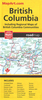
British Columbia FastTrack

British Columbia, with coverage extending to Calgary to include the Banff and Jasper National Parks, on an indexed, waterproof and tear-resistant, handy size FastTrack map, presenting the whole province on two overlapping panels at 1:2, 000, 000, with more detailed enlargements and street plans covering the Vancouver at 1:1, 275, 000, the Victoria and Nanaimo areas of Vancouver Island at 1:250, 000, plus on street maps at 1:50, 000 of Kelowna, Kamloops, Prince George, Summerland, Penticton and Vernon. Road network is presented on a base with colouring highlighting national/provincial parks and indicates paved, loose surface, unimproved and seasonal routes, and shows driving distances on main roads. Symbols indicate campsites, ski areas, tourist information offices, etc.
The map has no geographical coordinates.To see the list of currently available Canadian province and regional maps form the MapArt / Canadian Cartographics Corporation / JDM Géo publishing group, including waterproof and tear-resistant FastTrack titles, please click on the series link.
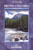
RIP - This product is no longer available on our network. It was last seen on 25.09.2019

This page now acts as a permanent archive for this product. Add more information using the comments box below to ensure it can still be found by future generations.

Use our search facility to see if it is available from an alternative contributor.
  • External links may include paid for promotion
  • Availability: Out Of Stock
  • Supplier: Stanfords
  • SKU: 9780886404710
Availability: In Stock
£10.99

Product Description

British Columbia, with coverage extending to Calgary to include the Banff & Jasper National Parks, on an indexed, waterproof & tear-resistant, handy size Fast Track map, presenting the whole province on two overlapping panels at 1:2, 000, 000, with more detailed enlargements & street plans covering the Vancouver at 1:1, 275, 000, the Victoria & Nanaimo areas of Vancouver Island at 1:250, 000, plus on street maps at 1:50, 000 of Kelowna, Kamloops, Prince George, Summerl&, Penticton & Vernon. Road network is presented on a base with colouring highlighting national/provincial parks & indicates paved, loose surface, unimproved & seasonal routes, & shows driving distances on main roads. Symbols indicate campsites, ski areas, tourist information offices, etc. The map has no geographical coordinates. To see the list of currently available Canadian province & regional maps form the Map Art / Canadian Cartographics Corporation / JDM Géo publishing group, including waterproof & tear-resistant Fast Track titles, please click on the series link.

Reviews/Comments

Add New

Intelligent Comparison

Oooops!
We couldn't find anything!
Perhaps this product's unique.... Or perhaps we are still looking for comparisons!
Click to bump this page and we'll hurry up.

Price History

Vouchers

No voucher codes found.
Do you know a voucher code for this product or supplier? Add it to Insights for others to use.

Facebook

Jargon Buster

Waterproof - Resistant to water, usualy specified by depth in metres
Size - is the measurement of how big an object is in space.
Network - A link and communication between things. Often computers or people.
Loose - The opposite to tight
Road - a manmade lane or a path that is used to speed up travel.
Resistant - Something that can repel against something.
Regional - An adjective to describe a set geographic area.

Supplier Information

Stanfords
Stanfords was established in 1853 and opened their iconic Covent Garden flagship store in 1901. They have become the top retailer of maps, travel books and accessories in the UK and arguably offer the largest selection of maps and travel books worldwide. Famous names such as Captain Robert Falcon Scott, Ranulph Fiennes and Michael Palin have purchased from Stanfords. They now have a shop in Bristol and both stores together with other venues operate a calendar of events including talks, book signings and exhibitions. As a specialist map retailer, the map selection is comprehensive and includes road maps, street maps and walking maps from worldwide destinations, as well as a selection of world atlases and wall maps. Books include travel guides and travel literature. Stanfords also stock globes, from miniatures made of blue marble to magnificent floor-standing globes. The website features a selection of interesting articles on travel topics.
Page Updated: 2023-11-12 20:15:36

Community Generated Product Tags

Oh No! The productWIKI community hasn't generated any tags for this product yet!
Menu