
 United Kingdom
 France
 Germany
 Netherlands
 Sweden
 USA
USA
 Italy
Italy
 Spain
Spain
More From Contributor

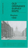

Royston 1904
Royston in 1904 in a fascinating series of reproductions of old Ordnance Survey plans in the Alan Godfrey Editions, ideal for anyone interested in the history of their neighbourhood or family. The map covers the village of Royston, about three miles north of Barnsley. Coverage extends from the Railway Hotel eastward to Whincover and Royston Bridge, and from the GCR station southward to the Old Ring of Bells pub. Features include St John`s church, Chantry House, old Grammar School, stretches of the Barnsley Canal, Ship Inn (original site at Whincover), short stretch of Midland Railway and Monckton Main Colliery Railway, GCR `Barnsley Coal Railway Extension` with Notton for Royston station, Manor House, Applehaigh, Wellfield House, etc. On the reverse are directories of Royston
for both 1889 and 1936.About the Alan Godfrey Editions of the 25” OS Series:Selected towns in Great Britain and Ireland are covered by maps showing the extent of urban development in the last decades of the 19th and early 20th century. The plans have been taken from the Ordnance Survey mapping and reprinted at about 15 inches to one mile (1:4, 340). On the reverse most maps have historical notes and many also include extracts from contemporary directories. Most maps cover about one mile (1.6kms) north/south, one and a half miles (2.4kms) across; adjoining sheets can be combined to provide wider coverage.FOR MORE INFORMATION AND A COMPLETE LIST OF ALL AVAILABLE TITLES PLEASE CLICK ON THE SERIES LINK.
for both 1889 and 1936.About the Alan Godfrey Editions of the 25” OS Series:Selected towns in Great Britain and Ireland are covered by maps showing the extent of urban development in the last decades of the 19th and early 20th century. The plans have been taken from the Ordnance Survey mapping and reprinted at about 15 inches to one mile (1:4, 340). On the reverse most maps have historical notes and many also include extracts from contemporary directories. Most maps cover about one mile (1.6kms) north/south, one and a half miles (2.4kms) across; adjoining sheets can be combined to provide wider coverage.FOR MORE INFORMATION AND A COMPLETE LIST OF ALL AVAILABLE TITLES PLEASE CLICK ON THE SERIES LINK.

Product Description
Reviews/Comments
Add New
Intelligent Comparison
Archived Product

Boston 1904 Stanfords
£3.50
Archived Product

Royton 1932 Stanfords
£3.50
Archived Product
Syston 1902 Stanfords
£2.95
Archived Product

Syston 1902 Stanfords
£3.50
Archived Product
Gorleston 1904 Stanfords
£2.95
Archived Product

Gorleston 1904 Stanfords
£3.50
Archived Product
Woolton 1904 Stanfords
£2.95
Archived Product

Woolton 1904 Stanfords
£3.50
Vouchers
No voucher codes found.
Do you know a voucher code for this product or supplier? Add it to Insights for others to use.
Do you know a voucher code for this product or supplier? Add it to Insights for others to use.
 Denmark