
 United Kingdom
 France
 Germany
 Netherlands
 Sweden
 USA
USA
 Italy
Italy
 Spain
Spain
More From Contributor


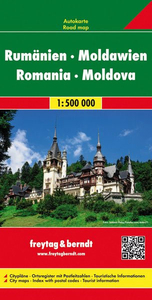
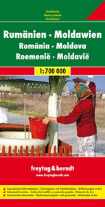
Romania And Moldova
Romania and Moldova at 1:800, 000 from MairDumont with special features to aid route planning and navigating: a set of peel-on/peel-off stickers, removable without damaging the surface, for marking chosen locations, plus a fold-out flap in the jacket which provides an overview of the whole area covered by the map with the adjoining regions and highlights popular locations; its grid reference system in the margins makes it easier to find places on the main map. Subtle relief shading, spot heights and names of mountain ranges indicate the topography. Road network, although in some places less detailed than on other maps and with fewer small villages, provides clearer distinction between local roads and tracks. Toll roads, restricted roads, and scenic routes are marked, plus
gradients and opening months of mountain passes. Intermediate driving distances are shown on main and secondary roads. Rail network indicates terminals with car transport facilities. Mountain rack-railways, cable car lines, ferry routes, and local airports are marked. The map clearly highlights particularly interesting towns and villages, as well as national parks and other sites worth visiting, campsites, beaches, etc. Main towns within Transylvania are shown with their historical German names. Latitude and longitude grid is drawn at intervals of 1
gradients and opening months of mountain passes. Intermediate driving distances are shown on main and secondary roads. Rail network indicates terminals with car transport facilities. Mountain rack-railways, cable car lines, ferry routes, and local airports are marked. The map clearly highlights particularly interesting towns and villages, as well as national parks and other sites worth visiting, campsites, beaches, etc. Main towns within Transylvania are shown with their historical German names. Latitude and longitude grid is drawn at intervals of 1
Product Description
Reviews/Comments
Add New
Intelligent Comparison
Archived Product
Romania And Moldova Stanfords
£4.99
Archived Product
Romania - Moldova Stanfords
£9.50
Archived Product
Romania - Moldova F&B Stanfords
£10.99
Archived Product
Romania - Moldova F&B Stanfords
£10.99
Archived Product

Romania & Moldova ITMB Stanfords
£9.99
Archived Product
Romania And Moldova SUPERCEDED Stanfords
£12.99
Archived Product
Romania Road Atlas Stanfords
£17.95
Archived Product

Romania Road Atlas Stanfords
£13.50
Vouchers
No voucher codes found.
Do you know a voucher code for this product or supplier? Add it to Insights for others to use.
Do you know a voucher code for this product or supplier? Add it to Insights for others to use.
 Denmark