
 United Kingdom
 France
 Germany
 Netherlands
 Sweden
 USA
USA
 Italy
Italy
 Spain
Spain
More From Contributor

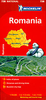


Romania Road Atlas
Romania on a compact spiral-bound road atlas from the Budapest based Cartographia, clearly showing the country’s road network and indicating roads closed to general traffic, scenic routes, border crossings, and intermediate driving distances. Railways, administrative boundaries, and national parks are marked, and symbols highlight various places of interest, including campsites, spas and beaches, World Heritage sites, folk museums, wooden churches, etc. Hill-shading represents the relief and some spot heights are included for significant peaks. Latitude and longitude grid is drawn at 10’ intervals.

Product Description
Reviews/Comments
Add New
Vouchers
No voucher codes found.
Do you know a voucher code for this product or supplier? Add it to Insights for others to use.
Do you know a voucher code for this product or supplier? Add it to Insights for others to use.
 Denmark