
 United Kingdom
 France
 Germany
 Netherlands
 Sweden
 USA
USA
 Italy
Italy
 Spain
Spain
More From Contributor


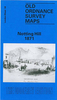


Notting Hill 1893
Notting Hill in 1893 in a fascinating series of reproductions of old Ordnance Survey plans in the Alan Godfrey Editions, ideal for anyone interested in the history of their neighbourhood or family. Three versions cover the area from White City eastward to Pembridge Square and St Stephen`s Square, and capture the part of Kensington known as Notting Hill. In the north-east is a portion of Paddington parish, including Westbourne Park station; to the west is a part of Hammersmith parish, rural in the early map but later developed to include White City.The 1893 map shows Notting Hill entirely built up, with streets and houses as far as Latimer Road, which now has a station. Features include Mary Place Workhouse, Phoenix Brewery, Avondale Park, Kensington Public Baths, St Charles RC
College, Franciscan Convent, Carmelite Convent, St Quintin Park, St Quintin & Wormwood Scrubbs station. Beyond the West London Railway is an area of brickfields and (apparently) piggeries. On the reverse are street directories for Ladbroke Grove, Ladbroke Square and Lancaster Road. About the Alan Godfrey Editions of the 25” OS Series:Selected towns in Great Britain and Ireland are covered by maps showing the extent of urban development in the last decades of the 19th and early 20th century. The plans have been taken from the Ordnance Survey mapping and reprinted at about 15 inches to one mile (1:4, 340). On the reverse most maps have historical notes and many also include extracts from contemporary directories. Most maps cover about one mile (1.6kms) north/south, one and a half
miles (2.4kms) across; adjoining sheets can be combined to provide wider coverage.FOR MORE INFORMATION AND A COMPLETE LIST OF ALL AVAILABLE TITLES PLEASE CLICK ON THE SERIES LINK.

Product Description
Reviews/Comments
Add New
Intelligent Comparison
Archived Product
Notting Hill 1914 Stanfords
£2.95
Archived Product

Notting Hill 1871 Stanfords
£3.50
Archived Product

Notting Hill Stanfords
£14.99
Archived Product
Notting Hill Stanfords
£2.99
Vouchers
No voucher codes found.
Do you know a voucher code for this product or supplier? Add it to Insights for others to use.
Do you know a voucher code for this product or supplier? Add it to Insights for others to use.
 Denmark