More From Contributor

£4.99
Madeira in the Pocket Guide series from Berlitz; a collection of handy, pocket-sized guides dedicated to an extensive range of cities, regions & countries worldwide. Written in narrative form, individual guides explore the history, main sights & attractions, food & drink, accommodation & local culture of the destination in detail. Each Berlitz pocket guide has a similar format, with colour-coded sections helping readers locate information quickly in addition to distinctive chapters exploring the city or region. An introduction outlines the destination for visitors & a section dedicated to 'A Brief History' actually explores the area in relative depth. A where to go chapter is organized by region & city & is written in prose form with references to individual sites highlighted in bold for clarity. There are also further suggestions on where & when to eat. Recommendations for leisure activities in the region, including sport, nightlife & shopping, are also provided & tailored accordingly for each destination. Handy travel tips are listed alphabetically in a dedicated section, providing practical guidance & helping visitors make the most of their stay. The main hotels, particularly for cities, are also listed in an accommodation section, offering a brief overview with approximate price bandings & relevant contact details. ...
Archived Product
£5.99
Madeira in the Pocket Guide series from Berlitz; a collection of handy, pocket-sized guides dedicated to an extensive range of cities, regions & countries worldwide. Written in narrative form, individual guides explore the history, main sights & attractions, food & drink, accommodation & local culture of the destination in detail. Each Berlitz pocket guide has a similar format, with colour-coded sections helping readers locate information quickly in addition to distinctive chapters exploring the city or region. An introduction outlines the destination for visitors & a section dedicated to `A Brief History` actually explores the area in relative depth. A where to go chapter is organized by region & city & is written in prose form with references to individual sites highlighted in bold for clarity. There are also further suggestions on where & when to eat. Recommendations for leisure activities in the region, including sport, nightlife & shopping, are also provided & tailored accordingly for each destination. Handy travel tips are listed alphabetically in a dedicated section, providing practical guidance & helping visitors make the most of their stay. The main hotels, particularly for cities, are also listed in an accommodation section, offering a brief overview with approximate price bandings & relevant contact details. ...
Archived Product
£5.99
From the gorgeous capital of Funchal, to the wealth of hidden coves & beaches on the isl&, to the hiking trails of Pico do Arieiro, Madeira has much to tempt the visitor. Berlitz Pocket Guide Madeira is a concise, full-colour travel guide that combines lively text with vivid photography to highlight the best that this island has to offer. Inside Madeira Pocket Guide:· Where To Go details all the key sights on the isl&, while handy maps on the cover flaps help you find your way around, & are cross-referenced to the text.· Top 10 Attractions gives a run-down of the best sights to take in on your trip.· Perfect Tour provides an itinerary of the isl&.· What To Do is a snapshot of ways to spend your spare time on the isl&, from chartering a boat & exploring the island`s many beaches, to hiking up Pico das Torres, to exploring the cultural capital of Funchal.· Essential information on Madeira`s culture, including a brief history of the isl&.· Eating Out covers the island`s best cuisine.· Curated listings of the best hotels & restaurants.· A-Z of all the practical information you`ll need. ...
Archived Product
£5.99
Madeira`s favourite map just got a whole lot better. Madeira Tour & Trail Map is now on a larger 960mm by 700mm double sided map sheet; a full 33% larger than the 8th edition it replaces. Super-Durable edition comes with a 2 year adventurous use wear & tear guarantee, see Discovery Walking Guides website for details. Specialist concertina map folding means the 960 by 700 double sided map folds quickly to its 235mm by 120mm pocket size. This most detailed map of Madeira

Includes::
our ` Tour & Trail` level of detail ranging from major roads to secondary roads to minor roads to streets & camino rural narrow country roads, plus dirt roads & walking trails. Altitude background colouring is designed to clearly show the altitude range when travelling across the island by car or on foot. 100 metre & 50 metre contours are clearly shown on the map along with a large number of individual height points & all of the official ` Trig` points. Tour & Trail attention to detail is legendary as is our useful symbol range including miradors, picnic areas, petrol stations, bar/restaurants & parking areas where you can pull off the road safely. You will easily identify springs, caves, sports grounds, cemetries, churchs, chapels, lighthouses, towers & forts, camping areas, wind turbines, hotels etc. For adventurers on foot Tour & Trail Maps are researched & designed by hikers for use by hikers. Our comprehensive gps ground surveys produce the best mapping available but the value of this on the ground research becomes even more important when you leave the tarmac. All of our DWG walking routes are accurately gps surveyed giving you confidence in the accuracy of our Tour & Trail Maps. Madeira Tour & Trail Map 9th edition

Includes::
all the walking routes from ` Madeira Walks` volumes 1 & 2 by Shirley Whitehead highlighted in Red while other published walking routes (Rother & Landscapes) are highlighted in Green. It all adds up to the most useful map of Madeira that you can buy anywhere. In use maps have a very tough life so you will appreciate our specialist concertina map fold that means that you can quickly open the map, & more importantly fold it back up to its pocket size after use. Paper maps will always suffer from the repeated unfolding, folding to the section you want to use, & then refolding. We recommend everybody to obtain our Super-Durable editions printed with 100% oxygenation inks on Polyart by the UK`s leading map printer, which produces a map that feels like silk but will stand up to the roughest treatment of outdoor adventuring & yet fold up like new at the end of your adventure. Tour & Trail Super-Durable Maps are more expensive than paper maps, but represent better value as they produce a lightweight map that feels like silk while being both water-proof & incredibly tough so that after even the toughest of adventures your Tour & Trail Super-Durable Map will fold up like new. Polyart is made from high-density polyethylene (HDPE) & is therefore 100% recyclable in category 2 HDPE. For more information see the Polyart website.


...
Archived Product
£8.99
Madeira Tour & Trail Map from Discovery Walking Guides, Super-Durable version, covering the island at 1:40, 000 on a double-sided GPS compatible map with hiking trails as well as information for exploring Madeira by car. Madeira is divided east/west, with a generous overlap between the sides. The map has contours at 50m intervals with additional altitude colouring & plenty of spot heights to provide a vivid picture of the island ...
Archived Product
£5.99
Madeira Tour & Trail is an updated, double sided, indexed, map at a scale of 1:40, 000 designed primarily for walkers but will be of use to motorists on the island as well. A large number of walking routes are marked on the map. Main & minor roads, dirt tracks, footpaths, trails are all very clearly marked, as are regional boundaries. Vertiginous sections on are especially marked, as are tunnels & cable cars. Additional information concerning routes currently in construction is also provided. Petrol stations & dedicated parking facilities are shown, as are rest stops & picnic areas. Camp sites & hotels are indicated, as well as the island's famous gardens & historical sites. Longitude & latitude co-ordinates are given at one minute intervals, detailed relief shading & contours are shown, as are spot heights. An indexed street plan of central Funchal is provided as an inset on the larger map. Current edition of this map was published in 2009. ...
Archived Product
£8.99
Madeira Tour & Trail is a double sided, indexed, waterproof map at a scale of 1:40, 000. This updated, super durable map is designed primarily for walkers but will be of use to motorists on the island as well. A large number of walking routes are marked on the map. Main & minor roads, dirt tracks, footpaths, trails are all very clearly marked, as are regional boundaries. Vertiginous sections on are especially marked, as are tunnels & cable cars. Additional information concerning routes currently in construction is also provided. Petrol stations & dedicated parking facilities are shown, as are rest stops & picnic areas. Camp sites & hotels are indicated, as well as the island's famous gardens & historical sites. Longitude & latitude co-ordinates are given at one minute intervals, detailed relief shading & contours are shown, as are spot heights. An indexed street plan of central Funchal is provided as an inset on the larger map. Current edition of this map was published in 2009. ...
Archived Product
£9.95
Madeira at 1:35, 000 on a brightly coloured, double-sided road map from the Portuguese publishers Turinta emphasising the island’s main roads & places of interest, plus a large street plan of central Funchal & a map of the nearby Porto Santo at 1:90, 000. The map divides Madeira east/west, with a good overlap between the sides. Place names are in large, easy-to-read print. Bright altitude colouring with contours at 50m intervals shows the island’s topography, with build-up areas also prominently coloured. Road network emphasises principal & regional routes. Driving distances are shown on principal routes only & locations of petrol stations are marked. The map also indicates locations & roads with bus connections. Icons show places of interest, including campsites, viewpoints, beaches, etc. The map has latitude & longitude lines at 3’ intervals. A street plan of Funchal highlights main traffic arteries, names selected streets & indicates various facilities including car parks, petrol stations, etc. ...
Archived Product
£14.95
Walking in Madeira is accomplished walker Paddy Dillon’s Cicerone guide to walking on the volcanic islands of Madeira & Porto Santo in the Atlantic Ocean. The walks covered stretch from sea level to the highest peaks on the islands & explore the cliff coastline, wander from village to village along level levada paths, penetrating dense laurisilva forests & traversing stone-paved paths from peak to peak in the high mountains. This new edition takes account of the sweeping change on Madeira in terms of its new network of underground road tunnels, bus routes & accommodation & food & drink options on & around the walks. The guide is structured in seven main sections
- Eastern Madeira, Funchal to Santana, The High Mountains, Jardim da Serra, Paul de Serra, Western Madeira & Porto Santo
- detailing a total of 60 walks on the islands. Each walk has an Information Box with details of starting & finishing points, distance, total ascent & descent, time, the relevant maps, terrain, refreshments & local transport options. A detailed introduction gives practical guidance on getting to & around Madeira, accommodation, food & drink, weather, health issues & emergencies. There is also an overview of the island’s location, geology, history & landscape & details about native trees, flowers, birds & animals. Detailed walk descriptions are accompanied by sketch diagrams mapping the route in addition to colour photographs illustrating some of the highlights of the islands.

...
Archived Product

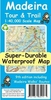
Madeira Tour And Trail Map PAPER

Madeira Tour and Trail Map from Discovery Walking Guides, paper version, covering the island at 1:40, 000 on a double-sided GPS compatible map with hiking trails as well as information for exploring Madeira by car.Madeira is divided east/west, with a generous overlap between the sides. The map has contours at 50m intervals with additional altitude colouring and plenty of spot heights to provide a vivid picture of the island
RIP - This product is no longer available on our network. It was last seen on 25.09.2019

This page now acts as a permanent archive for this product. Add more information using the comments box below to ensure it can still be found by future generations.

Use our search facility to see if it is available from an alternative contributor.
  • Availability: Out Of Stock
  • Supplier: Stanfords
  • SKU: 9781904946779
Availability: In Stock
£5.99

Product Description

Madeira Tour & Trail Map from Discovery Walking Guides, paper version, covering the island at 1:40, 000 on a double-sided GPS compatible map with hiking trails as well as information for exploring Madeira by car. Madeira is divided east/west, with a generous overlap between the sides. The map has contours at 50m intervals with additional altitude colouring & plenty of spot heights to provide a vivid picture of the island

Reviews/Comments

Add New

Price History

Vouchers

No voucher codes found.
Do you know a voucher code for this product or supplier? Add it to Insights for others to use.

Facebook

Jargon Buster

GPS - Global Positioning System - Global position using satellites
Paper - A thin sheet mainly used for writing. Available in a variety of colours. Made mainly from wood pulp.
Hiking - An outdoor activity envolving walking in nature
Car - A machine used for transport which runs on roads
Altitude - Something that can be quite high in relation to sea or ground level.

Supplier Information

Stanfords
Stanfords was established in 1853 and opened their iconic Covent Garden flagship store in 1901. They have become the top retailer of maps, travel books and accessories in the UK and arguably offer the largest selection of maps and travel books worldwide. Famous names such as Captain Robert Falcon Scott, Ranulph Fiennes and Michael Palin have purchased from Stanfords. They now have a shop in Bristol and both stores together with other venues operate a calendar of events including talks, book signings and exhibitions. As a specialist map retailer, the map selection is comprehensive and includes road maps, street maps and walking maps from worldwide destinations, as well as a selection of world atlases and wall maps. Books include travel guides and travel literature. Stanfords also stock globes, from miniatures made of blue marble to magnificent floor-standing globes. The website features a selection of interesting articles on travel topics.
Page Updated: 2023-11-12 20:15:36

Community Generated Product Tags

Oh No! The productWIKI community hasn't generated any tags for this product yet!
Menu