More From Contributor

£7.99
Helsinki is one title in the main travel guide series from Bradt publishers
- a company whose ethos focuses on responsible travel;
...
Archived Product
£8.50
Helsinki City Map at a scale of 1:15, 000, from Finnish survey publishers Karttakeskus, is an indexed, easy to read street plan of the capital, with an enlargement of the area surrounding the railway station & central Mannerheimintie given at a scale of 1:5000. The rail station, metro stations, tramway lines & stops, bus stations & bus terminals, official taxi ranks & car parks, as well as petrol stations are detailed & one way roads are indicated. Ferry ports with route destination are also marked. Main points of visitor interest, e.g. the botanical garden, the Finnish National Gallery, or the Mannerheim house museum, are illustrated by numbered pink circles (numbers relate to a list of place names on the legend) & named pink stars on both the map proper & the & enlargement. Other legend symbols detail the locations of tourist information points, hotels, youth hostels & camping sites, & where to go for medical treatment.A tram route plan & an overview road map of the main routes into Helsinki, at a scale of 1:100, 000, are included. English is one of seven languages on the map legend. ...
Archived Product
£6.99
Helsinki at 1:15, 000 on a pocket-size street plan from Mair Dumont printed on durable, waterproof & tear-resistant synthetic paper, with tram & bus routes shown with stops & line numbers, metro stations clearly marked & also shown on the separate diagram of the whole network, one way streets, lists of useful addresses, etc The plan covers the city with its outer districts & shows metro lines, tram & bus routes with stops & line numbers, as well as piers & ferry connections in the harbour. Also marked are one way streets, car parks & pedestrianized areas. Important buildings & places of interest are highlighted. Multilingual map legend

Includes::
English. The index is on the reverse side &

Includes::
lists of useful contact details for tourist information offices, hotel reservation, car hire, places of entertainment, emergency services, etc. The map also

Includes::
a diagram of the metro network & a small road map of the city’s environs.


...
Archived Product
£10.99
Helsinki on a laminated, waterproof & tear-resistant street plan from Karttakeskus combining a street plan of the city with a detailed enlargement of its town centre, plus a road map of the capital’s environs, a diagram of the tram network, & brief descriptions of 30 most interesting sights prominently highlighted on the plans. Helsinki’s central districts are shown on an indexed street plan at 1:15, 000, indicating tram lines with route numbers, metro stations, taxi ranks, one way streets, car parks & petrol stations, ferry terminals, selected hotels, etc. Streets are annotated with selected house numbers for easier identification of addresses. The city centre around the railway station is also shown in much greater detail at 1:5, 000. 30 of the city’s most interesting places are prominently marked & cross-referenced to brief descriptions accompanied by small colour photos. The plans are accompanied by a large, clear diagram of Helsinki’s tram network, plus a road map showing the capital’s environs at 1:100, 000. Map legend & all the text include English. The map can be customised with suitable marker pens, & is laminated in a way similar to the old cloth-dissected maps, so that sections of it can be easily viewed without damaging the whole sheet. ...
Archived Product
£9.99
Covers the whole city including the airport, & reaching southern Vantaa. One-way streets are indicated & pedestrian zones, car parks & public transport routes
- bus, tram, metro, rail & ferry
- are marked. Other details include: churches, police stations, hospitals, schools, post offices, campsites, tourist information offices, monuments, parks, forests, marshes. Legend

Includes::
English. There is a diagram of the commuter rail & metro system & a small road map of the Helsinki
- Turku region. Street & district index on reverse.


...
Archived Product
£7.99
Helsinki in the Pocket Guide series from Insight provides detailed commentary on a collection of itinerary based trips in a handy pocket format. Each guide has an historical & cultural introduction, profiling the growth of the region or city. There is also a large selection of localised & pedestrian friendly tour itineraries designed to take in the major sites, as well as a chapter on excursions to other destinations within easy reach. Further sections detail leisure activities including shopping, eating out, nightlife, festivals & local events with accompanying addresses & contact details where relevant. There is also practical guidance on transport, local services, language & accommodation. Each guide also has a large selection of colour photographs & a pull-out pocket map giving an overview of the region. ...
Archived Product
£23.99
Karttakeskus’ Water touring maps are a completely new type of map series. The pre-folded maps made from waterproof & rip-proof material can fit into a small space on the boat, but when opened, they cover a wide area. In this way, the water touring map is e.g. an excellent planning tool alongside electronic navigation solutions, offering a wide overview for e.g. route planning. On the other h&, the waterproof material makes the map easy to handle in e.g. an open boat or sailing boat. Water touring maps: In land areas, the maps have been supplemented with the National Land Survey of Finland’s Topographic Database material. New map sheet division. Size 70 × 100 cm, folded 23.3 × 11.3 cm. Additional themes incl. slipways & camp fire sites & landfalls. Scale in maritime areas 1:60 000, inland waterways 1:50 000 Base map source: Finnish Transport Agency. Not for navigation use. Does not meet the requirements of an official nautical chart. ...
Archived Product
£11.99
The excitement around Scandinavian crime fiction has focused largely on Sweden, but Finland
- as poignantly revealed here
-

...
Archived Product
£6.99
This vibrant series spans over 170 destinations worldwide. It contains the most comprehensive list of UK guides currently available. It offers practical listings to suit varied budgets & tastes. Compact format quickly locates the top must see & do attractions. Imaginative suggestions reveal each destination's hidden gems. This title is organised by recognisable areas, making orientation easy. ...
Archived Product

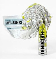
Helsinki Crumpled City Map

Helsinki Crumpled City Map from a collection of street plans of major cities printed on soft, very lightweight (approximately only 20g) and yet extremely tear-resistant and 100% waterproof material, specifically designed to be scrunched and crammed into pockets, handbags and backpacks, either on its own or in the pouch from the same material provided with each map. Creases are a fully intentional part of the quirkiness of the Crumpled City maps – the more battered they are they better they look.Parks and other green spaces are highlighted, as are metro stations, and important buildings are named. Each map also highlights 10 recommended “soulsights”, imaginatively chosen to present the essence of each city rather than the most obvious tourist destinations. The accompanying
index placed next to the map lists locations of tourist interest: selected streets and squares, monuments and historical places, museums and galleries, parks, etc. Whilst cartographically these Crumpled City maps provide perhaps not the most precise representation of the street network, they are handy for sightseeing, light and durable, can be used as a table cloth when picnicking in the Luxembourg Gardens, Hyde Park, the Retiro or the Central Park, or just as an unusual decoration… Selected cities are also presented on more colourful ‘junior’ maps, specially designed for children. Drawings highlight not only important buildings and famous locations but also places which will specifically appeal to children: toy shops, bookshops, best ice cream, etc. Each title has a
list of the recommended not-to-be missed locations with addresses and, where available, websites.To see the full list of cities covered by this unique series please click on the series link.
RIP - This product is no longer available on our network. It was last seen on 25.09.2019

This page now acts as a permanent archive for this product. Add more information using the comments box below to ensure it can still be found by future generations.

Use our search facility to see if it is available from an alternative contributor.
  • Availability: Out Of Stock
  • Supplier: Stanfords
  • SKU: 9788890573286
Availability: In Stock
£10.00

Product Description

Helsinki Crumpled City Map from a collection of street plans of major cities printed on soft, very lightweight (approximately only 20g) & yet extremely tear-resistant & 100% waterproof material, specifically designed to be scrunched & crammed into pockets, handbags & backpacks, either on its own or in the pouch from the same material provided with each map. Creases are a fully intentional part of the quirkiness of the Crumpled City maps – the more battered they are they better they look. Parks & other green spaces are highlighted, as are metro stations, & important buildings are named. Each map also highlights 10 recommended “soulsights”, imaginatively chosen to present the essence of each city rather than the most obvious tourist destinations. The accompanying index placed next to the map lists locations of tourist interest: selected streets & squares, monuments & historical places, museums & galleries, parks, etc. Whilst cartographically these Crumpled City maps provide perhaps not the most precise representation of the street network, they are handy for sightseeing, light & durable, can be used as a table cloth when picnicking in the Luxembourg Gardens, Hyde Park, the Retiro or the Central Park, or just as an unusual decoration… Selected cities are also presented on more colourful ‘junior’ maps, specially designed for children. Drawings highlight not only important buildings & famous locations but also places which will specifically appeal to children: toy shops, bookshops, best ice cream, etc. Each title has a list of the recommended not-to-be missed locations with addresses &, where available, websites. To see the full list of cities covered by this unique series please click on the series link.

Reviews/Comments

Add New

Intelligent Comparison

Oooops!
We couldn't find anything!
Perhaps this product's unique.... Or perhaps we are still looking for comparisons!
Click to bump this page and we'll hurry up.

Price History

Vouchers

No voucher codes found.
Do you know a voucher code for this product or supplier? Add it to Insights for others to use.

Facebook

Jargon Buster

Ice - Frozen water, the solid state of water.
Toy - A generic term for something that can be played with for enjoyment
Pockets - A small bag to carry items usually sewn on the side of garments
soft - A descriptive word for an item/sound which is gentle to the touch or ears
Waterproof - Resistant to water, usualy specified by depth in metres
Network - A link and communication between things. Often computers or people.
Ice - Frozen water, Ice is cold to the touch and forms when water reaches 0 degrees centigrade.
Unusual - Something unique and different.
Resistant - Something that can repel against something.
Precise - A measurement on the accuracy of something
Children - A young life form within the early stages of physical development,
Cream - A warmer tone of white, also a thick white/yellow food liquid used in cooking.

Supplier Information

Stanfords
Stanfords was established in 1853 and opened their iconic Covent Garden flagship store in 1901. They have become the top retailer of maps, travel books and accessories in the UK and arguably offer the largest selection of maps and travel books worldwide. Famous names such as Captain Robert Falcon Scott, Ranulph Fiennes and Michael Palin have purchased from Stanfords. They now have a shop in Bristol and both stores together with other venues operate a calendar of events including talks, book signings and exhibitions. As a specialist map retailer, the map selection is comprehensive and includes road maps, street maps and walking maps from worldwide destinations, as well as a selection of world atlases and wall maps. Books include travel guides and travel literature. Stanfords also stock globes, from miniatures made of blue marble to magnificent floor-standing globes. The website features a selection of interesting articles on travel topics.
Page Updated: 2023-11-12 20:15:36

Community Generated Product Tags

Oh No! The productWIKI community hasn't generated any tags for this product yet!
Menu