
 United Kingdom
 France
 Germany
 Netherlands
 Sweden
 USA
USA
 Italy
Italy
 Spain
Spain
More From Contributor

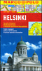


Helsinki City Map & Guide
Helsinki on a laminated, waterproof and tear-resistant street plan from Karttakeskus combining a street plan of the city with a detailed enlargement of its town centre, plus a road map of the capital’s environs, a diagram of the tram network, and brief descriptions of 30 most interesting sights prominently highlighted on the plans.Helsinki’s central districts are shown on an indexed street plan at 1:15, 000, indicating tram lines with route numbers, metro stations, taxi ranks, one way streets, car parks and petrol stations, ferry terminals, selected hotels, etc. Streets are annotated with selected house numbers for easier identification of addresses. The city centre around the railway station is also shown in much greater detail at 1:5, 000. 30 of the city’s most
interesting places are prominently marked and cross-referenced to brief descriptions accompanied by small colour photos. The plans are accompanied by a large, clear diagram of Helsinki’s tram network, plus a road map showing the capital’s environs at 1:100, 000. Map legend and all the text include English.The map can be customised with suitable marker pens, and is laminated in a way similar to the old cloth-dissected maps, so that sections of it can be easily viewed without damaging the whole sheet.
interesting places are prominently marked and cross-referenced to brief descriptions accompanied by small colour photos. The plans are accompanied by a large, clear diagram of Helsinki’s tram network, plus a road map showing the capital’s environs at 1:100, 000. Map legend and all the text include English.The map can be customised with suitable marker pens, and is laminated in a way similar to the old cloth-dissected maps, so that sections of it can be easily viewed without damaging the whole sheet.
Product Description
Reviews/Comments
Add New
Vouchers
No voucher codes found.
Do you know a voucher code for this product or supplier? Add it to Insights for others to use.
Do you know a voucher code for this product or supplier? Add it to Insights for others to use.
 Denmark