More From Contributor
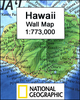
£18.99
Hawaii in the Frommer's Day By Day series is a pocket-sized guide ideal for short trips, covering a variety of budgets. The best sights of each destination are listed in convenient full-day tours for one, two or three days such as: thematic tours for interests including art, architecture & history are described, allowing you to get the most out of your time; walking tours take you around each destination ...
Archived Product
£11.99
Hawaii in the Diving & Snorkeling series from Lonely Planet; exploring the diving opportunities in a range of popular international diving sites. Frank & informal in style, the guides offer practical advice to travelers on specific diving holidays or those wanting to dive or snorkel while away. The guides offer practical advice on a large number of diving sites in the region & are suitable for advanced divers & novices alike. Widely recognized for their reliability, each Lonely Planet Diving & Snorkeling guide has the same layout. Extensive introductory chapters cover facts about the region, including history, geography & language, practical guidance on what to bring, the rating system for dives & divers, ...
Archived Product
£6.99
Hawaii East-to-Read map from Rand Mc Nally showing the islands on separate panels but all at the same scale of 1:260, 000 approx, with enlargements for Honolulu & Vicinity, Hilo, Kahului – Wailuku area, & the Hawaii Volcanoes National Park. The islands are presented on four separate panels: Oahu, Hawaii (The Big Island), Kauai with Niihau, plus Maui with Molokai, Lanai & Kahoolawe. Cartography differs from Rand Mc Nally’s standard presentation in state maps, with bold altitude colouring & relief shading to show each island’s topography. Road network indicates unpaved roads & 4-WD tracks. National/state parks & forests are marked & symbols indicate various places of interest including campsites & beaches. The maps have no geographical coordinates. The index

Includes::
separate lists of places of interest such as beaches, craters & parks. Also provided is a mileage chart, plus a map of the whole Hawaii archipelago including the islands of the Papahanaumokuakea Marine National Monument from Nihoa to the Midway Islands. For the specifications of other Rand Mc Nally state maps please click on the series link.

...
Archived Product
£14.99
Hawaii Eyewitness travel guide from Dorling Kindersley is a lavishly illustrated book concerned with providing the visitor with detailed background information to sightseeing in the country & a broad cultural introduction. Popular historical buildings & museums are often described with cutaway diagrams allowing you to view ...
Archived Product
£7.99
Quick to read, light to carry with expert advice in all price ranges, Frommer's Easy Guide to Hawaii 2014 is the complete up-to-date reference for travelers who want to maximize their stay in the smartest, most efficient way. With Frommer's trademark candid & accessible expertise, this invaluable guide offers reviews in a wide array of choices available including lodging, sightseeing, shopping, dining & entertainment. It

Includes::
insider tips on how to tackle this vast nation, based on time constraints & interests, complete with practical advice & suggested itineraries. With user-friendly features it offers tips on excellent values, special moments, traveling with kids & overrated experiences &

Includes::
advice on getting married & honeymooning.


...
Archived Product
£16.99
Hawaii ranks among the most alluring places on earth on account of its idyllic climate & timeless landscapes. From Honolulu`s mix of sophistication & easy living to the majestic mountain ranges & pristine beaches beyond, the islands offer the perfect mix of relaxation & adventure. Insight Guide Hawaii is an indispensable guide to this land of epic scenery, thrilling outdoor experiences & fascinating cultural diversity, accompanied by stunning travel photography. Be inspired by our Best of Hawaii section highlighting unmissable sights & experiences & lavish Photo Features on the exquisite art of lei-making, volcanoes & ancient sites. With a longer & more in-depth history & culture section than its competitors, this travel guide provides an essential introduction to Hawaiian music & hula, the changes brought by Captain Cook`s arrival & the history of Hawaii`s monarchy. A detailed Places section, with full-color maps, guides you around each of the islands, starting in Honolulu, the capital of Oahu, & finishing up on the beautiful & remote island of Kauai. A comprehensive Travel Tips section gives you all the travel advice you need to plan your trip. The selective listings for hotels & restaurants are the personal recommendations of a regional specialist. Ed. September 2014. ...
Archived Product
£5.99
Havana in the Everyman Map Guide series; comprising a range of practical guide books incorporating large scale maps to a number of international cities & regions. Including a unique binding method, each district, neighbourhood, area or region has an accompanying fold-out page with a large scale overview map which is fully indexed. Each Map Guide also has details of more than 100 shops, restaurants, bars, clubs, markets & other local attractions, in addition to more practical guidance, listed underneath & on the reverse of the fold-out map. All of the main attractions also have accompanying illustrations, & there are also transport maps & a street index to help visitors find their way around. ...
Archived Product
£10.99
Hawaii Wall Map at 1:773, 000 from the National Geographic Society, size 88 x 57.5cm (35” x 22.5” approx) with a vivid presentation of the topography of the islands & the sea floor of the Pacific Ocean. An inset shows the whole Hawaiian archipelago, from Hawaii (the Big Island) itself in the east to Kure Atoll in the Northwestern Hawaiian Islands Coral Reef Ecosystem Reserve. Presentation of the larger islands on the main map, from Hawaii to Niihau, very effectively uses relief shading to show the volcanoes, indicating areas of lava flow. The islands have numerous spot heights (in feet) & plenty of names of geographical features, particularly along the coast. The surrounding seas are coloured to indicate the Hawaiian Ridge on which the islands sit & the sea floor. On individual islands the map shows main towns & villages, principal roads & airports. Latitude & longitude lines are drawn at 1° intervals. The inset shows the whole of the Hawaiian Archipelago, with additional arrows indicating trade winds & ocean currents. The accompanying notes explain the administrative status, i.e. the state of Hawaii does not include the Midway Islands which are administered by the US Navy. ...
Archived Product
£4.99
Hawaii in the Pocket Guide series from Berlitz; a collection of handy, pocket-sized guides dedicated to an extensive range of cities, regions & countries worldwide. Written in narrative form, individual guides explore the history, main sights & attractions, food & drink, accommodation & local culture of the destination in detail. Each Berlitz pocket guide has a similar format, with colour-coded sections helping readers locate information quickly in addition to distinctive chapters exploring the city or region. An introduction outlines the destination for visitors & a section dedicated to 'A Brief History' actually explores the area in relative depth. A where to go chapter is organized by region & city & is written in prose form with references to individual sites highlighted in bold for clarity. There are also further suggestions on where & when to eat. Recommendations for leisure activities in the region, including sport, nightlife & shopping, are also provided & tailored accordingly for each destination. Handy travel tips are listed alphabetically in a dedicated section, providing practical guidance & helping visitors make the most of their stay. The main hotels, particularly for cities, are also listed in an accommodation section, offering a brief overview with approximate price bandings & relevant contact details. ...
Archived Product

Hawaii Flexi Map

Hawaii on a laminated, tear-resistant Insight Flexi Map, with a street plan of central Honolulu and extensive tourist information. All the islands are shown in separate panels, with Hawaii (The Big Island) at 1:350, 000 and the remaining islands, Maui, Oahu, Kauai, Molokai, Niihau, Lanai and Kahoolawe at 1:270, 000. Also provided is a small overview map of the whole archipelago.Topography is shown by relief shading with names of various mountain groups, peaks and spot heights. On Hawaii Island various lava flows are annotated with dates of eruptions. National parks and other protected areas are highlighted.The maps show the islands
RIP - This product is no longer available on our network. It was last seen on 25.09.2019

This page now acts as a permanent archive for this product. Add more information using the comments box below to ensure it can still be found by future generations.

Use our search facility to see if it is available from an alternative contributor.
  • Availability: Out Of Stock
  • Supplier: Stanfords
  • SKU: 9789814137706
Availability: In Stock
£4.99

Product Description

Hawaii on a laminated, tear-resistant Insight Flexi Map, with a street plan of central Honolulu & extensive tourist information. All the islands are shown in separate panels, with Hawaii (The Big Island) at 1:350, 000 & the remaining islands, Maui, Oahu, Kauai, Molokai, Niihau, Lanai & Kahoolawe at 1:270, 000. Also provided is a small overview map of the whole archipelago. Topography is shown by relief shading with names of various mountain groups, peaks & spot heights. On Hawaii Island various lava flows are annotated with dates of eruptions. National parks & other protected areas are highlighted. The maps show the islands

Reviews/Comments

Add New

Price History

Vouchers

No voucher codes found.
Do you know a voucher code for this product or supplier? Add it to Insights for others to use.

Facebook

Jargon Buster

Small - something that takes up less space than normal.
Resistant - Something that can repel against something.
Laminated - A thin layer of plastic that gives a coating and shine to a material.

Supplier Information

Stanfords
Stanfords was established in 1853 and opened their iconic Covent Garden flagship store in 1901. They have become the top retailer of maps, travel books and accessories in the UK and arguably offer the largest selection of maps and travel books worldwide. Famous names such as Captain Robert Falcon Scott, Ranulph Fiennes and Michael Palin have purchased from Stanfords. They now have a shop in Bristol and both stores together with other venues operate a calendar of events including talks, book signings and exhibitions. As a specialist map retailer, the map selection is comprehensive and includes road maps, street maps and walking maps from worldwide destinations, as well as a selection of world atlases and wall maps. Books include travel guides and travel literature. Stanfords also stock globes, from miniatures made of blue marble to magnificent floor-standing globes. The website features a selection of interesting articles on travel topics.
Page Updated: 2023-11-12 20:15:36

Community Generated Product Tags

Fleximap honolulu (1 person tagged the product this way)
Menu