
 United Kingdom
 France
 Germany
 Netherlands
 Sweden
 USA
USA
 Italy
Italy
 Spain
Spain
More From Contributor


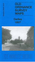
Gatley 1897
Gatley in 1897 in a fascinating series of reproductions of old Ordnance Survey plans in the Alan Godfrey Editions, ideal for anyone interested in the history of their neighbourhood or family. Selected towns in Great Britain and Ireland are covered by maps showing the extent of urban development in the last decades of the 19th and early 20th century.In this title: the map is double-sided. The main map covers Gatley, Gatley Green and the western part of Cheadle, together with Sharston Mount. Coverage stretches from St Mary's church Cheadle westward to Northenden station. Please note that the Lancashire area north of the Mersey is left blank on this map. Features include stretches of LNWR and Cheshire Lines railways, with eastern end of Northenden station; Barnes Convalescent Hospital,
Cheadle Bleach Works, St Mary's church, Greenhall Bridge, Gatley Old Hall, St James church Gatley, Sharston Hall, Royle Green (in the north-western corner of map). On the reverse are an extract from adjacent sheet 18.04, extending coverage westward to Lower Haveleyhey and including Sharston Green. About the Alan Godfrey Editions of the 25
Cheadle Bleach Works, St Mary's church, Greenhall Bridge, Gatley Old Hall, St James church Gatley, Sharston Hall, Royle Green (in the north-western corner of map). On the reverse are an extract from adjacent sheet 18.04, extending coverage westward to Lower Haveleyhey and including Sharston Green. About the Alan Godfrey Editions of the 25
Product Description
Reviews/Comments
Add New
Intelligent Comparison
Archived Product
Gatley 1897 Stanfords
£3.50
Archived Product
Batley 1892 Stanfords
£2.95
Archived Product

Batley 1892 Stanfords
£3.50
Archived Product

Sale 1897 Stanfords
£3.50
Archived Product

Batley 1905 Stanfords
£3.50
Archived Product
Battle 1937 Stanfords
£3.50
Vouchers
No voucher codes found.
Do you know a voucher code for this product or supplier? Add it to Insights for others to use.
Do you know a voucher code for this product or supplier? Add it to Insights for others to use.
 Denmark