More From Contributor
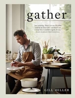
£2.50
Gateshead street map from Nicolson Maps; coverage

Includes::
Byker, Dunston, Felling, Hebburn, Pelaw,

...
Archived Product
£3.50
Gateshead East in 1895 in a fascinating series of reproductions of old Ordnance Survey plans in the Alan Godfrey Editions, ideal for anyone interested in the history of their neighbourhood or family. The map of Gateshead East stretches from Moratio Street & St Anthony`s Vicarage in the north to Sunderland Road & Brewery Lane in the south. Features include Friars Goose Chemical Works, St Peters Works, Allhusen Chemical Works, St Patricks RC Chapel, Birds Nest Quarry, part of the North Eastern Railway Works, showing the Engine Sheds & Goods Sheds & Portland Cement Works. On the reverse is a directory for the area with three illustrations
- Fell Street, Newcastle Quayside & River Police Station. About the Alan Godfrey Editions of the 25” OS Series: Selected towns in Great Britain & Ireland are covered by maps showing the extent of urban development in the last decades of the 19th & early 20th century. The plans have been taken from the Ordnance Survey mapping & reprinted at about 15 inches to one mile (1:4, 340). On the reverse most maps have historical notes & many also include extracts from contemporary directories. Most maps cover about one mile (1.6kms) north/south, one & a half miles (2.4kms) across; adjoining sheets can be combined to provide wider coverage.FOR MORE INFORMATION & A COMPLETE LIST OF ALL AVAILABLE TITLES PLEASE CLICK ON THE SERIES LINK.
...
Archived Product
£2.95
Gateshead Fell & Sheriff Hill in 1895 in a fascinating series of reproductions of old Ordnance Survey plans in the Alan Godfrey Editions, ideal for anyone interested in the history of their neighbourhood or family. Selected towns in Great Britain & Ireland are covered by maps showing the extent of urban development in the last decades of the 19th & early 20th century. In this title: the map covers the Gateshead Fell area, south of Gateshead & east of Low Fell. The ' Old Durham Road', Sodhouse Bank runs through the map. Coverage stretches from St Albans church at Windy Nook southward to Mossheap Quarries & the disused Sheriff Hill Colliery. Stretches of the Team Colliery Wagonway & Ouston & Pelaw Wagonway are shown. Other features include Beacon Lough, Church Quarry, Windynook Quarries, Gateshead High Fell with St John's church, the eastern part of Kells Lane, Greenwell House, Heworth Windmill, White Hill, Black Hill. Old Upper Heworth Colliery is in the north-eastern corner. Extracts from directories are included, together with portraits of Alexander Gillies & his niece Mrs Wicks, mayor & mayoress of Gateshead in 1902. About the Alan Godfrey Editions of the 25 ...
Archived Product
£3.50
Gateshead South in 1894 in a fascinating series of reproductions of old Ordnance Survey plans in the Alan Godfrey Editions, ideal for anyone interested in the history of their neighbourhood or family. The map covers Bensham, Teams & Shipcote. Features include Saltwell Park, Gateshead Union Workhouse, Bensham Brick Works, St Paul`s Church, Bensham Hall, Christ Church, NER railway Line & Bensham Station, High Team Bridge, Nanny Rawley`s Wood & Bensham Tower. On the reverse is an extract from from a directory of 1894. About the Alan Godfrey Editions of the 25” OS Series: Selected towns in Great Britain & Ireland are covered by maps showing the extent of urban development in the last decades of the 19th & early 20th century. The plans have been taken from the Ordnance Survey mapping & reprinted at about 15 inches to one mile (1:4, 340). On the reverse most maps have historical notes & many also include extracts from contemporary directories. Most maps cover about one mile (1.6kms) north/south, one & a half miles (2.4kms) across; adjoining sheets can be combined to provide wider coverage.FOR MORE INFORMATION & A COMPLETE LIST OF ALL AVAILABLE TITLES PLEASE CLICK ON THE SERIES LINK. ...
Archived Product
£2.95
Gathurst & Crooke in 1907 in a fascinating series of reproductions of old Ordnance Survey plans in the Alan Godfrey Editions, ideal for anyone interested in the history of their neighbourhood or family. Selected towns in Great Britain & Ireland are covered by maps showing the extent of urban development in the last decades of the 19th & early 20th century. In this title: the map covers the Gathurst & Crooke area, west of Wigan; coverage stretches from Crooke westward to Dean Cottages, & from John Pit Colliery southward to Ackhurst Hall. Features include LYR Wigan-Southport line with Gathurst station, Branckers Siding, mineral railway to canal, Leeds & Liverpool Canal, River Douglas, Crooke village, Crooke Hall, Otters Croft Wood, remains of Tunnel Canal, John Pit colliery with mineral railway, John Pit Houses, Gathurst Mount, Roburite Explosives Works & tramways, Ackhurst Hall, Gathurst Fold, Milk House Cottage, Dean Locks, Gathurst Farm. About the Alan Godfrey Editions of the 25 ...
Archived Product
£3.50
Gathurst & Crooke in 1907 in a fascinating series of reproductions of old Ordnance Survey plans in the Alan Godfrey Editions, ideal for anyone interested in the history of their neighbourhood or family. The map covers the Gathurst & Crooke area, west of Wigan; coverage stretches from Crooke westward to Dean Cottages, & from John Pit Colliery southward to Ackhurst Hall. Features include LYR Wigan-Southport line with Gathurst station, Branckers Siding, mineral railway to canal, Leeds & Liverpool Canal, River Douglas, Crooke village, Crooke Hall, Otters Croft Wood, remains of Tunnel Canal, John Pit colliery with mineral railway, John Pit Houses, Gathurst Mount, Roburite Explosives Works & tramways, Ackhurst Hall, Gathurst Fold, Milk House Cottage, Dean Locks, Gathurst Farm, etc. About the Alan Godfrey Editions of the 25” OS Series: Selected towns in Great Britain & Ireland are covered by maps showing the extent of urban development in the last decades of the 19th & early 20th century. The plans have been taken from the Ordnance Survey mapping & reprinted at about 15 inches to one mile (1:4, 340). On the reverse most maps have historical notes & many also include extracts from contemporary directories. Most maps cover about one mile (1.6kms) north/south, one & a half miles (2.4kms) across; adjoining sheets can be combined to provide wider coverage.FOR MORE INFORMATION & A COMPLETE LIST OF ALL AVAILABLE TITLES PLEASE CLICK ON THE SERIES LINK. ...
Archived Product
£7.99
Double-sided, indexed street plan of Gatineau. Street plans from the Map Art / Canadian Cartographics Corporation / JDM Géo publishing group are usually produced at scales around 1:25, 000 to 1:35, 000 with smaller towns often shown at more detailed scales. All plans have street indexes. Plans of larges cities usually include an enlargement for the downtown area. Plans grouping together several smaller towns often have an overview map showing the whole of the relevant region. The plans have colouring to indicate commercial, institutional or industrial use, etc. Main traffic arteries are highlighted & one way streets are marked. A range of symbols shows, as appropriate, parking facilities, bus terminals, metro and/or railway stations, various public facilities & services, places of interest, recreational centres, etc. Map legends for cities & towns in the French speaking part of the country are sometimes in French only. To see the list of currently available Canadian street plans & pocket atlases form the Map Art / Canadian Cartographics Corporation / JDM Géo publishing group, including waterproof & tear-resistant Fast Track titles, please click on the series link. ...
Archived Product
£2.95
Gatley in 1897 in a fascinating series of reproductions of old Ordnance Survey plans in the Alan Godfrey Editions, ideal for anyone interested in the history of their neighbourhood or family. Selected towns in Great Britain & Ireland are covered by maps showing the extent of urban development in the last decades of the 19th & early 20th century. In this title: the map is double-sided. The main map covers Gatley, Gatley Green & the western part of Cheadle, together with Sharston Mount. Coverage stretches from St Mary's church Cheadle westward to Northenden station. Please note that the Lancashire area north of the Mersey is left blank on this map. Features include stretches of LNWR & Cheshire Lines railways, with eastern end of Northenden station; Barnes Convalescent Hospital, Cheadle Bleach Works, St Mary's church, Greenhall Bridge, Gatley Old Hall, St James church Gatley, Sharston Hall, Royle Green (in the north-western corner of map). On the reverse are an extract from adjacent sheet 18.04, extending coverage westward to Lower Haveleyhey & including Sharston Green. About the Alan Godfrey Editions of the 25 ...
Archived Product
£3.50
Gatley in 1897 in a fascinating series of reproductions of old Ordnance Survey plans in the Alan Godfrey Editions, ideal for anyone interested in the history of their neighbourhood or family. The map is double-sided. The main map covers Gatley, Gatley Green & the western part of Cheadle, together with Sharston Mount. Coverage stretches from St Mary`s church Cheadle westward to Northenden station. Please note that the Lancashire area north of the Mersey is left blank on this map. Features include stretches of LNWR & Cheshire Lines railways with eastern end of Northenden station, Barnes Convalescent Hospital, Cheadle Bleach Works, St Mary`s church, Greenhall Bridge, Gatley Old Hall, St James church Gatley, Sharston Hall, Royle Green (in the north-western corner of map), etc. On the reverse is an extract from adjacent sheet 18.04, extending coverage westward to Lower Haveleyhey & Sharston Green. About the Alan Godfrey Editions of the 25” OS Series: Selected towns in Great Britain & Ireland are covered by maps showing the extent of urban development in the last decades of the 19th & early 20th century. The plans have been taken from the Ordnance Survey mapping & reprinted at about 15 inches to one mile (1:4, 340). On the reverse most maps have historical notes & many also include extracts from contemporary directories. Most maps cover about one mile (1.6kms) north/south, one & a half miles (2.4kms) across; adjoining sheets can be combined to provide wider coverage.FOR MORE INFORMATION & A COMPLETE LIST OF ALL AVAILABLE TITLES PLEASE CLICK ON THE SERIES LINK. ...
Archived Product

Gather

Gather is a cookbook that celebrates simplicity and nature, both in ingredients and cooking styles. Head Chef at River Cottage for 10 years, Gill Meller showcases 120 brand new recipes inspired by the landscapes in which he lives and works. Featuring chapters on foods from Moorland (game and herbs), Garden (tomatoes, salads, soft fruits), Farm (pork, dairy, honey), Field (rye, barley, wheat, oats), Seashore (crab, seaweed, oysters), Orchard (apples, pears, cherries), Harbour (fish and seafood), and Woodland (mushrooms, damsons, blackberries), Gill gently guides the reader through simple recipes, with no need for obscure ingredients or complicated cooking.With great food at its heart, Gather is the most contemporary of cookbooks, with photography that captures a
year of the best cooking and eating.
RIP - This product is no longer available on our network. It was last seen on 25.09.2019

This page now acts as a permanent archive for this product. Add more information using the comments box below to ensure it can still be found by future generations.

Use our search facility to see if it is available from an alternative contributor.
  • External links may include paid for promotion
  • Availability: Out Of Stock
  • Supplier: Stanfords
  • SKU: 9781849497138
Availability: In Stock
£25.00

Product Description

Gather is a cookbook that celebrates simplicity & nature, both in ingredients & cooking styles. Head Chef at River Cottage for 10 years, Gill Meller showcases 120 brand new recipes inspired by the landscapes in which he lives & works. Featuring chapters on foods from Moorland (game & herbs), Garden (tomatoes, salads, soft fruits), Farm (pork, dairy, honey), Field (rye, barley, wheat, oats), Seashore (crab, seaweed, oysters), Orchard (apples, pears, cherries), Harbour (fish & seafood), & Woodland (mushrooms, damsons, blackberries), Gill gently guides the reader through simple recipes, with no need for obscure ingredients or complicated cooking. With great food at its heart, Gather is the most contemporary of cookbooks, with photography that captures a year of the best cooking & eating.

Reviews/Comments

Add New

Intelligent Comparison

Oooops!
We couldn't find anything!
Perhaps this product's unique.... Or perhaps we are still looking for comparisons!
Click to bump this page and we'll hurry up.

Price History

Vouchers

No voucher codes found.
Do you know a voucher code for this product or supplier? Add it to Insights for others to use.

Facebook

Jargon Buster

Contemporary - Modern era design
Honey - A sweet produce made by honey bees in their hives from pollen and nectar from flowers
Contemporary - A design reference to indicate post war modern design
Garden - An outside area with grass and foliage
garden - A planned space used for the display, cultivation and enjoyment of plants and other forms of nature.
soft - A descriptive word for an item/sound which is gentle to the touch or ears
Year - The time it takes the planet earth to orbit the sun. This takes around 365.25 days.
Heart - An organ that pumps blood around the body. Usually related to love.
Fish - A creature that lives in water. A fish uses gills to breath unlike mammals
Contemporary - An object that is living in the same time.
Simple - Basic, easy no difficulty in understanding.
Year - 365 days (366 days in a leap year), the time taken for planet earth to make one full revolution around the sun.
Cottage - A house typically found in the country, commonly small in size.
Head - The upper part of a body typically separated by the neck.

Supplier Information

Stanfords
Stanfords was established in 1853 and opened their iconic Covent Garden flagship store in 1901. They have become the top retailer of maps, travel books and accessories in the UK and arguably offer the largest selection of maps and travel books worldwide. Famous names such as Captain Robert Falcon Scott, Ranulph Fiennes and Michael Palin have purchased from Stanfords. They now have a shop in Bristol and both stores together with other venues operate a calendar of events including talks, book signings and exhibitions. As a specialist map retailer, the map selection is comprehensive and includes road maps, street maps and walking maps from worldwide destinations, as well as a selection of world atlases and wall maps. Books include travel guides and travel literature. Stanfords also stock globes, from miniatures made of blue marble to magnificent floor-standing globes. The website features a selection of interesting articles on travel topics.
Page Updated: 2023-11-12 20:15:36

Community Generated Product Tags

Oh No! The productWIKI community hasn't generated any tags for this product yet!
Menu