More From Contributor
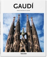
£7.99
Double-sided, indexed street plan of Gatineau. Street plans from the Map Art / Canadian Cartographics Corporation / JDM Géo publishing group are usually produced at scales around 1:25, 000 to 1:35, 000 with smaller towns often shown at more detailed scales. All plans have street indexes. Plans of larges cities usually include an enlargement for the downtown area. Plans grouping together several smaller towns often have an overview map showing the whole of the relevant region. The plans have colouring to indicate commercial, institutional or industrial use, etc. Main traffic arteries are highlighted & one way streets are marked. A range of symbols shows, as appropriate, parking facilities, bus terminals, metro and/or railway stations, various public facilities & services, places of interest, recreational centres, etc. Map legends for cities & towns in the French speaking part of the country are sometimes in French only. To see the list of currently available Canadian street plans & pocket atlases form the Map Art / Canadian Cartographics Corporation / JDM Géo publishing group, including waterproof & tear-resistant Fast Track titles, please click on the series link. ...
Archived Product
£2.95
Gatley in 1897 in a fascinating series of reproductions of old Ordnance Survey plans in the Alan Godfrey Editions, ideal for anyone interested in the history of their neighbourhood or family. Selected towns in Great Britain & Ireland are covered by maps showing the extent of urban development in the last decades of the 19th & early 20th century. In this title: the map is double-sided. The main map covers Gatley, Gatley Green & the western part of Cheadle, together with Sharston Mount. Coverage stretches from St Mary's church Cheadle westward to Northenden station. Please note that the Lancashire area north of the Mersey is left blank on this map. Features include stretches of LNWR & Cheshire Lines railways, with eastern end of Northenden station; Barnes Convalescent Hospital, Cheadle Bleach Works, St Mary's church, Greenhall Bridge, Gatley Old Hall, St James church Gatley, Sharston Hall, Royle Green (in the north-western corner of map). On the reverse are an extract from adjacent sheet 18.04, extending coverage westward to Lower Haveleyhey & including Sharston Green. About the Alan Godfrey Editions of the 25 ...
Archived Product
£3.50
Gatley in 1897 in a fascinating series of reproductions of old Ordnance Survey plans in the Alan Godfrey Editions, ideal for anyone interested in the history of their neighbourhood or family. The map is double-sided. The main map covers Gatley, Gatley Green & the western part of Cheadle, together with Sharston Mount. Coverage stretches from St Mary`s church Cheadle westward to Northenden station. Please note that the Lancashire area north of the Mersey is left blank on this map. Features include stretches of LNWR & Cheshire Lines railways with eastern end of Northenden station, Barnes Convalescent Hospital, Cheadle Bleach Works, St Mary`s church, Greenhall Bridge, Gatley Old Hall, St James church Gatley, Sharston Hall, Royle Green (in the north-western corner of map), etc. On the reverse is an extract from adjacent sheet 18.04, extending coverage westward to Lower Haveleyhey & Sharston Green. About the Alan Godfrey Editions of the 25” OS Series: Selected towns in Great Britain & Ireland are covered by maps showing the extent of urban development in the last decades of the 19th & early 20th century. The plans have been taken from the Ordnance Survey mapping & reprinted at about 15 inches to one mile (1:4, 340). On the reverse most maps have historical notes & many also include extracts from contemporary directories. Most maps cover about one mile (1.6kms) north/south, one & a half miles (2.4kms) across; adjoining sheets can be combined to provide wider coverage.FOR MORE INFORMATION & A COMPLETE LIST OF ALL AVAILABLE TITLES PLEASE CLICK ON THE SERIES LINK. ...
Archived Product
£6.50
Topographic coverage of mainland Spain at 1:25, 000 published by the Centro Nacional de Información Geograficá, the country’s civilian survey organization. The maps have contours at 10m intervals & colouring and/or graphics to show different types of vegetation or land use. Boundaries of national parks & other protected areas are marked. In addition to all the usual information shown on topographic maps at this scale, detailed presentation of the road & rail networks, rural tracks & paths, etc, the maps also show campsites. The maps have a 1-km UTM grid, with margin ticks for latitude & longitude at 1` intervals. Map legend is in Spanish only.PLEASE NOTE: our grid for the whole of Spain is in preparation
- in the meantime, for areas other than those shown on the attached grid please use CNIG’s topographic survey at 1:50, 000 by searching for ‘SI00000832’. Each 25K map covers one quarter of the corresponding 50K map, with the numbering system: I = NW quarter, II = NE quarter, III = SW quarter & IV = SE quarter. CNIG maps in the Provincial Road Maps series at 1:200, 000 are overprinted with the grid for the 1:50, 000 survey & can be used to see the area covered by each 50K or 25K title in more detail. To see the list of titles in this series please click on the series grid
- for map numbers not yet listed on our website please contact us by email.

...
Archived Product
£7.99
The complete works of the great Antoni Gaudi (TASCHEN`s 25th anniversary special edition) Anyone who visits Barcelona today will come across the works of Antoni Gaudi
- the architect who has attracted art-lovers from all over the world to Spain, it was here, in the capital of Catalonia, that the famous master of architecture produced nearly all of his works, including villas for the well-to-do bourgeoisle, the expansive Guell Park (which today is open to the public), & the famous church designed in honour of the Holy Family
- a project which was begun over 100 years ago & has yet to be completed. Antoni Gaudi`s life was full of contradictions. As a young man he joined the Catalonian nationalist movement & was critical of the church; toward the end of his life he devoted himself completely to the construction of one single church. As a young man Gaudi had a liking for the glamour of social life & the looks of a dandy; in old age, on the other h&, he lived a spartan life. Gaudi never married & devoted his life entirely to his art: architecture. His works have been acclaimed as ”soothing oases in a desert of functional buildings, ” as ”precious gems in the uniform grey of rows of houses, ” & the master himself was acclaimed as the ” Dante of architecture”. This book provides a sweeping study of his entire career, presenting his complete works via texts & illustrations.

...
Archived Product
£7.95
Antoni Gaudi & his inimitable fluid, organic style, is inextricably linked with the city of Barcelona. His spectacular buildings
-
...
Archived Product
£5.95
Map of the National Park with enlarged scale insets of key areas & towns within the park. Detail

Includes::


...
Archived Product
£22.99
This Gaularfjellet National Tourist Route Map belongs to a series of 18 map & postcards sets describing popular tourist routes all over Norway. The map set

Includes::
a map in 1: 50, 000 presenting an accurate topography (based on the Norwegian topographic survey) which describes local footpaths, cycle or ski routes, sport & recreational facilities, places of interest, places to stay & eat, viewpoints. Gaularfjellet National Tourist Route is a 130-kilometre-long stretch of road between Balestrand in Sogn & Moskog & Sande in Sunnfjord in the county of Sogn og Fjordane in Fjord Norway. The protected Gaular Watercourse, with its many lively rapids, waterfalls & shining lakes, is like a row of pearls along Gaularfjellet National Tourist Route. The drive is exciting & varied, along narrow fjords, on twisting roads up steep mountainsides, over high mountains & back down sheltered valleys. The route offers a peaceful alternative to the main roads between Sogn & Sunnfjord. Here children & adults can experience trout fishing at its best & wander on good paths beside waterfalls & rapids. It is also possible to rent a boat or take a walk in the mountains. In Balestrand there are museums & galleries & a wide selection of services. There is one panoramic view & rest area: Likholefossen features a parking lot, small rest area & a footbridge across one of the many rapids in the Gaula River. From the bridge you can walk along the ”river path” skirting the protected river. The set
Features: One map: scale 1:50, 000 Text in three languages (Norwegian, English & German)5 Postcards (13.5x 25cm) To see the list of other titles in this series, please click on the series link.


...
Archived Product
£11.99
Ardennes Recreational Maps at a scale of 1:25, 000 enable you to discover the Ardennes from junction to junction, each associated with a locality, through a network of hiking, cycling or riding paths. The network of mini walks consists of suggested routes with kilometre distance marked showing field boundaries & urbanised built up areas. Contour markings are at five metre intervals. The map legend is in English, French, Dutch & German. You can scan QR codes on the map for details about the respective locality or upload GPX files of the proposed routes via the provided website. ...
Archived Product
£9.99
Gaurishankar Himal, sheet no. 2786-02, in the topographic survey of Nepal at 1:50, 000 published by the Nepali Government in the late 1990s & early 2000s & produced from remote sensing data by Finnish cartographers as part of that country’s international aid program. The maps cover 15’ x 15’ quadrangles.IMPORTANT – PLEASE NOTE BEFORE ORDERING: AVAILABILITY: although, theoretically at least, still in print, these maps are very difficult to get locally in Nepal and/or from various suppliers elsewhere specializing in obtaining such maps. DELIVERIES MAY TAKE SEVERAL WEEKS OR EVEN MONTHS.PROBLEMS WITH PLACE NAMES: reports from previous users indicate that transliteration of place names differs from that used widely not only on other maps & in guide books but also on the ground itself, in road signs & in the tourist & trekking industry in general. Whilst most names are similar enough to be easily recognizable, e.g. Namche Bajar for Namche Bazar or Lantan for Langtang, we have been told of confusion & difficulties arising from different spellings appearing on these maps.TREKKING ROUTES & TOURIST INFORMATION: whilst the maps show foot trails & mark locations of temples, etc, they carry no specific trekking information. Major trekking routes & places of interest are not highlighted. There is no marking for base camps & other tourist facilities. Map specifications: Contours are at 40m intervals, with graphics and/or coloring to show various features of the terrain (glaciers with moraines & crevasses, quarries, gravel or clay pits, etc.) & vegetation (forests, bush, grass, orchards & plantations, etc). Additional comments such as “open mixed forest mainly bajh & pine” annotate many area. The maps have numerous spot heights, but relatively few peaks are named. Areas outside the country’s borders are left blank. Settlements in remote areas are indicated by markings for individual buildings & the placing of names does not always make it clear which group of buildings they refer to. Road network distinguishes between major & minor foot trails. Symbols mark features such as temples, schools & hospitals, police stations, etc. Also shown are the country’s administrative divisions. The maps have a 1-km UTM grid, plus latitude & longitude lines at intervals of 5’. Map legend & all the text is in English. Coverage: the whole country is now covered, with the north at 1:50, 000, plus central & southern Nepal at 1:25, 000. The two series are complementary, do not overlap & use the same grid & numbering system (apart from the Lumbini Zone, where a different grid & numbering are used). For areas not shown on our grid & titles not listed here, please contact us by e-mail, but please do bear in mind the problems with availability & the likely very long delivery time. ...
Archived Product

Gaudi

Wherever they go, anyone who visits Barcelona today will come across the works of Spanish architect Antoni Gaudi (1852-1926), the architect who has attracted art-lovers from all over the world to Spain. It was there, in the capital of Catalonia, that the famous master of architecture produced nearly all of his works. Raised during the Industrial Revolution, Gaudi strove to distinguish and reaffirm the identity of his native Catalonia as Spain and the rest of Europe modernized. Early neo-Gothic designs were the stepping-stone to the mature, original style that came to be synonymous with his name. Incorporating bold colors and odd bits of material into his designs, Gaudi created inspiring, visionary buildings and helped establish Barcelona (most notably with the still-unfinished
Sagrada Familia cathedral) as a city of the world.
RIP - This product is no longer available on our network. It was last seen on 25.09.2019

This page now acts as a permanent archive for this product. Add more information using the comments box below to ensure it can still be found by future generations.

Use our search facility to see if it is available from an alternative contributor.
  • External links may include paid for promotion
  • Availability: Out Of Stock
  • Supplier: Stanfords
  • SKU: 9783836560283
Availability: In Stock
£9.99

Product Description

Wherever they go, anyone who visits Barcelona today will come across the works of Spanish architect Antoni Gaudi (1852-1926), the architect who has attracted art-lovers from all over the world to Spain. It was there, in the capital of Catalonia, that the famous master of architecture produced nearly all of his works. Raised during the Industrial Revolution, Gaudi strove to distinguish & reaffirm the identity of his native Catalonia as Spain & the rest of Europe modernized. Early neo-Gothic designs were the stepping-stone to the mature, original style that came to be synonymous with his name. Incorporating bold colors & odd bits of material into his designs, Gaudi created inspiring, visionary buildings & helped establish Barcelona (most notably with the still-unfinished Sagrada Familia cathedral) as a city of the world.

Reviews/Comments

Add New

Intelligent Comparison

Oooops!
We couldn't find anything!
Perhaps this product's unique.... Or perhaps we are still looking for comparisons!
Click to bump this page and we'll hurry up.

Price History

Vouchers

No voucher codes found.
Do you know a voucher code for this product or supplier? Add it to Insights for others to use.

Facebook

Jargon Buster

Spain - A country within the EU.
Spanish - The main language spoken in Spain and Latin America.
World - A physical grouping, commonly used to describe earth and everything associated with ti
Stone - Or Rock is a naturally occuring mineral categorised into three types, Igneous, Sedimentary and Metamorphic
Synonymous - A word that has a similar meaning to another.

Supplier Information

Stanfords
Stanfords was established in 1853 and opened their iconic Covent Garden flagship store in 1901. They have become the top retailer of maps, travel books and accessories in the UK and arguably offer the largest selection of maps and travel books worldwide. Famous names such as Captain Robert Falcon Scott, Ranulph Fiennes and Michael Palin have purchased from Stanfords. They now have a shop in Bristol and both stores together with other venues operate a calendar of events including talks, book signings and exhibitions. As a specialist map retailer, the map selection is comprehensive and includes road maps, street maps and walking maps from worldwide destinations, as well as a selection of world atlases and wall maps. Books include travel guides and travel literature. Stanfords also stock globes, from miniatures made of blue marble to magnificent floor-standing globes. The website features a selection of interesting articles on travel topics.
Page Updated: 2023-11-12 20:15:36

Community Generated Product Tags

Oh No! The productWIKI community hasn't generated any tags for this product yet!
Menu