
 United Kingdom
 France
 Germany
 Netherlands
 Sweden
 USA
USA
 Italy
Italy
 Spain
Spain
More From Contributor


Congo DR & Central African Republic ITMB
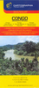
The Congos (Congo-Brazzaville and the Democratic Republic of Congo) plus Central African Republic at 1:2, 000, 000 on an indexed, double-sided map from ITMB with a very large number of place names of small towns and villages.The map divides the region north/south with no overlap between the sides. The easternmost parts of the DRC: north of Lake Albert and along Lake Tanganyika, plus the westernmost regions of both Congos with Cabinda are shown as insets. Topography is presented by altitude colouring and spot heights in feet. The map does show numerous tributaries of the Congo, although not always with names.Road network indicates paved and unpaved roads, includes selected local tracks, gives driving distances on main routes, and shows locations of fuel supplies and birder crossings.
Railway lines are included and domestic airports and landing grounds are marked. Also shown are ferry routes on Lake Tanganyika and Lake Kivu, as well as ports on the Congo.Compared with other titles, the map shows an exceptionally large number of villages, although many with neither a local track nor a river connection. The map also indicates locations with tourist accommodation and various facilities including hospitals and dispensaries, as well as places of interest. Latitude and longitude lines are drawn at 1° intervals.Please note: given the large number of place names, the print size for many locations and throughout the index is relatively small.
Railway lines are included and domestic airports and landing grounds are marked. Also shown are ferry routes on Lake Tanganyika and Lake Kivu, as well as ports on the Congo.Compared with other titles, the map shows an exceptionally large number of villages, although many with neither a local track nor a river connection. The map also indicates locations with tourist accommodation and various facilities including hospitals and dispensaries, as well as places of interest. Latitude and longitude lines are drawn at 1° intervals.Please note: given the large number of place names, the print size for many locations and throughout the index is relatively small.

Product Description
Reviews/Comments
Add New
Intelligent Comparison
Archived Product

Central African Republic Stanfords
£10.99
Archived Product

Flag Of Central African Republic Stanfords
£8.99
Vouchers
No voucher codes found.
Do you know a voucher code for this product or supplier? Add it to Insights for others to use.
Do you know a voucher code for this product or supplier? Add it to Insights for others to use.
 Denmark