
 United Kingdom
 France
 Germany
 Netherlands
 Sweden
 USA
USA
 Italy
Italy
 Spain
Spain
More From Contributor


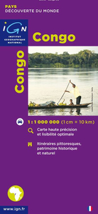
Congo (Brazzaville)
Congo (Brazaville) on a road map from the IGN in Paris, with relief shading and colouring/graphics indicating different types of vegetaion and terrain: forest, grassland, marches, areas liable to flooding. Road and rail connections are shown, with a separate distance table between main centres of population. A large diagram shows the administrative divisions of the country. Latitude and longitude are shown in the margins at 1 degree intervals. The legend is in French only.*PLEASE NOTE:*The map also shows the grid for the 1:200, 000 topographic survey of Congo prepared by IGN mostly in the 1950s and 1960s. Detailed topographic maps of France`s ex-colonies are now available only as reproductions from the IGN library, and in many cases special permits from the relevant African
governments are needed to purchase them. Costs vary, but are always considerably higher than for current topographic maps of this kind. In any enquiries please indicate full sheet numbers and titles, e.g. Sibiti, SA-33-XX.
governments are needed to purchase them. Costs vary, but are always considerably higher than for current topographic maps of this kind. In any enquiries please indicate full sheet numbers and titles, e.g. Sibiti, SA-33-XX.
 "Pin It")
Product Description
Reviews/Comments
Add New
Vouchers
No voucher codes found.
Do you know a voucher code for this product or supplier? Add it to Insights for others to use.
Do you know a voucher code for this product or supplier? Add it to Insights for others to use.
 Denmark