More From Contributor

£9.99
Congo Democratic Republic on a map published by Belgium’s national survey organization in 1988. A plain white base shows the country’s network of rivers & lakes, with additional graphics for marshlands. Navigable stretches of larger rivers are marked. The map shows road & rail networks, as well as internal administrative boundaries. There is no information outside the country’s borders beyond names of nearby capital cities. The map has latitude & longitude grid at intervals of 2º, with additional margin ticks at 1º. Map legend is in French only. ...
Archived Product
£9.99
The Congos (Congo-Brazzaville & the Democratic Republic of Congo) plus Central African Republic at 1:2, 000, 000 on an indexed, double-sided map from ITMB with a very large number of place names of small towns & villages. The map divides the region north/south with no overlap between the sides. The easternmost parts of the DRC: north of Lake Albert & along Lake Tanganyika, plus the westernmost regions of both Congos with Cabinda are shown as insets. Topography is presented by altitude colouring & spot heights in feet. The map does show numerous tributaries of the Congo, although not always with names. Road network indicates paved & unpaved roads,

Includes::
selected local tracks, gives driving distances on main routes, & shows locations of fuel supplies & birder crossings. Railway lines are included & domestic airports & landing grounds are marked. Also shown are ferry routes on Lake Tanganyika & Lake Kivu, as well as ports on the Congo. Compared with other titles, the map shows an exceptionally large number of villages, although many with neither a local track nor a river connection. The map also indicates locations with tourist accommodation & various facilities including hospitals & dispensaries, as well as places of interest. Latitude & longitude lines are drawn at 1° intervals. Please note: given the large number of place names, the print size for many locations & throughout the index is relatively small.

...
Archived Product
£18.99
Combining the acute observation of a nineteenth-century missionary, & the wit of a Monty Python player, Redmond O` Hanlon is famous for his adventurous travel. In Congo Journey his challenge is the Congo, the most dangerous & inhospitable jungle in the world. How does it feel to have 22 million ants wanting to share your bed? What is it like when the village chief plots your execution even as he drinks your whisky? The answers to these & other questions are provided by Redmond O` Hanlon in this brilliant book. ...
Archived Product
£7.99
Congo Journey combines the acute observation of a nineteenth-century missionary, & the wit of a Monty Python player, Redmond O' Hanlon is famous for his adventurous travel. In Congo Journey his challenge is the Congo, the most dangerous & inhospitable jungle in the world. ...
Archived Product
£10.50
Democratic Republic of Congo (Kinshasa) & the Republic of Congo (Brazzaville) on light, waterproof & tear-resistant map providing both topographic & tourist information. The map, published by Reise Know-How as part of their highly acclaimed World Mapping Project, is double-sided to provide the best balance between a good scale & a convenient size sheet. Topography is shown by altitude colouring with contours, spot heights, names of mountain ranges in the interior, seasonal rivers & swamps. Road network

Includes::
local roads & 4WD tracks, shows driving distances on main routes & indicates locations of fuel supplies & border crossings. Railways, local airfields, ports along the Congo & its tributaries, & ferry connections of Lake Tanganyika & Lake Kivu are marked. Internal administrative boundaries are shown with names of the provinces. Coverage

Includes::
the whole of Rwanda & Burundi. National parks & protected areas are marked & symbols indicate locations with hotel accommodation, various places of interest, natural gas fields, etc. The map has a grid with latitude & longitude at intervals of 1º, & an extensive index of localities. Map legend

Includes::
English.


...
Archived Product
£13.99
Congost de Mont-rebei in an extensive & very popular series of walking maps from Editorial Alpina covering the Pyrenees, Catalonia & other selected hiking areas in Spain, including Picos de Europa, Sierra Nevada & parts of Andalucía, Majorca, etc. Scales vary from 1:50, 000 to 1:10, 000, with the majority of the titles at 1:25, 000. The maps have contours, usually at 20m or 10m intervals, with additional hill shading & spot heights. An overprint highlights hiking trails, long-distance footpaths, campsites, mountain huts, refuges, etc. Many maps also show climbing sites, potholing caves, mountain bike routes, equestrian & ski centres. All the latest editions have a UTM grid, plus margin ticks for latitude & longitude at intervals of 1’. Map legend in most titles

Includes::
English. Each title has a separate booklet with general information on the area, descriptions of selected hiking routes, a list of accommodation with addresses, etc. In several titles the booklet now

Includes::
English.* In this title:* Contours at 10m intervals, relief shading & vegetation colouring. UTM grid & 1’ margin ticks. In addition to footpaths, the overprint shows various types of accommodation (hotels, campsites, refuges, etc.), information centres, places of interest, via ferrata routes, paragliding sites, locations of petrol stations on local roads, etc. Map legend & the booklet with descriptions of the area & various routes include English.


...
Archived Product
£9.95
Conguillio Region at 1:100, 000 in a series of contoured, GPS compatible trekking & exploration maps at various scales form Trekkingchile, printed on sturdy, waterproof & tear-resistant plastic paper. Recreational maps from Trekkingchile are annotated with tourist information & most titles include a street plan of the region ...
Archived Product
£6.50
Topographic coverage of mainland Spain at 1:25, 000 published by the Centro Nacional de Información Geograficá, the country’s civilian survey organization. The maps have contours at 10m intervals & colouring and/or graphics to show different types of vegetation or land use. Boundaries of national parks & other protected areas are marked. In addition to all the usual information shown on topographic maps at this scale, detailed presentation of the road & rail networks, rural tracks & paths, etc, the maps also show campsites. The maps have a 1-km UTM grid, with margin ticks for latitude & longitude at 1` intervals. Map legend is in Spanish only.PLEASE NOTE: our grid for the whole of Spain is in preparation
- in the meantime, for areas other than those shown on the attached grid please use CNIG’s topographic survey at 1:50, 000 by searching for ‘SI00000832’. Each 25K map covers one quarter of the corresponding 50K map, with the numbering system: I = NW quarter, II = NE quarter, III = SW quarter & IV = SE quarter. CNIG maps in the Provincial Road Maps series at 1:200, 000 are overprinted with the grid for the 1:50, 000 survey & can be used to see the area covered by each 50K or 25K title in more detail. To see the list of titles in this series please click on the series grid
- for map numbers not yet listed on our website please contact us by email.

...
Archived Product
£3.50
Conisbrough in 1901 in a fascinating series of reproductions of old Ordnance Survey plans in the Alan Godfrey Editions, ideal for anyone interested in the history of their neighbourhood or family. The map covers the historic town of Conisbrough with its great castle, which inspired Walter Scott`s novel Ivanhoe. Most of the town is covered, including the castle itself, St Peter`s church, Burcroft, New Hill & (on a small backing map extending coverage south) Holywell Hill, Lime Grove & Holywell Brewery. The main map extends west to Denaby Main village, including All Saints church & the eastern part of Denaby Main Colliery (the rest is on sheet 284.09). The GCR Barnsley to Barnetby line runs through the map, with Conisbrough station & sidings to Providence Glass Works. Near to it is the Denaby terminus of the South Yorkshire Junction Railway. About the Alan Godfrey Editions of the 25” OS Series: Selected towns in Great Britain & Ireland are covered by maps showing the extent of urban development in the last decades of the 19th & early 20th century. The plans have been taken from the Ordnance Survey mapping & reprinted at about 15 inches to one mile (1:4, 340). On the reverse most maps have historical notes & many also include extracts from contemporary directories. Most maps cover about one mile (1.6kms) north/south, one & a half miles (2.4kms) across; adjoining sheets can be combined to provide wider coverage.FOR MORE INFORMATION & A COMPLETE LIST OF ALL AVAILABLE TITLES PLEASE CLICK ON THE SERIES LINK. ...
Archived Product
£8.99
This is a field guide to the relics of copper mining in the fells above Coniston, at Tilberthwaite, Greenburn & at Seathwaite Tarn above the Duddon Valley. Because of opportunities these old mines present for the study of industrial archaeology, for adventure, mineral collecting & geology there is an ever-increasing awareness of them among widely varying sections of the public. One could say a new sport has come into being as more & more people of all age groups, not contenting themselves solely with surface exploration & fossicking in old dumps, are going below ground. Mining did not cease completely in the region until 1942, having commenced at Coniston in or around 1599. Evidence of working from the earliest times right through to the 1950s are to be seen at Coniston, thus creating a unique memorial to the immense endeavour which has taken place both on & under these fells. ...
Archived Product

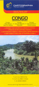
Congo, Democratic Republic

Detailed road map with an inset showing a street plan of the central part of Kinshasa. Relief shading shows the topography. Six different types of roads and tracks are shown, indicating those passable only in the dry season, with intermediate driving distances on main roads. The map also shows railways, airports and ports, river navigational limits and shipping routes on Lake Tanganika. National parks and game reserves, waterfalls and reservoirs, dams, caves, mangroves and volcanoes are also marked, as well as various religious establishments, monuments, viewpoints and tourist sites, beaches and campsites, etc.An inset shows a street plan of the central part of Kinshasa, with a note that some street names are subject to change. Index of place names is printed on the reverse
of the map. Longitude and latitude lines are drawn at 2° intervals. Map legend includes English.
RIP - This product is no longer available on our network. It was last seen on 25.09.2019

This page now acts as a permanent archive for this product. Add more information using the comments box below to ensure it can still be found by future generations.

Use our search facility to see if it is available from an alternative contributor.
  • External links may include paid for promotion
  • Availability: Out Of Stock
  • Supplier: Stanfords
  • SKU: 9789633529751
Availability: In Stock
£8.99

Product Description

Detailed road map with an inset showing a street plan of the central part of Kinshasa. Relief shading shows the topography. Six different types of roads & tracks are shown, indicating those passable only in the dry season, with intermediate driving distances on main roads. The map also shows railways, airports & ports, river navigational limits & shipping routes on Lake Tanganika. National parks & game reserves, waterfalls & reservoirs, dams, caves, mangroves & volcanoes are also marked, as well as various religious establishments, monuments, viewpoints & tourist sites, beaches & campsites, etc. An inset shows a street plan of the central part of Kinshasa, with a note that some street names are subject to change. Index of place names is printed on the reverse of the map. Longitude & latitude lines are drawn at 2° intervals. Map legend

Includes::
English.

Reviews/Comments

Add New

Intelligent Comparison

Oooops!
We couldn't find anything!
Perhaps this product's unique.... Or perhaps we are still looking for comparisons!
Click to bump this page and we'll hurry up.

Price History

Vouchers

No voucher codes found.
Do you know a voucher code for this product or supplier? Add it to Insights for others to use.

Facebook

Jargon Buster

Dry - A term used to describe an item with has little or no water present
Dry - A term used in wine making to describe the lack of sugar (sweetness)
Railways - A set of tracks that have been laid for the purpose of trains to travel up and down them
Road - a manmade lane or a path that is used to speed up travel.
Season - The separation of four parts of the year into Spring, Summer, Autumn, Winter.

Supplier Information

Stanfords
Stanfords was established in 1853 and opened their iconic Covent Garden flagship store in 1901. They have become the top retailer of maps, travel books and accessories in the UK and arguably offer the largest selection of maps and travel books worldwide. Famous names such as Captain Robert Falcon Scott, Ranulph Fiennes and Michael Palin have purchased from Stanfords. They now have a shop in Bristol and both stores together with other venues operate a calendar of events including talks, book signings and exhibitions. As a specialist map retailer, the map selection is comprehensive and includes road maps, street maps and walking maps from worldwide destinations, as well as a selection of world atlases and wall maps. Books include travel guides and travel literature. Stanfords also stock globes, from miniatures made of blue marble to magnificent floor-standing globes. The website features a selection of interesting articles on travel topics.
Page Updated: 2023-11-12 20:15:36

Community Generated Product Tags

Oh No! The productWIKI community hasn't generated any tags for this product yet!
Menu