
 United Kingdom
 France
 Germany
 Netherlands
 Sweden
 USA
USA
 Italy
Italy
 Spain
Spain
More From Contributor


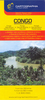


Congo Republic & DR Congo Reise Know-How
Democratic Republic of Congo (Kinshasa) and the Republic of Congo (Brazzaville) on light, waterproof and tear-resistant map providing both topographic and tourist information. The map, published by Reise Know-How as part of their highly acclaimed World Mapping Project, is double-sided to provide the best balance between a good scale and a convenient size sheet.Topography is shown by altitude colouring with contours, spot heights, names of mountain ranges in the interior, seasonal rivers and swamps. Road network includes local roads and 4WD tracks, shows driving distances on main routes and indicates locations of fuel supplies and border crossings. Railways, local airfields, ports along the Congo and its tributaries, and ferry connections of Lake Tanganyika and Lake Kivu are
marked. Internal administrative boundaries are shown with names of the provinces. Coverage includes the whole of Rwanda and Burundi. National parks and protected areas are marked and symbols indicate locations with hotel accommodation, various places of interest, natural gas fields, etc. The map has a grid with latitude and longitude at intervals of 1º, and an extensive index of localities. Map legend includes English.
marked. Internal administrative boundaries are shown with names of the provinces. Coverage includes the whole of Rwanda and Burundi. National parks and protected areas are marked and symbols indicate locations with hotel accommodation, various places of interest, natural gas fields, etc. The map has a grid with latitude and longitude at intervals of 1º, and an extensive index of localities. Map legend includes English.

Product Description
Reviews/Comments
Add New
Vouchers
No voucher codes found.
Do you know a voucher code for this product or supplier? Add it to Insights for others to use.
Do you know a voucher code for this product or supplier? Add it to Insights for others to use.
 Denmark