More From Contributor
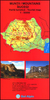
£3.50
Brymbo in 1909 in a fascinating series of reproductions of old Ordnance Survey plans in the Alan Godfrey Editions, ideal for anyone interested in the history of their neighbourhood or family. Tthe map covers the industrial village of Brymbo, just north-west of Wrexham. Brymbo Hall is near the centre of the map & coverage stretches from Smelt Wood eastward to Cefn, & from The Green southward to Ty-cerryg. The Brymbo Steel Works is a major feature surrounded by much of the village of Brymbo, including St John`s church (at top of map), Tai, Brymbo Colliery, The Green, & many railway tracks. The various (and confusing!) railways include GWR Wrexham & Minera line with The Lodge Halt, GCR Brymbo Branch with terminus, GCR Vron Branch & GWR Vron Branch. Other features include Phosphate Works, Black Lane Colliery, Offa`s Dike, several old mine shafts, etc. Communities or areas include The Lodge, Cefn, Pen-rhos. On the reverse is a directory of Brymbo with railway timetables for the Wrexham-Berwig Halt line & Brymbo & Coed Talon Branch. About the Alan Godfrey Editions of the 25” OS Series: Selected towns in Great Britain & Ireland are covered by maps showing the extent of urban development in the last decades of the 19th & early 20th century. The plans have been taken from the Ordnance Survey mapping & reprinted at about 15 inches to one mile (1:4, 340). On the reverse most maps have historical notes & many also include extracts from contemporary directories. Most maps cover about one mile (1.6kms) north/south, one & a half miles (2.4kms) across; adjoining sheets can be combined to provide wider coverage.FOR MORE INFORMATION & A COMPLETE LIST OF ALL AVAILABLE TITLES PLEASE CLICK ON THE SERIES LINK. ...
Archived Product
£3.50
Brynmawr in 1915 in a fascinating series of reproductions of old Ordnance Survey plans in the Alan Godfrey Editions, ideal for anyone interested in the history of their neighbourhood or family. The map covers the town of Brynmawr, extending southward to Winchestown & the northern part of Nantyglo. Features include Market Square, Newtown, Twyn-Cynnordy, Town Hall, Market Hall, St Mary`s RC chapel, boot factory, other chapels, Clydachbridge, banks, football ground, etc. The main LNWR & GWR Joint Railway is shown with station, a section of the Brynmawr & Blaenavon branch, mineral lines; also Twyn Blaen-nant, Twyn-blaen-nant, Mynydd Rheinallt, Blean-nant Colliery, Nantyglo Slope Colliery, Cwm Crachen, Twyn-y-deryn, Cokeyard Colliery (disused), Lion Tin Plate Works, Llyn Colliery, reservoir, etc. On the reverse is a directory of Brynmawr, plus a railway timetable for the Brynmawr-Newport line in 1906. This map also

Includes::
a portion of Monmouthshire (sheet 11.07) About the Alan Godfrey Editions of the 25” OS Series: Selected towns in Great Britain & Ireland are covered by maps showing the extent of urban development in the last decades of the 19th & early 20th century. The plans have been taken from the Ordnance Survey mapping & reprinted at about 15 inches to one mile (1:4, 340). On the reverse most maps have historical notes & many also include extracts from contemporary directories. Most maps cover about one mile (1.6kms) north/south, one & a half miles (2.4kms) across; adjoining sheets can be combined to provide wider coverage.FOR MORE INFORMATION & A COMPLETE LIST OF ALL AVAILABLE TITLES PLEASE CLICK ON THE SERIES LINK.

...
Archived Product
£8.95
In the last decade, advances made in observational instruments & computational techniques have allowed astronomers to look both deeper into space &, by implication, further back into time to construct new scenarios for the probable beginning & possible end of the cosmos. Ironically, each new discovery, while revealing intricate details, has also posed new questions. People have always speculated on the nature of the universe, pondering its origin, evolution & eventual fate. In this volume, six leading cosmologists provide a current `state of the universe` report: what we have learned about its nature
- but also what pieces are still missing from the cosmic puzzle. Taken in toto their contributions provide a stimulating addition to the field.
...
Archived Product
£6.99
Sailing across the Caribbean, Hector Lynch falls into the hands of the notorious buccaneer, Captain John Coxon. Hector's two friends, Dan & Jacques, are released when Coxon mistakes Hector as the nephew of Sir Thomas Lynch the Governor of Jamaica
- an error that Hector encourages. Coxon delivers Hector to Sir Henry Morgan, a bitter enemy of Governor Lynch. The captain is expecting to curry favour with Henry Morgan but is publicly humiliated at a Christmas ball held in Morgan's grand Jamaican home when it is revealed that Hector is not a member of the Governor's family. From then on, Coxon seeks to revenge himself on Hector & the young seafarer finds himself on the run again. On his new journey he falls in love for the first time, gets caught in a deadly hurricane & merely survives another shipwreck. Eventually he teams up again with his old friends Dan, Jacques & the group joins an expedition along the Panama coast. Their aim is to raid one of the biggest Spanish gold mines, but their plans are soon interfered by some angry Spaniards & their clash has even more dramatic consequences.
...
Archived Product
£8.50
This map of the Selkirk & Hawick areas
- the heart of Britain's horse-riding country
- has been specially produced for horse

...
Archived Product
£6.00
Bucegi Mountains at 1:50, 000 on a contoured map from Bel Alpin, highlighting local waymarked hiking routes, listed on the reverse side with markings & timings, plus a street plan of Sinaia showing locations of hotels. The map shows the topography by contours at 100m intervals & additional colouring for woodlands. An overprint highlights hiking routes, indicating their waymarking signs & cross-referencing them to a list of 47 routes on the reverse side. Also marked are mountain huts, churches & monasteries, etc. The map has no geographical coordinates. Map legend

Includes::
English. Half of the reverse side it taken by English language information about the area, including lists of accommodation facilities. 47 routes are listed with their marking signs & timings, including where appropriate warnings against attempting the route in bad weather conditions or in winter.

...
Archived Product
£8.50
The city with its suburbs & an enlargement for the centre. Coverage extends from Lacul Pantelimon in the east to Lacul Moril in the west, & from Lacul Grivita in the north to the Buna Vestire cemetery in the south. Detail

Includes::
car parks, petrol stations, metro & railway lines & stations, parks, cemeteries, police stations, hospitals, monuments, museums, public buildings industrial areas & places of worship. An inset at 1:10, 000 shows the city centre in greater detail. Map legend

Includes::
English. Street index is on the reverse of the map.


...
Archived Product
£7.99
Plan of the city with its outer suburbs, showing administrative districts. An enlargement at 1:10, 000 shows the centre, a diagram shows the metro network, & a road map at 1:300, 000 covers the environs of the capital. Both the main plan & the enlargement show bus, trolleybus, tram, metro & railway lines. A range of symbols denotes important buildings, churches, hotels, shopping centres, museums, campsites, police stations, hospitals, etc. Street index is on the reverse. Map legend

Includes::
English.

...
Archived Product
£4.99
Handy size plan of the city with its inner suburbs at 1:20, 000 & an enlargement for the central part at 1:15, 000. Underground & tram lines & stations are highlighted, alongside notable buildings & places of interest. A range of symbols denotes many specific features e.g. churches, hotels, markets, filling stations, museums, car parks, hospitals. Many locations are numbered & listed, together with the street index, on the reverse. Map legend

Includes::
English.

...
Archived Product
£6.99
This is the savvy city breakers' pocket guide to seeing & doing more in the Romanian capital
- with a fun-seeking & cost-conscious
...
Archived Product

Bucegi Mountains

Bucegi Mountains at 1:50, 000 on a contoured map highlighting hiking routes, with a street plan of Sinaia showing tourist accommodation. Topography is shown by contours at 100m intervals with additional colouring for woodlands. An overprint highlights hiking routes, indicating their waymarking signs. Also marked are mountain huts. The map has no geographical coordinates. Map legend includes English.On the reverse are notes on the area, lists of mountain shelters, plus descriptions of 33 routes - all in Romanian only.
RIP - This product is no longer available on our network. It was last seen on 25.09.2019

This page now acts as a permanent archive for this product. Add more information using the comments box below to ensure it can still be found by future generations.

Use our search facility to see if it is available from an alternative contributor.
  • External links may include paid for promotion
  • Availability: Out Of Stock
  • Supplier: Stanfords
  • SKU: 9789738788596
Availability: In Stock
£6.00

Product Description

Bucegi Mountains at 1:50, 000 on a contoured map highlighting hiking routes, with a street plan of Sinaia showing tourist accommodation. Topography is shown by contours at 100m intervals with additional colouring for woodlands. An overprint highlights hiking routes, indicating their waymarking signs. Also marked are mountain huts. The map has no geographical coordinates. Map legend

Includes::
English. On the reverse are notes on the area, lists of mountain shelters, plus descriptions of 33 routes
- all in Romanian only.

Reviews/Comments

Add New

Intelligent Comparison

Oooops!
We couldn't find anything!
Perhaps this product's unique.... Or perhaps we are still looking for comparisons!
Click to bump this page and we'll hurry up.

Price History

Vouchers

No voucher codes found.
Do you know a voucher code for this product or supplier? Add it to Insights for others to use.

Facebook

Jargon Buster

Hiking - An outdoor activity envolving walking in nature
Accommodation - A room in which someone can live in, for example in a hotel

Supplier Information

Stanfords
Stanfords was established in 1853 and opened their iconic Covent Garden flagship store in 1901. They have become the top retailer of maps, travel books and accessories in the UK and arguably offer the largest selection of maps and travel books worldwide. Famous names such as Captain Robert Falcon Scott, Ranulph Fiennes and Michael Palin have purchased from Stanfords. They now have a shop in Bristol and both stores together with other venues operate a calendar of events including talks, book signings and exhibitions. As a specialist map retailer, the map selection is comprehensive and includes road maps, street maps and walking maps from worldwide destinations, as well as a selection of world atlases and wall maps. Books include travel guides and travel literature. Stanfords also stock globes, from miniatures made of blue marble to magnificent floor-standing globes. The website features a selection of interesting articles on travel topics.
Page Updated: 2023-11-12 20:15:36

Community Generated Product Tags

9789738788596 (1 person tagged the product this way)
Menu