
 United Kingdom
 France
 Germany
 Netherlands
 Sweden
 USA
USA
 Italy
Italy
 Spain
Spain
More From Contributor


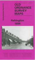
Ashington 1896
Ashington in 1896 in a fascinating series of reproductions of old Ordnance Survey plans in the Alan Godfrey Editions, ideal for anyone interested in the history of their neighbourhood or family. Selected towns in Great Britain and Ireland are covered by maps showing the extent of urban development in the last decades of the 19th and early 20th century.In this title: the map shows the mining village of Ashington, considered a model pit village when founded in the 1860s. Ashington Colliery is in the centre and below this are the neat rows of terraces, named 'First Row' up to 'Ninth Row'. These all faced south and had long gardens. South of these are St Sepulchre's church, Portland Arms Hotel, Miners Hall and Market Place (effectively a street). To the east is the NER line with Ashington
station, and beyond this the map covers part of New Hirst. However, the notable feature of this map is the tramway system, a network of track which was ultimately around ten miles long which served virtually every street and house, horse drawn trucks delivering coal and collecting refuse and night soil. These tracks are shown here in detail, both in Ashington and New Hirst. On the reverse is part of sheet 65.09, extending coverage eastward to Woodhorn Colliery. About the Alan Godfrey Editions of the 25
station, and beyond this the map covers part of New Hirst. However, the notable feature of this map is the tramway system, a network of track which was ultimately around ten miles long which served virtually every street and house, horse drawn trucks delivering coal and collecting refuse and night soil. These tracks are shown here in detail, both in Ashington and New Hirst. On the reverse is part of sheet 65.09, extending coverage eastward to Woodhorn Colliery. About the Alan Godfrey Editions of the 25
Product Description
Reviews/Comments
Add New
Intelligent Comparison
Archived Product
Ashington 1896 Stanfords
£3.50
Archived Product
Washington 1896 Stanfords
£2.95
Archived Product

Washington 1896 Stanfords
£3.50
Archived Product

Kensington 1894 Stanfords
£3.50
Archived Product
Alston 1898 Stanfords
£2.95
Archived Product
Alston 1898 Stanfords
£3.50
Archived Product
Orpington 1868 Stanfords
£3.50
Vouchers
No voucher codes found.
Do you know a voucher code for this product or supplier? Add it to Insights for others to use.
Do you know a voucher code for this product or supplier? Add it to Insights for others to use.
 Denmark