
 United Kingdom
 France
 Germany
 Netherlands
 Sweden
 USA
USA
 Italy
Italy
 Spain
Spain
More From Contributor


Washington 1896
Washington in 1896 in a fascinating series of reproductions of old Ordnance Survey plans in the Alan Godfrey Editions, ideal for anyone interested in the history of their neighbourhood or family. Selected towns in Great Britain and Ireland are covered by maps showing the extent of urban development in the last decades of the 19th and early 20th century.In this title: the map is double-sided. The main map covers the area west of the village, a semi-rural landscape which includes Old Washington, the Washington Wagonway, Brandy Row and Washington Colliery. Wagonman's Row is at the top of the map. The map extends west across Washington Moor to High Washington, Havannah Terrace and the terrace known as New York. On the reverse is a large part of adjacent sheet 7.15 and this includes the
actual village of Washington with Old Hall, Holy Trinity church, Dame Margaret's Home, RC church. The hamlet known as New Washington is at the top of the map. At the extreme right is a section of the Leamside & Ferryhill railway line with Usworth station. About the Alan Godfrey Editions of the 25
actual village of Washington with Old Hall, Holy Trinity church, Dame Margaret's Home, RC church. The hamlet known as New Washington is at the top of the map. At the extreme right is a section of the Leamside & Ferryhill railway line with Usworth station. About the Alan Godfrey Editions of the 25
Product Description
Reviews/Comments
Add New
Intelligent Comparison
Archived Product

Washington 1896 Stanfords
£3.50
Archived Product
Ashington 1896 Stanfords
£2.95
Archived Product
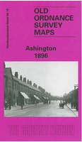
Ashington 1896 Stanfords
£3.50
Archived Product
Washington Stanfords
£8.50
Archived Product
Washington DC Stanfords
£8.95
Archived Product

Washington DC Stanfords
£6.99
Archived Product
Washington DC Stanfords
£10.39
Archived Product
Washington DC Stanfords
£4.99
Vouchers
No voucher codes found.
Do you know a voucher code for this product or supplier? Add it to Insights for others to use.
Do you know a voucher code for this product or supplier? Add it to Insights for others to use.
 Denmark