
 United Kingdom
 France
 Germany
 Netherlands
 Sweden
 USA
USA
 Italy
Italy
 Spain
Spain
More From Contributor
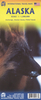

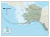

Alaska NGS Wall Map PAPER
Alaska physical wall map, size 103 x 78cm (40.5” x 31” approx) – paper version, at 1:3, 660, 000 from the National Geographic, with colouring to show the topography and plenty of place names. Coverage includes the panhandle and the outermost Aleutian Islands in their proper geographical placing.Altitude colouring and relief shading shows the topography, with names of mountain ranges, peaks with heights (in feet), etc. Boundaries of national parks and other protected areas are marked. The map shows Alaska’s road network, the railway line from Anchorage to Fairbanks, numerous local airfields with scheduled air or seaplane services, and ferry routes. The map has a very large number of place names: towns and settlements, geographical features including islands, bays, etc.On
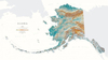
the surrounding seas ocean floor is shown in relief with sounding (also in feet). Latitude and longitude lines are drawn at 5° intervals. An inset shows the conterminous part of USA with Alaska and the Aleutian Islands superimposed on it to indicate the size ot the state: from the southern tip of the panhandle to the Attu Island equals Jacksonville in Florida to San Francisco!This title is also available encapsulated.
the surrounding seas ocean floor is shown in relief with sounding (also in feet). Latitude and longitude lines are drawn at 5° intervals. An inset shows the conterminous part of USA with Alaska and the Aleutian Islands superimposed on it to indicate the size ot the state: from the southern tip of the panhandle to the Attu Island equals Jacksonville in Florida to San Francisco!This title is also available encapsulated.

Product Description
Reviews/Comments
Add New
Vouchers
No voucher codes found.
Do you know a voucher code for this product or supplier? Add it to Insights for others to use.
Do you know a voucher code for this product or supplier? Add it to Insights for others to use.
 Denmark