
 United Kingdom
 France
 Germany
 Netherlands
 Sweden
 USA
USA
 Italy
Italy
 Spain
Spain
More From Contributor


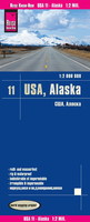
Alaska Reise Know-How
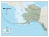
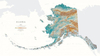
Alaska at 1:2, 000, 000 in a series of waterproof and tear-resistant, indexed regional maps of USA from Reise Know-How’s highly acclaimed World Mapping Project, combining detailed presentation of the road network with topographic and tourist information. The map is double-sided to provide the best balance between detailed scale and a convenient size sheet. Coverage includes the whole of the Aleutian Islands, with Near and Rat Islands and the panhandle shown as insets. The map presents a very good picture of the states topography with plenty of names of geographical features. National parks and other protected areas are listed in a separate index.Maps in this series have altitude colouring with spot heights to show each region’s topography, with national parks and other protected
areas, as well as American Indian Reservations and restricted entry zones clearly marked. Road network indicates toll roads and scenic routes. Driving distances are shown in miles. Railways and, where appropriate, ferry routes are marked. The maps show both names and boundaries of local counties. Symbols highlight a variety of places of interest, including historical sites, amusement parks, natural features, golf courses and wintersport areas, etc. Each map includes an index of localities and has a latitude and longitude grid (in this title at intervals of 2°). Map legend includes English.To see other titles in this series please click on the series link.
areas, as well as American Indian Reservations and restricted entry zones clearly marked. Road network indicates toll roads and scenic routes. Driving distances are shown in miles. Railways and, where appropriate, ferry routes are marked. The maps show both names and boundaries of local counties. Symbols highlight a variety of places of interest, including historical sites, amusement parks, natural features, golf courses and wintersport areas, etc. Each map includes an index of localities and has a latitude and longitude grid (in this title at intervals of 2°). Map legend includes English.To see other titles in this series please click on the series link.

Product Description
Reviews/Comments
Add New
Vouchers
No voucher codes found.
Do you know a voucher code for this product or supplier? Add it to Insights for others to use.
Do you know a voucher code for this product or supplier? Add it to Insights for others to use.
 Denmark