More From Contributor

£16.99
Some call Alaska the last frontier. Go ride there & you’ll understand why. Alaska is HUGE. This map provides detailed, easy to read information specifically for motorcyclists. The most dramatic sections of paved & dirt roads are highlighted in Butler Maps popular Gold, Red & Orange colors & are accompanied by crucial information about places to eat, sleep, fuel up & cool down. You will also find detailed inset boxes showcasing Alaska’s popular highways as well as roads through Western Canada. This map was produced in conjunction with Moto Quest Tours & is a great supplement to The Adventurous Motorcyclist’s Guide to Alaska by Octane Press. ...
Archived Product
£9.99
Alaska at 1:1, 500, 000 on an indexed, double-side map from ITMB with altitude colouring to show the topography & highlighting for the state’s numerous national parks & protected areas. The main part of the state is divided north/south with a small overlap between the sides. The panhandle is shown as an inset at the same scale as the main map; Aleutian Islands are on another panel but at 1:3, 750, 000. Topography is presented by altitude colouring in broad bands, with heights for main peaks (in feet). Road network

Includes::
selected local tracks & winter only routes. Railway lines & ferry connections are included; local airports & seaplane bases are marked. Symbols indicate locations of various recreational activities & facilities. Various locations are annotated with brief historical notes. Each side of the map has a separate index. Latitude & longitude lines are drawn at 2° intervals. To see other regional titles from ITMB covering USA please click on the series link.

...
Archived Product
£7.99
Alaska in Michelin’s ‘ Must Sees’ series is a lightweight guide containing must see information, must see sights, must do activities & must know practicalities graded using Michelin’s time-honoured star rating system. The guide opens with a section of useful ‘ Must Know’ information that

Includes::
a calendar of events, practical tips on getting by & a summary of Michelin selected star attractions. The ‘ Must See’ section of the guide look at shopping, nightlife & theatre, hotels & dining, parks & gardens, neighbourhoods, landmarks, museums, historic sites, practical information, events, tips & excursions. The ‘ Must Do’ chapter

Includes::
a focus on activities for children, whereas places to eat & places to stay are reviewed in the ‘ Must Eat’ & ‘ Must Stay’ chapters.


...
Archived Product
£0.01
Physical 96x 58cm map of Alaska, encapsulated version, with an inset showing the size of the state in comaprison with the rest of the country. General relief is shown by hill-shading, & bathymetric tinting is applied to the ocean. Selected spot heights are marked, glaciers & wetland areas are indicated. Other detail

Includes::
national parks, wildlife refuges, airports, railways, roads, oilfields & pipelines. Latitude & longitude lines are drawn at 3

...
Archived Product
£9.99
Physical 96x 58cm map of Alaska, paper version, with an inset showing the size of the state in comaprison with the rest of the country. General relief is shown by hill-shading, & bathymetric tinting is applied to the ocean. Selected spot heights are marked, glaciers & wetland areas are indicated. Other detail

Includes::
national parks, wildlife refuges, airports, railways, roads, oilfields & pipelines. Latitude & longitude lines are drawn at 3

...
Archived Product
£17.99
Alaska physical wall map, size 103 x 78cm (40.5” x 31” approx) – paper version, at 1:3, 660, 000 from the National Geographic, with colouring to show the topography & plenty of place names. Coverage

Includes::
the panhandle & the outermost Aleutian Islands in their proper geographical placing. Altitude colouring & relief shading shows the topography, with names of mountain ranges, peaks with heights (in feet), etc. Boundaries of national parks & other protected areas are marked. The map shows Alaska’s road network, the railway line from Anchorage to Fairbanks, numerous local airfields with scheduled air or seaplane services, & ferry routes. The map has a very large number of place names: towns & settlements, geographical features including islands, bays, etc. On the surrounding seas ocean floor is shown in relief with sounding (also in feet). Latitude & longitude lines are drawn at 5° intervals. An inset shows the conterminous part of USA with Alaska & the Aleutian Islands superimposed on it to indicate the size ot the state: from the southern tip of the panhandle to the Attu Island equals Jacksonville in Florida to San Francisco! This title is also available encapsulated.

...
Archived Product
£4.99
Alaska in the Pocket Guide series from Berlitz; a collection of handy, pocket-sized guides dedicated to an extensive range of cities, regions & countries worldwide. Written in narrative form, individual guides explore the history, main sights & attractions, food & drink, accommodation & local culture of the destination in detail. Each Berlitz pocket guide has a similar format, with colour-coded sections helping readers locate information quickly in addition to distinctive chapters exploring the city or region. An introduction outlines the destination for visitors & a section dedicated to 'A Brief History' actually explores the area in relative depth. A where to go chapter is organized by region & city & is written in prose form with references to individual sites highlighted in bold for clarity. There are also further suggestions on where & when to eat. Recommendations for leisure activities in the region, including sport, nightlife & shopping, are also provided & tailored accordingly for each destination. Handy travel tips are listed alphabetically in a dedicated section, providing practical guidance & helping visitors make the most of their stay. The main hotels, particularly for cities, are also listed in an accommodation section, offering a brief overview with approximate price bandings & relevant contact details. ...
Archived Product
£13.99
Fodor's. For Choice Travel Experiences.
Fodor's helps you unleash the possibilities of travel by providing the insightful tools
...
Archived Product
£14.99
Alaska Recreational Atlas & Gazetteer in a series of large format paperback state atlases from De Lorme, with detailed, contoured, GPS compatible topographic mapping plus extensive recreational information. The south-eastern part of the state, including Alaska’s main national parks & protected areas, is covered at 1:300, 000, with the remainder at 1:1, 400, 000. Recreational information in this title included extensive tables of facilities found on national & state lands, lists of campgrounds, historic sites & museums, fresh or salt water fishing sites, hunting areas, boat ramps, unique natural features, wildlife refuges, etc. Also provided are indexed street plans of Anchorage, Fairbanks & Juneau, several thematic maps, temperature tables, & a mileage chart. Each title in this De Lorme series covers one state & presents it at a scale much more detailed than used on most state road maps. Particularly popular areas are often also presented on enlargements. The maps are contoured, show variation of terrain (deserts, glaciers, wetlands, woodlands, etc) & have latitude & longitude and/or UTM grid lines for GPS use. Various types of protected areas are distinguished by the colouring of their boundaries, e.g. national or state parks, forests, etc. Also marked are Indian Reservations & restricted entry military zones. Road network is shown in much more detail than on other state mapping, with local roads, unsurfaced back roads & tracks, forest trails, etc. Where appropriate, old historical routes are marked. Railway lines & local airports or landing strips are included & the maps also indicate administrative boundaries. Symbols highlight various recreational areas & facilities such as campgrounds, unique natural features, etc. Each title contains extensive lists of outdoor adventure sites (grouped into activities such as hiking, biking, paddling, fishing, skiing, etc.), diverse family outing sites, campgrounds, & tables showing what facilities can be found in the state’s recreational areas. Each atlas also has an index of localities. To see the list of titles in this series please click on the series link. ...
Archived Product
£11.50
Alaska at 1:2, 000, 000 in a series of waterproof & tear-resistant, indexed regional maps of USA from Reise Know-How’s highly acclaimed World Mapping Project, combining detailed presentation of the road network with topographic & tourist information. The map is double-sided to provide the best balance between detailed scale & a convenient size sheet. Coverage

Includes::
the whole of the Aleutian Islands, with Near & Rat Islands & the panhandle shown as insets. The map presents a very good picture of the states topography with plenty of names of geographical features. National parks & other protected areas are listed in a separate index. Maps in this series have altitude colouring with spot heights to show each region’s topography, with national parks & other protected areas, as well as American Indian Reservations & restricted entry zones clearly marked. Road network indicates toll roads & scenic routes. Driving distances are shown in miles. Railways &, where appropriate, ferry routes are marked. The maps show both names & boundaries of local counties. Symbols highlight a variety of places of interest, including historical sites, amusement parks, natural features, golf courses & wintersport areas, etc. Each map

Includes::
an index of localities & has a latitude & longitude grid (in this title at intervals of 2°). Map legend

Includes::
English. To see other titles in this series please click on the series link.


...
Archived Product

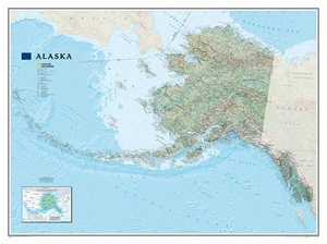
Alaska NGS Wall Map ENCAPSULATED

Alaska physical wall map, size 103 x 78cm (40.5” x 31” approx) – encapsulated version, at 1:3, 660, 000 from the National Geographic, with colouring to show the topography and plenty of place names. Coverage includes the panhandle and the outermost Aleutian Islands in their proper geographical placing.Altitude colouring and relief shading shows the topography, with names of mountain ranges, peaks with heights (in feet), etc. Boundaries of national parks and other protected areas are marked. The map shows Alaska’s road network, the railway line from Anchorage to Fairbanks, numerous local airfields with scheduled air or seaplane services, and ferry routes. The map has a very large number of place names: towns and settlements, geographical features including islands, bays,
etc.On the surrounding seas ocean floor is shown in relief with sounding (also in feet). Latitude and longitude lines are drawn at 5° intervals. An inset shows the conterminous part of USA with Alaska and the Aleutian Islands superimposed on it to indicate the size ot the state: from the southern tip of the panhandle to the Attu Island equals Jacksonville in Florida to San Francisco!This title is also available on paper. LAMINATED and ENCAPSULATED WALL MAPS:- LAMINATED wall maps have a thin layer of plastic usually applied to the printed side only. They can be written on with suitable marker pens without any damage to the map but, unless laminated on both sides, they are not damp-proof.- ENCAPSULATED wall maps are sealed between two sheets of plastic. They are more rigid and heavier
than laminated maps of the same size. They are damp-proof and do not crinkle in humid conditions. Encapsulation gives the map a shiny surface, similar to being displayed behind glass.- PLEASE NOTE: many publishers and retailers often use these two terms interchangeably. Our map titles and descriptions follow the definitions provided above
RIP - This product is no longer available on our network. It was last seen on 25.09.2019

This page now acts as a permanent archive for this product. Add more information using the comments box below to ensure it can still be found by future generations.

Use our search facility to see if it is available from an alternative contributor.
  • Availability: Out Of Stock
  • Supplier: Stanfords
  • SKU: 9781597754118
Availability: In Stock
£33.99

Product Description

Alaska physical wall map, size 103 x 78cm (40.5” x 31” approx) – encapsulated version, at 1:3, 660, 000 from the National Geographic, with colouring to show the topography & plenty of place names. Coverage

Includes::
the panhandle & the outermost Aleutian Islands in their proper geographical placing. Altitude colouring & relief shading shows the topography, with names of mountain ranges, peaks with heights (in feet), etc. Boundaries of national parks & other protected areas are marked. The map shows Alaska’s road network, the railway line from Anchorage to Fairbanks, numerous local airfields with scheduled air or seaplane services, & ferry routes. The map has a very large number of place names: towns & settlements, geographical features including islands, bays, etc. On the surrounding seas ocean floor is shown in relief with sounding (also in feet). Latitude & longitude lines are drawn at 5° intervals. An inset shows the conterminous part of USA with Alaska & the Aleutian Islands superimposed on it to indicate the size ot the state: from the southern tip of the panhandle to the Attu Island equals Jacksonville in Florida to San Francisco! This title is also available on paper. LAMINATED & ENCAPSULATED WALL MAPS:- LAMINATED wall maps have a thin layer of plastic usually applied to the printed side only. They can be written on with suitable marker pens without any damage to the map but, unless laminated on both sides, they are not damp-proof.- ENCAPSULATED wall maps are sealed between two sheets of plastic. They are more rigid & heavier than laminated maps of the same size. They are damp-proof & do not crinkle in humid conditions. Encapsulation gives the map a shiny surface, similar to being displayed behind glass.- PLEASE NOTE: many publishers & retailers often use these two terms interchangeably. Our map titles & descriptions follow the definitions provided above

Reviews/Comments

Add New

Intelligent Comparison

Oooops!
We couldn't find anything!
Perhaps this product's unique.... Or perhaps we are still looking for comparisons!
Click to bump this page and we'll hurry up.

Price History

Vouchers

No voucher codes found.
Do you know a voucher code for this product or supplier? Add it to Insights for others to use.

Facebook

Jargon Buster

Paper - A thin sheet mainly used for writing. Available in a variety of colours. Made mainly from wood pulp.
Plastic - A generic term for a synthetic product used in the manufacture of products
Glass - A solid, typically transparent. Brittle and used in windows. The first patent granted in the UK was for Glass.
Physical - Used to describe strength or visual properties of an item
Wall - A physical barrier between two areas
Size - is the measurement of how big an object is in space.
Network - A link and communication between things. Often computers or people.
Large - something that takes up more space than normal.
Road - a manmade lane or a path that is used to speed up travel.
Altitude - Something that can be quite high in relation to sea or ground level.
Layer - Adding extra quantities of materials for extra practical benefits, e.g. warmth.
Laminated - A thin layer of plastic that gives a coating and shine to a material.
Shiny - A smooth reflective surface, e.g. a metal spoon.
Humid - When water vapour is high in the atmosphere making it feel stuffy.

Supplier Information

Stanfords
Stanfords was established in 1853 and opened their iconic Covent Garden flagship store in 1901. They have become the top retailer of maps, travel books and accessories in the UK and arguably offer the largest selection of maps and travel books worldwide. Famous names such as Captain Robert Falcon Scott, Ranulph Fiennes and Michael Palin have purchased from Stanfords. They now have a shop in Bristol and both stores together with other venues operate a calendar of events including talks, book signings and exhibitions. As a specialist map retailer, the map selection is comprehensive and includes road maps, street maps and walking maps from worldwide destinations, as well as a selection of world atlases and wall maps. Books include travel guides and travel literature. Stanfords also stock globes, from miniatures made of blue marble to magnificent floor-standing globes. The website features a selection of interesting articles on travel topics.
Page Updated: 2023-11-12 20:15:36

Community Generated Product Tags

Oh No! The productWIKI community hasn't generated any tags for this product yet!
Menu