
 United Kingdom
 France
 Germany
 Netherlands
 Sweden
 USA
USA
 Italy
Italy
 Spain
Spain
More From Contributor


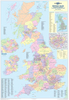
British Isles Wall Map (Tubed)
Fully updated for 2007-8, this wall chart features a brightly-coloured political map of Britain and Ireland with clear lettering and symbols for easy reference. Counties and administrative areas are picked out in distinctive colours to aid identification, with town and city names clearly shown. The main map scale is 1:1 600 000.Also includes a physical map of Britain and Ireland (showing rivers, hills and mountains), together with smaller thematic maps covering the important topics of population, wealth, climate and transport.Philip's Britain and Ireland Wall Map is supplied laminated on one side and rolled into a clear plastic tube. It is ideal for mounting on a classroom wall or for use at home. The clarity of the map detail ensures that it is highly accessible for children,
teachers and parents alike.Main map projection: Conical with two standard parallels.
teachers and parents alike.Main map projection: Conical with two standard parallels.
Product Description
Reviews/Comments
Add New
Vouchers
No voucher codes found.
Do you know a voucher code for this product or supplier? Add it to Insights for others to use.
Do you know a voucher code for this product or supplier? Add it to Insights for others to use.
 Denmark