
 United Kingdom
 France
 Germany
 Netherlands
 Sweden
 USA
USA
 Italy
Italy
 Spain
Spain
More From Contributor

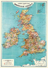


British Isles Physical Panoramic Wall Map
Decorative 108x150cm wall map presenting an elevated view of the British Isles from a position over the English Channel, such that Iceland can be seen disappearing over the northern horizon. The Channel Islands are included in a separate inset.Although major roads, towns and airports are depicted, the main emphasis is the physical geography, with relief strongly implied by the use of colour and hill shading. Heights of significant peaks are stated and major rivers and lakes are distinguished. International borders are indicated.

Product Description
Reviews/Comments
Add New
Vouchers
No voucher codes found.
Do you know a voucher code for this product or supplier? Add it to Insights for others to use.
Do you know a voucher code for this product or supplier? Add it to Insights for others to use.
 Denmark