
 United Kingdom
 France
 Germany
 Netherlands
 Sweden
 USA
USA
 Italy
Italy
 Spain
Spain
More From Contributor


British Isles In 1707 Cushion
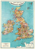
A colourful cushion with a map of the British Isles in 1707 from the British Library archives, part of a sophisticated and decorative collection from We Love Cushions designed to bring life and style to any room setting. England, Scotland, Wales and Ireland are shown in different colours against a background of the surrounding seas in light beige.The cover, printed using archival inks to get the brightest finish possible, with a super soft cotton linen mix, and comes complete with the cushion pad washable at 30º.To see other cushion designs in this series please lick on the series link.
Product Description
Reviews/Comments
Add New
Vouchers
No voucher codes found.
Do you know a voucher code for this product or supplier? Add it to Insights for others to use.
Do you know a voucher code for this product or supplier? Add it to Insights for others to use.
 Denmark