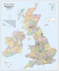
More From Contributor

£5.95
British Isles & Adjacent Areas: Earthquakes 1980-2008 wall map from the British Geological Survey showing the epicenters of earthquakes with symbols indicating their magnitude on the Richter scale: 1.5 -2.4 ML, 2.5
- 3.9 ML, & 4.0 ML & stronger. Coverage

Includes::
the English Channel & most of the North Sea. The base map has altitude colouring, & shows the network of main roads & locations of larges cities. Latitude & longitude lines are drawn at intervals of 5


...
Archived Product
£9.99
British Isles Communications Wall Map at 1:1, 000, 000 from the Ordnance Survey, size 93.5 x 104cm (3ft 1” x 3ft 5” approx), with a laminated surface which can be written on with suitable marker pens without damaging the map. The map shows the network of motorways, plus: A roads in Great Britain, A & B roads in Northern Irel&, & N & R roads in the Republic of Irel&. The map also shows railway lines, ferry routes with approx. times, airports (scheduled flights with or without customs & non-scheduled flights with customs) & heliports. The base map has colouring for national parks & area of scenic beauty. Map legend

Includes::
French & German.*LAMINATED & ENCAPSULATED WALL MAPS:*- *laminated* wall maps have a thin layer of plastic usually applied to the printed side only. They can be written on with suitable marker pens without any damage to the map but, unless laminated on both sides, they are not damp-proof.- *encapsulated* wall maps are sealed between two sheets of plastic. They are more rigid & heavier than laminated maps of the same size. They are damp-proof & do not crinkle in humid conditions. Encapsulation gives the map a shiny surface, similar to being displayed behind glass.- *please note:* many publishers & retailers often use these two terms interchangeably. Our map titles & descriptions follow the definitions provided above.

...
Archived Product
£5.99
Kalimedia have produced an original, fold out map of the British Isles that uncovers the true etymology behind familiar place names in the United Kingdom & the Republic of Irel&. Names are taken back to their roots & translated into English, giving us an unusual & intriguing insight into the character of peoples & places behind the more recognizable cartographic names. Many geographical names are clearly rooted in man’s observation of his natural environment. Physical geography has given rise to the Iles at the Edge of the Sea (Hebrides) & the Market by the Yawning Estuary (Ipswich). Unsurprisingly, places have often acquired names derived from the characteristics of the people who live there: The Great Land of the Tattooed (Great Britain) & Bear Guard’s Home (Birmingham). London is, possibly aptly, said to translate as ‘ Unaffordable River Town’! An A-Z listing of place names & their derivations, as featured on the map, is provided on the reverse of the sheet. ...
Archived Product
£12.99
British Isles Explorer map from Ocean Explorer Publications, designed to highlight interesting locations in United Kingdom & Ireland: historic towns, palaces, gardens, beautiful landscapes, etc. The map, ideal for planning a holiday, has on one side Great Britain with 72 locations highlighted & cross-referenced to brief descriptions. On the reverse, Scotland is also shown separately, this time highlighting 25 more sights of the country’s beauty spots & natural heritage. The reverse side also

Includes::
a map of Ireland with Northern Ireland where 31 locations are marked. All three maps use a satellite-based image showing names of major mountain rages & numerous towns; road network is not included. The maps also highlight various other places of interest not covered by the accompanying descriptions. Separate panels provide a list of monarchs from Edward the Confessor & Robert the Bruce to the present day, a brief timeline from 43AD to 1999, plus notes on the coastal wildlife & botany. Current edition of this title was published in July 2014.

...
Archived Product
£45.00
Cloth-backed small size version of A New Map of Irel&, originally published by William Faden around 1797 & dedicated to ” His Majesty King George the Third, The Patron & Promoter of every useful science”. Counties are in different colours, with the divisions into Ulster, Connaught, Leinster & Munster also marked. A pretty vignette of a rural scene with cupids decorates the title. This reproduction was taken from what used to be called a “cloth-dissected” map, made when the map itself was cut into sections & each section then individually pasted onto an overall cloth backing for the whole map. In this version the whole map is backed onto cloth in one piece but the gaps between the sections have been reproduced in the printing to preserve the style & the feeling of the original. Each individual map is presented folded in a colourful case covered with a unique design marbled paper – no two cases are identical.PLEASE NOTE: this title is also available in a larger size reproduction. To see the list of all the titles in this series from Old Folding Maps please click on the series link. ...
Archived Product
£25.99
Political wall map of the British Isles at 1:1, 000, 000 from Global Mapping, showing different counties in bold colouring. This is an ideal reference map, showing major cities, motorways & A roads. Ferry routes & airports are also indicated. There is also a distance table for numerous destinations, as well as separate insets showing the Channel & Shetland Islands. ...
Archived Product
£10.99
This beautifully illustrated folded map tells the story of the British Isles. The map shows key historical events & landmarks, from prehistoric times to the present day, presenting them in an exciting & original format. The map shows, for example, the Pilgrim Fathers leaving for America; the invention of vaccination; the founding of the first cricket club & the departure of the Titanic. The History Map will be appreciated by anyone who is interested in history or the British Isles, or who just loves maps. A particularly absorbing aspect of the History Map is its presentation of history in a geographical format, rather than the chronological one with which we are most familiar. The map has detailed text on the reverse side which gives descriptions of the events & landmarks shown on the front & indicates those which can be visited by the public. ...
Archived Product
£10.99
This beautifully illustrated wall map tells the story of the British Isles. The map shows key historical events & landmarks, from prehistoric times to the present day, presenting them in an exciting & original format. The map shows, for example, the Pilgrim Fathers leaving for America; the invention of vaccination; the founding of the first cricket club & the departure of the Titanic. The History Map will be appreciated by anyone who is interested in history or the British Isles, or who just loves maps. A particularly absorbing aspect of the History Map is its presentation of history in a geographical format, rather than the chronological one with which we are most familiar. The map has detailed text on the reverse side which gives descriptions of the events & landmarks shown on the front & indicates those which can be visited by the public. ...
Archived Product
£30.00
A colourful cushion with a map of the British Isles in 1707 from the British Library archives, part of a sophisticated & decorative collection from We Love Cushions designed to bring life & style to any room setting. Engl&, Scotl&, Wales & Ireland are shown in different colours against a background of the surrounding seas in light beige. The cover, printed using archival inks to get the brightest finish possible, with a super soft cotton linen mix, & comes complete with the cushion pad washable at 30º. To see other cushion designs in this series please lick on the series link. ...
Archived Product
£3.25
This is a beautiful & unique wrapping paper featuring a map of The British Isles from Cavallini & Co. measuring 51x 71 cm (20”x 28”). It is printed on thick quality Italian laid paper stock. Please note that this is not an up to date map. Perfect for wrapping special presents. Its high decorative qualities make it also ideal for framing & other creative purposes. ...
Archived Product

British Isles Geological SMALL

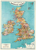
Cloth-backed small size version of A New Map of Ireland, originally published by William Faden around 1797 and dedicated to ”His Majesty King George the Third, The Patron and Promoter of every useful science”. Counties are in different colours, with the divisions into Ulster, Connaught, Leinster and Munster also marked. A pretty vignette of a rural scene with cupids decorates the title. This reproduction was taken from what used to be called a “cloth-dissected” map, made when the map itself was cut into sections and each section then individually pasted onto an overall cloth backing for the whole map. In this version the whole map is backed onto cloth in one piece but the gaps between the sections have been reproduced in the printing to preserve the style and the feeling of
the original. Each individual map is presented folded in a colourful case covered with a unique design marbled paper – no two cases are identical.PLEASE NOTE: this title is also available in a larger size reproduction. To see the list of all the titles in this series from Old Folding Maps please click on the series link.
RIP - This product is no longer available on our network. It was last seen on 25.09.2019

This page now acts as a permanent archive for this product. Add more information using the comments box below to ensure it can still be found by future generations.

Use our search facility to see if it is available from an alternative contributor.
  • Availability: Out Of Stock
  • Supplier: Stanfords
  • SKU: 9786000511326
Availability: In Stock
£20.00

Product Description

Cloth-backed small size version of A New Map of Irel&, originally published by William Faden around 1797 & dedicated to ” His Majesty King George the Third, The Patron & Promoter of every useful science”. Counties are in different colours, with the divisions into Ulster, Connaught, Leinster & Munster also marked. A pretty vignette of a rural scene with cupids decorates the title. This reproduction was taken from what used to be called a “cloth-dissected” map, made when the map itself was cut into sections & each section then individually pasted onto an overall cloth backing for the whole map. In this version the whole map is backed onto cloth in one piece but the gaps between the sections have been reproduced in the printing to preserve the style & the feeling of the original. Each individual map is presented folded in a colourful case covered with a unique design marbled paper – no two cases are identical.PLEASE NOTE: this title is also available in a larger size reproduction. To see the list of all the titles in this series from Old Folding Maps please click on the series link.

Reviews/Comments

Add New

Intelligent Comparison

Oooops!
We couldn't find anything!
Perhaps this product's unique.... Or perhaps we are still looking for comparisons!
Click to bump this page and we'll hurry up.

Price History

Vouchers

No voucher codes found.
Do you know a voucher code for this product or supplier? Add it to Insights for others to use.

Facebook

Jargon Buster

Paper - A thin sheet mainly used for writing. Available in a variety of colours. Made mainly from wood pulp.
King - The figure head of a monarch
Size - is the measurement of how big an object is in space.
Small - something that takes up less space than normal.
Preserve - To maintain something to its complete state
Design - A drawing or styles that shows the look and functionality of something before its made.
Individual - A single separate item or person.
Reproduction - A process of making a copy of something.

Supplier Information

Stanfords
Stanfords was established in 1853 and opened their iconic Covent Garden flagship store in 1901. They have become the top retailer of maps, travel books and accessories in the UK and arguably offer the largest selection of maps and travel books worldwide. Famous names such as Captain Robert Falcon Scott, Ranulph Fiennes and Michael Palin have purchased from Stanfords. They now have a shop in Bristol and both stores together with other venues operate a calendar of events including talks, book signings and exhibitions. As a specialist map retailer, the map selection is comprehensive and includes road maps, street maps and walking maps from worldwide destinations, as well as a selection of world atlases and wall maps. Books include travel guides and travel literature. Stanfords also stock globes, from miniatures made of blue marble to magnificent floor-standing globes. The website features a selection of interesting articles on travel topics.
Page Updated: 2023-11-12 20:15:36

Community Generated Product Tags

Oh No! The productWIKI community hasn't generated any tags for this product yet!
Menu