
 United Kingdom
 France
 Germany
 Netherlands
 Sweden
 USA
USA
 Italy
Italy
 Spain
Spain
More From Contributor


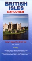
British Isles Explorer
British Isles Explorer map from Ocean Explorer Publications, designed to highlight interesting locations in United Kingdom and Ireland: historic towns, palaces, gardens, beautiful landscapes, etc. The map, ideal for planning a holiday, has on one side Great Britain with 72 locations highlighted and cross-referenced to brief descriptions. On the reverse, Scotland is also shown separately, this time highlighting 25 more sights of the country’s beauty spots and natural heritage. The reverse side also includes a map of Ireland with Northern Ireland where 31 locations are marked. All three maps use a satellite-based image showing names of major mountain rages and numerous towns; road network is not included. The maps also highlight various other places of interest not covered by the
accompanying descriptions. Separate panels provide a list of monarchs from Edward the Confessor and Robert the Bruce to the present day, a brief timeline from 43AD to 1999, plus notes on the coastal wildlife and botany. Current edition of this title was published in July 2014.
accompanying descriptions. Separate panels provide a list of monarchs from Edward the Confessor and Robert the Bruce to the present day, a brief timeline from 43AD to 1999, plus notes on the coastal wildlife and botany. Current edition of this title was published in July 2014.

Product Description
Reviews/Comments
Add New
Vouchers
No voucher codes found.
Do you know a voucher code for this product or supplier? Add it to Insights for others to use.
Do you know a voucher code for this product or supplier? Add it to Insights for others to use.
 Denmark