
 United Kingdom
 France
 Germany
 Netherlands
 Sweden
 USA
USA
 Italy
Italy
 Spain
Spain
More From Contributor


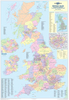
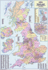
British Isles Wall Map Lemon - Orange - Thistle - Khaki ENCAPSULATED
Very decorative administrative wall map of the British Isles (100 x 70cm / 3’3” x 2’4” approx.) with a carefully graded palette of glossy shades of green shown against off-white sea background. Light relief shading with names of mountainous region and other geographical features provides topographic information and the map also shows the network of main roads. The map indicates boundaries of counties and unitary authorities, shown either with their names or with numbers cross-referenced to lists provided on the map.A separate enlargement covers the Greater London area, showing individual boroughs.
Product Description
Reviews/Comments
Add New
Vouchers
No voucher codes found.
Do you know a voucher code for this product or supplier? Add it to Insights for others to use.
Do you know a voucher code for this product or supplier? Add it to Insights for others to use.
 Denmark