
 United Kingdom
 France
 Germany
 Netherlands
 Sweden
 USA
USA
 Italy
Italy
 Spain
Spain
More From Contributor


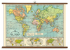


World Wall Map Junior Edition
Philip's World Wall Map (Junior Edition) is supplied laminated on one side and rolled into a sturdy cardboard tube. It is ideal for mounting on a classroom wall or for use at home. The clarity of the map detail ensures that it is highly accessible for children, teachers and parents alike. This brightly coloured wall map has been specially created for young children of primary and early secondary school age. It shows the whole of the World in political colours at a scale of 1:38M (1 cm on the map = 380 km on the ground), with clear large-size lettering and symbols. Individual countries are picked out in bright distinctive colours for easy identification, with major town and city names clearly shown, as well as major rivers. Larger-scale political maps are provided for the crowded
regions of Europe and the Caribbean (each at a scale of 1:20M), and there are additional maps of the Arctic and Antarctica (each at a scale of 1:50M) and a Pacific-centred map of the continents. Main map projection: Hammer Equal Area.
regions of Europe and the Caribbean (each at a scale of 1:20M), and there are additional maps of the Arctic and Antarctica (each at a scale of 1:50M) and a Pacific-centred map of the continents. Main map projection: Hammer Equal Area.
Product Description
Reviews/Comments
Add New
Vouchers
No voucher codes found.
Do you know a voucher code for this product or supplier? Add it to Insights for others to use.
Do you know a voucher code for this product or supplier? Add it to Insights for others to use.
 Denmark