
 United Kingdom
 France
 Germany
 Netherlands
 Sweden
 USA
USA
 Italy
Italy
 Spain
Spain
More From Contributor


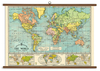

World Upside Down Pacific-Centred Hema Map
The world upside-down and Pacific-centred on a folded political map from Hema with bright colouring for countries and light blue oceans, offering the world as seen from Down Under - with Australia and New Zealand on top and in the centre. The choice of Mercator projection does, of course, greatly distort Greenland or the Arctic islands of Canada, Russia and Norway, but this only adds to the fun of seeing the world turned “the wrong way up”. All place names are in their English versions. No physical information is included beyond lakes and main rivers. Latitude and longitude lines are drawn at 20° intervals. Try viewing this map “the right way up” and then back to upside-down and see how one’s perception of what’s where changes!
Product Description
Reviews/Comments
Add New
Vouchers
No voucher codes found.
Do you know a voucher code for this product or supplier? Add it to Insights for others to use.
Do you know a voucher code for this product or supplier? Add it to Insights for others to use.
 Denmark