
 United Kingdom
 France
 Germany
 Netherlands
 Sweden
 USA
USA
 Italy
Italy
 Spain
Spain
More From Contributor


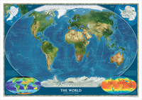
World Satellite Image NGS Wall Map PAPER
Global satellite mosaic of a cloud-free image of the Earth in its natural colours, as it would be seen from space. The map was produced for the NGS by NASA’s Jet Propulsion Laboratory using more than 500 satellite images prepared by the National Oceanic and Atmospheric Administration. One can easily identify the world’s major mountain ranges, glaciers, deserts, or rain forests. The colouring of the oceans shows various depths, with numerous trenches, ridges and fractures clearly visible.Polar Regions are included, shown as insets, whilst two smaller maps of the world provide information on the biosphere and surface temperature.* This title is also available encapsulated.

Product Description
Reviews/Comments
Add New
Vouchers
No voucher codes found.
Do you know a voucher code for this product or supplier? Add it to Insights for others to use.
Do you know a voucher code for this product or supplier? Add it to Insights for others to use.
 Denmark