
 United Kingdom
 France
 Germany
 Netherlands
 Sweden
 USA
USA
 Italy
Italy
 Spain
Spain
More From Contributor


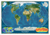
World Satellite Image NGS Wall Map ENCAPSULATED
Encapsulated version of a global satellite mosaic of a cloud-free image of the Earth in its natural colours, as it would be seen from space. The map was produced for the NGS by NASA’s Jet Propulsion Laboratory using more than 500 satellite images prepared by the National Oceanic and Atmospheric Administration. One can easily identify the world’s major mountain ranges, glaciers, deserts, or rain forests. The colouring of the oceans shows various depths, with numerous trenches, ridges and fractures clearly visible.Polar Regions are included, shown as insets, whilst two smaller maps of the world provide information on the biosphere and surface temperature.*LAMINATED and ENCAPSULATED WALL MAPS:*- *laminated* wall maps have a thin layer of plastic usually applied to the printed side
only. They can be written on with suitable marker pens without any damage to the map but, unless they have been laminated on both sides, they are not damp-proof.- *encapsulated* wall maps are sealed between two sheets of plastic. They are more rigid and heavier than laminated maps of the same size. They are damp-proof and do not crinkle in humid conditions. Encapsulation gives the map a shiny surface, similar to being displayed behind glass.- *please note:* many publishers and retailers often use these two terms interchangeably. Our map titles and descriptions follow the definitions provided above.
only. They can be written on with suitable marker pens without any damage to the map but, unless they have been laminated on both sides, they are not damp-proof.- *encapsulated* wall maps are sealed between two sheets of plastic. They are more rigid and heavier than laminated maps of the same size. They are damp-proof and do not crinkle in humid conditions. Encapsulation gives the map a shiny surface, similar to being displayed behind glass.- *please note:* many publishers and retailers often use these two terms interchangeably. Our map titles and descriptions follow the definitions provided above.
Product Description
Reviews/Comments
Add New
Vouchers
No voucher codes found.
Do you know a voucher code for this product or supplier? Add it to Insights for others to use.
Do you know a voucher code for this product or supplier? Add it to Insights for others to use.
 Denmark