
 United Kingdom
 France
 Germany
 Netherlands
 Sweden
 USA
USA
 Italy
Italy
 Spain
Spain
More From Contributor


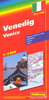
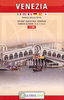

Venice
The National Geographic map of Venice at 1:6, 500 is a durable waterproof city map and transport guide designed for tourism. Clear and easy-to-read street mapping has main attractions highlighted and 3D illustrations of top sights. Hotels, churches, theatres and information points are among the tourist features marked on the map. One-way streets and pedestrian areas are indicated. The map covers from the mouth of the Grand Canal and Saint Lucia station in the east to Sant'Elena in the west, and from Cannaregio in the north to Guidecca in the south. An inset map shows Murano, and another inset on the reverse shows the Lido strip at 1:13, 000.The reverse of the map features background information, top sights and activities, basic essential tourist info and city transport network
details, including a detailed map of Vaporetto routes. There is also a small map of Marco Polo Airport showing terminals and transport connections. The map is indexed for streets, points of interest and hotels, and includes regional and national overview maps. This map is printed on a surprisingly strong rip-proof, waterproof paper.
details, including a detailed map of Vaporetto routes. There is also a small map of Marco Polo Airport showing terminals and transport connections. The map is indexed for streets, points of interest and hotels, and includes regional and national overview maps. This map is printed on a surprisingly strong rip-proof, waterproof paper.

Product Description
Reviews/Comments
Add New
Intelligent Comparison
Archived Product

Venice Stanfords
£7.95
Archived Product
Venice Stanfords
£7.95
Archived Product
Venice Stanfords
£3.99
Archived Product
Venice Stanfords
£4.99
Archived Product
Venice Stanfords
£6.50
Archived Product
Venice Stanfords
£14.95
Archived Product

Venice Stanfords
£11.99
Archived Product

Venice Stanfords
£4.99
Vouchers
No voucher codes found.
Do you know a voucher code for this product or supplier? Add it to Insights for others to use.
Do you know a voucher code for this product or supplier? Add it to Insights for others to use.
 Denmark