More From Contributor

£14.99
Trentino region of Italy on a set of three double-sided, GPS compatible & contoured maps at 1:50, 000 from Kompass, with hiking trails, cycling, ski & horse riding routes, various recreational facilities, etc. The set provides very wide coverage of this popular part of Italy, extending from north of Bolzano southwards to include the northern part of Lake Garda & west/east from Lake d ...
Archived Product
£9.50
Trentino
- Alto Adige at 1:200, 000 in Mair Dumont's Marco Polo regional series of Italy with special features to aid navigation
...
Archived Product
£9.99
Trentino
- Alto Adige at 1:200, 000 in Mair Dumont`s Marco Polo regional series of Italy with special features to aid navigation
...
Archived Product
£11.99
Trentino
- Alto Adige: South Tyrol
- Venice map at 1:200, 000 from Kümmerly & Frey with cartography from the Italian publishers

...
Archived Product
£9.50
Trentino
- Alto Adige region of Italy in Touring Club Italiano’s series of regional road maps at 1:200, 000, used by millions
...
Archived Product
£5.99

Includes: enlargements of Bolzano, Trento & Merano, all separately indexed. About this series: Indexed 1:200, 000 scale
...
Archived Product
£10.99
Trento at 1: 8, 000 with a detailed enlargement of the city’s historic centre at 1:4, 500, plus Rovereto at 1:6, 000 on indexed street plans from Litografia Artistica Cartografica in their Globalmap imprint. 36 monuments in Trento including historic buildings & churches, cultural or educational institutions, & important municipal buildings or facilities are numbered & listed next to the plan. Coverage of the Trento plan is extended further north by an inset at the same scale showing Gardolo. Litografia Artistica Cartografica (LAC) are Italy’s leading publishers of street plans with an extensive range of titles. Where appropriate, the plans include an enlargement showing the historic centre in greater detail. On each plan monuments including historic buildings & churches, archaeological sites, cultural or educational institutions, & important municipal buildings or facilities are numbered & listed next to the plan. Unless indicated to the contrary in the individual description, one way streets are not marked. Street index is on the reverse. ...
Archived Product
£7.95
Map No. 647, Trento & the Surrounding Area, from Kompass in a series providing detailed coverage of the Dolomites & Lake Garda area & supplementing their main series of walking maps of Italy at 1:50, 000. Maps in this series have a more detailed base & smaller contour interval than coverage at 1:50, 000. Cartography: maps at 1:25, 000 have contours at 25-m intervals. An overprint shows local & long-distance footpaths, including all the high level routes (Alte Vie). The maps also show the via ferrata paths along the iron rails & ladders fitted into the rock faces. Other information

Includes::
various types of accommodation (campsites, alpine huts & refuges, etc.), recreational facilities, places of interest, local bus stops, etc. Many titles also have mountain bike trails or ski routes. Selected titles include on the reverse panorama drawings of the area, as indicated in the individual descriptions. Geographical coordinates: most maps are now GPS compatible
- titles without geographical coordinates are annotated to that effect in their individual description. Map legend

Includes::
English.PLEASE NOTE BEFORE ORDERING! Booklets: many titles come with booklets describing the area and/or various hiking routes. These booklets are in Italian & German only, apart from a handful of titles where an English language booklet is specifically indicated in the individual description. So, unless English language booklet is actually mentioned, the map can only be supplied with an Italian/ German booklet. These booklets are not necessary to use the maps since, as stated above, full English language map legend is provided.


...
Archived Product
£12.99
Trento Province at 1:150, 000 in a series of handy size provincial road maps from Litografia Artistica Cartografica (LAC) with more minor local roads & country tracks than can be found on most regional maps from other publishers. This title is published with the traditional style LAC cartography.LAC’s provincial series is gradually being changed to a new style of digitally derived cartography, so presentation of adjoining titles may vary. All the maps have hill shading to represent the general relief with spot heights for selected peaks, & show a few more local roads & rough tracks than the other road map series. Intermediate road distances are indicated. Regional, provincial & communal borders are marked, & railways, funiculars, airports, sea ferry links & campsites are shown. The legend is in Italian only. The new, digitally produced editions are indexed & have enhanced, more finely drawn cartography: the hill-shading is less bold, motorway service areas are marked, natural parks are highlighted & an expanded range of symbols indicates various landmarks & sites, e.g. antiquities, churches, etc. Two styles of the new cartography are produced, differing only in the colour of the predominant background shading: grey or yellow/green. Some of the new editions include geographical coordinates for the map corners. The index of localities is on the reverse. To see all the titles in this series please click on the series link. ...
Archived Product
£16.99
Mountain areas of central & northern Sweden on waterproof & tear-resistant, GPS compatible topographic “ Fjällkartan” maps at 1:100, 000 & 1:50, 000 from Lantmäteriet
- the country’s national survey organization, with hiking & ski routes, campsites & youth hostels, etc. Relief is shown by contours at 20m intervals & enhanced by relief shading, plus colouring and/or graphics to indicate different types of vegetation or land use. An overprint shows trails for hiking & cross-country skiing, indicating waymarked or unmarked & summer or winter only routes. Also shown are mandatory & recommended trails for snowmobiles & areas prohibited for cross-country vehicles. Symbols indicate locations of campsites, youth hostels, huts & wind shelters, mountain lodges & other types of tourist accommodation, emergency telephones, etc. The maps have both a 1-km UTM grid & a latitude/longitude grid in steps of 10`. Map legend

Includes::
English. On the reverse there are descriptions of the area in Swedish only, GPS coordinates for selected locations, etc. Most sheets also include a brief note in English on public access regulations. To see the list of titles in this series please click on the series link.


...
Archived Product

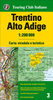
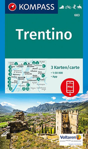
Trentino 3-Map Set Kompass 683

Trentino region of Italy on a set of three double-sided, GPS compatible and contoured maps at 1:50, 000 from Kompass, with hiking trails, cycling, ski and horse riding routes, various recreational facilities, etc. The set provides very wide coverage of this popular part of Italy, extending from north of Bolzano southwards to include the northern part of Lake Garda and west/east from Lake d’Idro to Feltre. The Alta Via routes, local sections of Sentiero Italia and other numerous long-distance trails are marked. KOMPASS HIKING MAPS OF ITALY: this title is part of an extensive series of walking maps from Kompass covering selected areas of Italy at mainly 1:50, 000, with a GPS compatible, contoured topographic base, extensive overprint for hiking routes, various types of
accommodation, numerous recreational facilities, places of interest, etc. TO SEE OTHER TITLES IN THIS SERIES PLEASE CLICK ON THE SERIES LINK.COVERAGE: the series covers the northern part of the Italian Alps, the lake region of Lombardy, the Dolomites, Italian Riviera, selected parts of Tuscany and Umbria, the Sorrento Peninsula, and the islands of the Tyrrhenian Sea. Coverage of the Dolomites by Kompass at more detailed scales (mainly 1:25, 000) is listed on our website in a separate series.CARTOGRAPHY: contour interval varies according to the terrain from 100m to 25m. All the maps highlight local hiking paths and, where appropriate, long-distance routes or via ferrata trails. Symbols indicate various types of accommodation such as selected inns and hotels, campsites, mountain
huts and refuges, etc. Most titles also show cycle or mountain bike trails and/or ski routes. Selected titles include on the reverse panorama drawings of the area, as indicated in the individual descriptions.GPS COMPATIBILITY: unless indicated to the contrary in the individual description, all the titles are GPS compatible, with latest editions providing a 2-km UTM grid.MAP LEGEND includes English.DURABILITY: new editions are now published on waterproof and tear-resistant synthetic paper, as indicated in the individual description.BOOKLETS: PLEASE NOTE BEFORE ORDERING! many titles come with a booklet describing the area and/or various hiking routes. Unless indicated in the individual description that the booklet includes English, these booklets are in Italian and German only. The
booklets are not necessary to use the maps since, as stated above, full English language map legend is provided.Kompass are Europe’s largest publishers of walking maps, with extensive coverage of hiking areas in other countries, all listed on our website.
RIP - This product is no longer available on our network. It was last seen on 25.09.2019

This page now acts as a permanent archive for this product. Add more information using the comments box below to ensure it can still be found by future generations.

Use our search facility to see if it is available from an alternative contributor.
  • Availability: Out Of Stock
  • Supplier: Stanfords
  • SKU: 9783990442654
Availability: In Stock
£16.50

Product Description

Trentino region of Italy on a set of three double-sided, GPS compatible & contoured maps at 1:50, 000 from Kompass, with hiking trails, cycling, ski & horse riding routes, various recreational facilities, etc. The set provides very wide coverage of this popular part of Italy, extending from north of Bolzano southwards to include the northern part of Lake Garda & west/east from Lake d’ Idro to Feltre. The Alta Via routes, local sections of Sentiero Italia & other numerous long-distance trails are marked. KOMPASS HIKING MAPS OF ITALY: this title is part of an extensive series of walking maps from Kompass covering selected areas of Italy at mainly 1:50, 000, with a GPS compatible, contoured topographic base, extensive overprint for hiking routes, various types of accommodation, numerous recreational facilities, places of interest, etc. TO SEE OTHER TITLES IN THIS SERIES PLEASE CLICK ON THE SERIES LINK.COVERAGE: the series covers the northern part of the Italian Alps, the lake region of Lombardy, the Dolomites, Italian Riviera, selected parts of Tuscany & Umbria, the Sorrento Peninsula, & the islands of the Tyrrhenian Sea. Coverage of the Dolomites by Kompass at more detailed scales (mainly 1:25, 000) is listed on our website in a separate series.CARTOGRAPHY: contour interval varies according to the terrain from 100m to 25m. All the maps highlight local hiking paths &, where appropriate, long-distance routes or via ferrata trails. Symbols indicate various types of accommodation such as selected inns & hotels, campsites, mountain huts & refuges, etc. Most titles also show cycle or mountain bike trails and/or ski routes. Selected titles include on the reverse panorama drawings of the area, as indicated in the individual descriptions.GPS COMPATIBILITY: unless indicated to the contrary in the individual description, all the titles are GPS compatible, with latest editions providing a 2-km UTM grid.MAP LEGEND

Includes::
English.DURABILITY: new editions are now published on waterproof & tear-resistant synthetic paper, as indicated in the individual description.BOOKLETS: PLEASE NOTE BEFORE ORDERING! many titles come with a booklet describing the area and/or various hiking routes. Unless indicated in the individual description that the booklet

Includes::
English, these booklets are in Italian & German only. The booklets are not necessary to use the maps since, as stated above, full English language map legend is provided. Kompass are Europe’s largest publishers of walking maps, with extensive coverage of hiking areas in other countries, all listed on our website.

Reviews/Comments

Add New

Intelligent Comparison

Oooops!
We couldn't find anything!
Perhaps this product's unique.... Or perhaps we are still looking for comparisons!
Click to bump this page and we'll hurry up.

Price History

Vouchers

No voucher codes found.
Do you know a voucher code for this product or supplier? Add it to Insights for others to use.

Facebook

Jargon Buster

GPS - Global Positioning System - Global position using satellites
Paper - A thin sheet mainly used for writing. Available in a variety of colours. Made mainly from wood pulp.
Hiking - An outdoor activity envolving walking in nature
Italian - A word used ot descibe something from Italy
Waterproof - Resistant to water, usualy specified by depth in metres
Set - a group of items usually related to one another. Some objects cannot function without the complete set of items.
Italy - a country in Europe.
Language - the method of communication used in different areas. Humans and computers have many different languages.
Km - Kilometre. A unit of measurement equal to 1000 metres.
Resistant - Something that can repel against something.
Horse - A large animal with four legs that tends to be ridden.
Wide - Something with a large width.
Accommodation - A room in which someone can live in, for example in a hotel
Popular - Something that is admired and liked by many people.
Individual - A single separate item or person.
Language - The way humans communicate either written and spoken.

Supplier Information

Stanfords
Stanfords was established in 1853 and opened their iconic Covent Garden flagship store in 1901. They have become the top retailer of maps, travel books and accessories in the UK and arguably offer the largest selection of maps and travel books worldwide. Famous names such as Captain Robert Falcon Scott, Ranulph Fiennes and Michael Palin have purchased from Stanfords. They now have a shop in Bristol and both stores together with other venues operate a calendar of events including talks, book signings and exhibitions. As a specialist map retailer, the map selection is comprehensive and includes road maps, street maps and walking maps from worldwide destinations, as well as a selection of world atlases and wall maps. Books include travel guides and travel literature. Stanfords also stock globes, from miniatures made of blue marble to magnificent floor-standing globes. The website features a selection of interesting articles on travel topics.
Page Updated: 2023-11-12 20:15:36

Community Generated Product Tags

Oh No! The productWIKI community hasn't generated any tags for this product yet!
Menu