
 United Kingdom
 France
 Germany
 Netherlands
 Sweden
 USA
USA
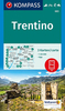
 Italy
Italy
 Spain
Spain
More From Contributor


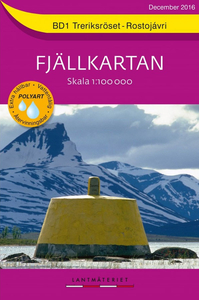
Treriksröset - Rostojavri Lantmateriet BD1
Mountain areas of central and northern Sweden on waterproof and tear-resistant, GPS compatible topographic “Fjällkartan” maps at 1:100, 000 and 1:50, 000 from Lantmäteriet - the country’s national survey organization, with hiking and ski routes, campsites and youth hostels, etc. Relief is shown by contours at 20m intervals and enhanced by relief shading, plus colouring and/or graphics to indicate different types of vegetation or land use. An overprint shows trails for hiking and cross-country skiing, indicating waymarked or unmarked and summer or winter only routes. Also shown are mandatory and recommended trails for snowmobiles and areas prohibited for cross-country vehicles. Symbols indicate locations of campsites, youth hostels, huts and wind shelters, mountain lodges
and other types of tourist accommodation, emergency telephones, etc. The maps have both a 1-km UTM grid and a latitude/longitude grid in steps of 10`. Map legend includes English. On the reverse there are descriptions of the area in Swedish only, GPS coordinates for selected locations, etc. Most sheets also include a brief note in English on public access regulations.To see the list of titles in this series please click on the series link.
and other types of tourist accommodation, emergency telephones, etc. The maps have both a 1-km UTM grid and a latitude/longitude grid in steps of 10`. Map legend includes English. On the reverse there are descriptions of the area in Swedish only, GPS coordinates for selected locations, etc. Most sheets also include a brief note in English on public access regulations.To see the list of titles in this series please click on the series link.

Product Description
Reviews/Comments
Add New
Vouchers
No voucher codes found.
Do you know a voucher code for this product or supplier? Add it to Insights for others to use.
Do you know a voucher code for this product or supplier? Add it to Insights for others to use.
 Denmark