More From Contributor

£7.99
The story of the great battles of the First World War has been told by historians, journalists & others. The shock & slaughter of the Somme, Verdun & Passchendaele are a major theme of most books. Large scale battles, however, comprised the smaller part of soldiers` total time in combat. For 90% of that time soldiers fought small scale battles. These small conflicts were violent, continual & involved complex weaponry & specialised tactics. Yet, during small battles, soldiers could & often did, make choices not possible during large ones. From these choices, there evolved between enemies a curious culture of live & let live which constrained the war culture of kill or be killed in fundamental ways. ...
Archived Product
£14.99
Think of a traditional Father Christmas; take away the beard so that you can see a beaming smile & a pair of glasses; remove the hat to reveal a slightly balding head; & replace the tunic to display a cardigan, always buttoned. Now you have a picture of how my grandfather, George Pine, appeared to me as a child. George was not a well-educated man, few of his generation were, but he had the most incredible memory & could tell a wonderful, gripping story. He could remember 50 or 60 years ago as if it were yesterday. Later on in life George lived at a residential home in Southmead, Bristol. The whole Pine family used to visit him as often as we could, including me & my wife Fran. He would then suspend his self-appointed role of organising all the residents (a legacy of his Sergeant Major training) & after a little prompting, sit down to retell some of his stories, still wearing a cardigan with buttons up the front. We thought that these stories were so interesting that in early 1972 we asked him to write them down. What follows are the memories that George recorded. The account you can now read probably contains less than half of the details that George could remember. Fran & I were hoping to read his account & visit him to record any missing details, but he wanted to finish the whole story before we read it. Unfortunately, he never did quite finish. George might not have had academic qualifications but he had qualities of which I am tremendously proud & which he passed on to his children. These qualities were resourcefulness, a fierce determination to always do your best, perseverance despite the difficulties & a deep loyalty to, & love of, family. I am very grateful to my brother-in-law, who has demonstrated these same qualities in expanding on over 40, 000 words of George`s handwritten memories. Clive has worked tirelessly, following up every conceivable lead, filling in many gaps & expanding upon George`s recollections. He has trawled through thousands of photographs & documents, delved in numerous public & private archives in the UK & abroad & visited France & Belgium, with friends & family, to follow George`s story. I recall one such visit to France. On one page in George`s handwritten account he drew a map of the German & British front lines. We were astonished to find that the map was uncannily accurate with the buildings & general terrain still there some 90 years later. I am sure this was just one of the discoveries that led Clive to spend so much time in researching & producing Trenches to Trams. He has transformed George`s handwritten pages from a family history to something much broader; touching on the First World War, Bristol Tramways & Carriage Company, Bristol in the Second World War & a slice of Bristol Social history from the 19th & 20th Centuries. The heart of George`s story is that of an ordinary Bristol Tommy who showed great courage, bravery & pluck in extraordinary times. Being the modest man he was, he would wish the readers of Trenches to Trams to consider it as a tribute to his generation & to a remarkable group of people
- his comrades & colleagues
- whose stories of heroism & sacrifice may never be told. John Pine

...
Archived Product
£4.95
Trent & Mersey Canal 1
- Preston Brook to Fradley Junction by GEOproject shows details of navigation & facilities available to
...
Archived Product
£3.50
Trent Vale & Hanford in 1898 in a fascinating series of reproductions of old Ordnance Survey plans in the Alan Godfrey Editions, ideal for anyone interested in the history of their neighbourhood or family. The map shows the area south of Stoke on Trent that

Includes::
Hanford village. Trent Vale is in the top left corner, Great Fenton Collieries & Iron Works in the top right corner. Other features include Sideway, St Matthias church, Hanford Bridge, Newcastle under Lyme Canal, brick works, stretch of North Staffordshire Railway with sidings to iron works, Chitlings Brook, River Trent, etc. On the reverse is a directory of Hanford. About the Alan Godfrey Editions of the 25” OS Series: Selected towns in Great Britain & Ireland are covered by maps showing the extent of urban development in the last decades of the 19th & early 20th century. The plans have been taken from the Ordnance Survey mapping & reprinted at about 15 inches to one mile (1:4, 340). On the reverse most maps have historical notes & many also include extracts from contemporary directories. Most maps cover about one mile (1.6kms) north/south, one & a half miles (2.4kms) across; adjoining sheets can be combined to provide wider coverage.FOR MORE INFORMATION & A COMPLETE LIST OF ALL AVAILABLE TITLES PLEASE CLICK ON THE SERIES LINK.

...
Archived Product
£3.50
Trentham in 1924 in a fascinating series of reproductions of old Ordnance Survey plans in the Alan Godfrey Editions, ideal for anyone interested in the history of their neighbourhood or family. The map covers the village of Trentham at the southern end of the Potteries. By 1924 Trentham Hall had been demolished but the map

Includes::
much of interest, showing the Trentham Gardens & Pleasure Grounds, village & Hemheath. Features include St Mary & All Saints church, Trentham Gardens, railway including Trentham Junction station, Trentham Park Branch with Trentham Park station, New Inn Mills, Trentham Hotel, Trent & Mersey Canal, Turbine Farm, New Inn Lane, etc. On the reverse is a 1912 directory of Trentham. * About the Alan Godfrey Editions of the 25” OS Series: Selected towns in Great Britain & Ireland are covered by maps showing the extent of urban development in the last decades of the 19th & early 20th century. The plans have been taken from the Ordnance Survey mapping & reprinted at about 15 inches to one mile (1:4, 340). On the reverse most maps have historical notes & many also include extracts from contemporary directories. Most maps cover about one mile (1.6kms) north/south, one & a half miles (2.4kms) across; adjoining sheets can be combined to provide wider coverage.FOR MORE INFORMATION & A COMPLETE LIST OF ALL AVAILABLE TITLES PLEASE CLICK ON THE SERIES LINK.

...
Archived Product
£9.50
Trentino
- Alto Adige at 1:200, 000 in Mair Dumont's Marco Polo regional series of Italy with special features to aid navigation
...
Archived Product
£9.99
Trentino
- Alto Adige at 1:200, 000 in Mair Dumont`s Marco Polo regional series of Italy with special features to aid navigation
...
Archived Product
£11.99
Trentino
- Alto Adige: South Tyrol
- Venice map at 1:200, 000 from Kümmerly & Frey with cartography from the Italian publishers

...
Archived Product
£9.50
Trentino
- Alto Adige region of Italy in Touring Club Italiano’s series of regional road maps at 1:200, 000, used by millions
...
Archived Product
£16.50
Trentino region of Italy on a set of three double-sided, GPS compatible & contoured maps at 1:50, 000 from Kompass, with hiking trails, cycling, ski & horse riding routes, various recreational facilities, etc. The set provides very wide coverage of this popular part of Italy, extending from north of Bolzano southwards to include the northern part of Lake Garda & west/east from Lake d’ Idro to Feltre. The Alta Via routes, local sections of Sentiero Italia & other numerous long-distance trails are marked. KOMPASS HIKING MAPS OF ITALY: this title is part of an extensive series of walking maps from Kompass covering selected areas of Italy at mainly 1:50, 000, with a GPS compatible, contoured topographic base, extensive overprint for hiking routes, various types of accommodation, numerous recreational facilities, places of interest, etc. TO SEE OTHER TITLES IN THIS SERIES PLEASE CLICK ON THE SERIES LINK.COVERAGE: the series covers the northern part of the Italian Alps, the lake region of Lombardy, the Dolomites, Italian Riviera, selected parts of Tuscany & Umbria, the Sorrento Peninsula, & the islands of the Tyrrhenian Sea. Coverage of the Dolomites by Kompass at more detailed scales (mainly 1:25, 000) is listed on our website in a separate series.CARTOGRAPHY: contour interval varies according to the terrain from 100m to 25m. All the maps highlight local hiking paths &, where appropriate, long-distance routes or via ferrata trails. Symbols indicate various types of accommodation such as selected inns & hotels, campsites, mountain huts & refuges, etc. Most titles also show cycle or mountain bike trails and/or ski routes. Selected titles include on the reverse panorama drawings of the area, as indicated in the individual descriptions.GPS COMPATIBILITY: unless indicated to the contrary in the individual description, all the titles are GPS compatible, with latest editions providing a 2-km UTM grid.MAP LEGEND

Includes::
English.DURABILITY: new editions are now published on waterproof & tear-resistant synthetic paper, as indicated in the individual description.BOOKLETS: PLEASE NOTE BEFORE ORDERING! many titles come with a booklet describing the area and/or various hiking routes. Unless indicated in the individual description that the booklet

Includes::
English, these booklets are in Italian & German only. The booklets are not necessary to use the maps since, as stated above, full English language map legend is provided. Kompass are Europe’s largest publishers of walking maps, with extensive coverage of hiking areas in other countries, all listed on our website.


...
Archived Product

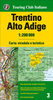
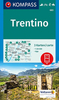
Trentino (3-map Set)

Trentino region of Italy on a set of three double-sided, GPS compatible and contoured maps at 1:50, 000 from Kompass, with hiking trails, cycling, ski and horse riding routes, various recreational facilities, etc. The set provides very wide coverage of this popular part of Italy, extending from north of Bolzano southwards to include the northern part of Lake Garda and west/east from Lake d
RIP - This product is no longer available on our network. It was last seen on 25.09.2019

This page now acts as a permanent archive for this product. Add more information using the comments box below to ensure it can still be found by future generations.

Use our search facility to see if it is available from an alternative contributor.
  • Availability: Out Of Stock
  • Supplier: Stanfords
  • SKU: 9783850269872
Availability: In Stock
£14.99

Product Description

Trentino region of Italy on a set of three double-sided, GPS compatible & contoured maps at 1:50, 000 from Kompass, with hiking trails, cycling, ski & horse riding routes, various recreational facilities, etc. The set provides very wide coverage of this popular part of Italy, extending from north of Bolzano southwards to include the northern part of Lake Garda & west/east from Lake d

Reviews/Comments

Add New

Intelligent Comparison

Oooops!
We couldn't find anything!
Perhaps this product's unique.... Or perhaps we are still looking for comparisons!
Click to bump this page and we'll hurry up.

Price History

Vouchers

No voucher codes found.
Do you know a voucher code for this product or supplier? Add it to Insights for others to use.

Facebook

Jargon Buster

GPS - Global Positioning System - Global position using satellites
Hiking - An outdoor activity envolving walking in nature
Set - a group of items usually related to one another. Some objects cannot function without the complete set of items.
Italy - a country in Europe.
Horse - A large animal with four legs that tends to be ridden.
Wide - Something with a large width.
Popular - Something that is admired and liked by many people.

Supplier Information

Stanfords
Stanfords was established in 1853 and opened their iconic Covent Garden flagship store in 1901. They have become the top retailer of maps, travel books and accessories in the UK and arguably offer the largest selection of maps and travel books worldwide. Famous names such as Captain Robert Falcon Scott, Ranulph Fiennes and Michael Palin have purchased from Stanfords. They now have a shop in Bristol and both stores together with other venues operate a calendar of events including talks, book signings and exhibitions. As a specialist map retailer, the map selection is comprehensive and includes road maps, street maps and walking maps from worldwide destinations, as well as a selection of world atlases and wall maps. Books include travel guides and travel literature. Stanfords also stock globes, from miniatures made of blue marble to magnificent floor-standing globes. The website features a selection of interesting articles on travel topics.
Page Updated: 2023-11-12 20:15:36

Community Generated Product Tags

Oh No! The productWIKI community hasn't generated any tags for this product yet!
Menu