
 United Kingdom
 France
 Germany
 Netherlands
 Sweden
 USA
USA
 Italy
Italy
 Spain
Spain
More From Contributor


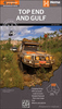


Top End And Gulf, NT/QLD
Top End and Gulf region on a waterproof and tear-resistant map from Hema covering at 1:1, 650, 000 approximately the top half of Northern Territory, with the adjoining region of Western Australia and the Gulf Country of Queensland. On the reverse several areas are presented on enlargements, including the Darwin region with the Kakadu National Park. The main map extends south along the Stuart Highway past Tennant Creek, west to Hall Creek in Western Australia, and eastwards into Queensland to include the Gulf Country from Mount Isa in the south to Pormpuraaw on the coast of Cape York. Topography is shown by relief shading, with colours and graphics indicating various types of terrain and highlighting national parks, protected areas, aboriginal lands, etc. A special feature of Hema
Product Description
Reviews/Comments
Add New
Vouchers
No voucher codes found.
Do you know a voucher code for this product or supplier? Add it to Insights for others to use.
Do you know a voucher code for this product or supplier? Add it to Insights for others to use.
 Denmark