
 United Kingdom
 France
 Germany
 Netherlands
 Sweden
 USA
USA
 Italy
Italy
 Spain
Spain
More From Contributor


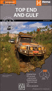
Top End And Gulf Hema
Top End and Gulf region on a waterproof and tear-resistant map from Hema covering at 1:1, 650, 000 approximately the top half of Northern Territory, with the adjoining regions of Western Australia and the Gulf Country of Queensland. On the reverse several areas are presented on enlargements, including the Darwin region with the Kakadu National Park. The main map extends south along the Stuart Highway past Tennant Creek, west to Halls Creek in Western Australia, and eastwards into Queensland to include the Gulf Country from Mount Isa in the south to Pormpuraaw on the western coast of Cape York. Topography is shown by relief shading, with colours and graphics indicating various types of terrain and highlighting national parks, protected areas, aboriginal lands, etc. A special feature
of Hema’s mapping of remote parts of Australia is the presentation of roads and tracks, distinguishing between those plotted by the publishers themselves with GPS and others taken from the country’s topographic survey data. Many road junctions are annotated with GPS waypoints. A wide range of symbols highlight various facilities including accommodation, campsites, different types of fuel supplies, general stores and meals, medical facilities, etc. Many locations are shown with phone numbers for more information. Latitude and longitude lines are drawn at 30’ intervals. The index is next to the map and lists locations with their GPS coordinates.On the reverse five areas are presented in greater detail on enlargements: the Darwin Region with the Kakadu National Park, Judbarra /
Gregory NP, Keep River NP, Boodjamulla (Lawn Hill) NP, and Nhulunbuy. A table shows what facilities can be found in the region’s national parks, and the map also provides extensive notes about the area and a list of useful contact addresses.To see the list of other regional map of Australia from Hema please click on the series link.

Product Description
Reviews/Comments
Add New
Vouchers
No voucher codes found.
Do you know a voucher code for this product or supplier? Add it to Insights for others to use.
Do you know a voucher code for this product or supplier? Add it to Insights for others to use.
 Denmark