
 United Kingdom
 France
 Germany
 Netherlands
 Sweden
 USA
USA
 Italy
Italy
 Spain
Spain
More From Contributor


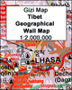


Tibet ITMB
Tibet at 1:1, 680, 000 on an indexed, double-sided map from ITMB printed on light, waterproof and tear-resistant synthetic paper, with a map of the Lhasa Valley and enlargements of the Potala – Barkor area and the Norbulingka.The map is double-sided, dividing the region east/west, with a small overlap and Lhasa included on both sides. Coverage includes most of Nepal and the map indicates the disputed areas along the border with India. All place names are shown only transliterated, with a few locations given alternative Tibetan names. Topography is indicated by altitude colouring (bands in feet), with plenty of names of topographic features: mountain ranges, peaks and mountain passes (heights in metres), etc. Additional graphics show glaciers, salt pans, swamps and deserts,
and national parks or protected areas are marked.The map shows the region’s road network, including selected tracks, indicates locations of border crossings and gives distances on main routes. Railway lines are included and local airports are marked. Symbols show locations of various places of interest, including monasteries. The map has latitude and longitude lines at 1° intervals and each side has a separate index.Insets provide a map of the Lhasa Valley at 1:80, 000 with a further enlargement for the Potala – Barkor area, both annotated with various facilities and places of interest. Another panel shows a more detailed plan of the Norbulingka Palace and Park.
and national parks or protected areas are marked.The map shows the region’s road network, including selected tracks, indicates locations of border crossings and gives distances on main routes. Railway lines are included and local airports are marked. Symbols show locations of various places of interest, including monasteries. The map has latitude and longitude lines at 1° intervals and each side has a separate index.Insets provide a map of the Lhasa Valley at 1:80, 000 with a further enlargement for the Potala – Barkor area, both annotated with various facilities and places of interest. Another panel shows a more detailed plan of the Norbulingka Palace and Park.

Product Description
Reviews/Comments
Add New
Vouchers
No voucher codes found.
Do you know a voucher code for this product or supplier? Add it to Insights for others to use.
Do you know a voucher code for this product or supplier? Add it to Insights for others to use.
 Denmark