More From Contributor

£14.99
The Python Years Diaries 1969-1979 by Michael Palin focuses on his years as part of Monty Python, revealing how it emerged & triumphed into a much-loved national television treasure that changed the face of British comedy. The years when Michael’s professional star was in its ascendancy were also years of development & growth in his personal life. The diaries tell of his growing family, his home in a north London terrace, which grows as he buys the house next door & then a second at the bottom of the garden! Not only are the diaries document to the extraordinary goings on behind the Python scene, with all of its powerful personalities, but they also reflect on his blossoming solo work as an actor, writer & producer. Highlights include his accounts of the making both The Holy Grail & the Life of Brian & the fight with American TV who wanted to bleep out all the best jokes. ...
Archived Product
£12.99
Portofino
- Golfo di Tigullio
- Golfo Paradiso, map no. 6, in a series of walking maps covering the Ligurian Alps & the coast,

...
Archived Product
£5.99
The Rough Guide Phrasebook Portuguese is the definitive phrasebook to help you make the most of your time in Portugal. Whether you want to book a hotel room, ask what time the train leaves or buy a drink from the bar, this new phrasebook will help you communicate with the locals in no time with a dictionary of over 5, 000 words. The free audio downloads, recorded by native Portuguese speakers, can be downloaded to your computer or MP3, allowing you to listen to the correct pronunciation of essential dialogues, ideal for practicing before you go or while you`re there. There`s even a regional pronunciation guide & Rough Guide travel tips, so wherever you are you can get around & speak the lingo. The Rough Guide Phrasebook Portuguese has an extensive two-way dictionary packed with vocabulary & a helpful menu & drinks list reader, perfect for choosing the right dish in any restaurant. With this phrasebook in your pocket you`ll never run out of things to say. ...
Archived Product
£25.00
South Pacific Anchorages by Warwick Clay details the harbours & anchorages in the pacific south of the equator between New Guinea & South America. The aim of the anchorage listing is to provide yachts with enough information so that they can choose their destination for the day, confident it will suit their needs & that they can arrive with the minimum of difficulty. Anchorages have been chosen to suit the long distance cruising yacht. They are all suitable for night anchoring of yachts drawing up to two meters & in most cases larger yachts. Sketches are provided for most of the better anchorages. ...
Archived Product
£7.99
The Mini Rough Guide to Paris is your perfect companion to Europe`s most visited & romantic capital. Discover Paris` highlights with stunning photography & detailed coverage, plus a full-colour section introducing Paris` hottest sights such as the Eiffel Tower & the stylish Marais quarter. Find detailed practical advice on what to see & do in Paris whilst relying on up-to-date descriptions of the best hotels & restaurants, the trendiest bars & the most old-fashioned cafes, & more offbeat attractions, such as new cutting-edge arts space, `the 104`. The Mini Rough Guide to Paris also helps you to plan day-trips from the city to Europe`s biggest attractions: Disneyland Paris & Versailles. Pocket-sized & portable, this edition comes complete with new colour maps, with grid references to help you explore every corner of this romantic city. ...
Archived Product
£7.99
The worst storm in history seem from the wheelhouse of a doomed fishing trawler; a mesmerisingly vivid account of a natural hell from a perspective that offers no escape. The `perfect storm` is a once-in-a-hundred-years combination: a high pressure system from the Great Lakes, running into storm winds over an Atlantic island
- Sable Island
- & colliding with a weather system from the Caribbean: Hurricane Grace. This is the story of that storm, told through the accounts of individual fishing boats caught up in the maelstrom, their families waiting anxiously for news of their return, the rescue services scrambled to save them. It is the story of the old battle between the fisherman & the sea, between man & Nature, but here Nature is an awesome & capricious power that transforms the surface of the Atlantic into an impossible tumult of water walls & gaping voids, with the capacity to break an oil tanker in two, let alone the 72ft swordfishing boat Andrea Gail with her crew of eight. A typical Hurricane encompasses a million cubic miles of atmosphere & can contain enough energy to, in theory, meet the electric power needs of the UK for a decade. Except that a hurricane will not be controlled. In spare, lyrical prose ` The Perfect Storm` describes what happened when the Andrea Gail looked into the wrathful face of the perfect storm.

...
Archived Product
£8.99
Pindos: Valia Kalda
- Vasilitsa area at 1:50, 000in a series of waterproof & tear-resistant hiking maps from Anavasi with a UTM
...
Archived Product
£39.99
Political map of the world from Global Mapping, extra large size 199 x 135cm (78.5” x 53” approx) – encapsulated version, with bright colouring of the individual countries pleasantly contrasted by the light blue oceans, relief shading for mountain ranges on land & the structure of the ocean floor, a panel of country flags, etc. The map is part of Global Mapping series of political maps presenting the world in four different sizes, as indicated below. This particular version has not yet been updated to show South Sudan or the new International Date Line &, unlike the three smaller versions, does not include a panel of flags.GLOBAL MAPPING POLITICAL MAPS OF THE WORLD:FORMAT &

Sizes:
the maps are available on paper or encapsulated & in four

Sizes:
199 x 135cm, 138 x 95cm, 99.5 x 69.5cm & 69.5 x 61cm on paper but slightly larger when encapsulated – please see individual entries for exact measurements. PRESENTATION: country names are in English. Within Europe, city names are as used in their countries (Köln, Wien, Warszawa); elsewhere the names vary (e.g. Viangchan for Vientiane). In USA, Canada, Brazil & Australia the map shows names of states/provinces, with their borders & administrative capitals. Relief shading shows elevation on land & particularly effectively on the ocean floor. On all four sizes clocks show time difference from GMT (but without indicating the exact geographical area covered by each time zone); the International Date Line is not included on the smallest version. Small, medium & large size versions include a panel of country flags under the map.PLEASE NOTE: as the scale & the size of the map increases, each version

Includes::
more cities & more geographical information (mountain ranges, islands, etc).*LAMINATED & ENCAPSULATED WALL MAPS:** Laminated* wall maps have a thin layer of plastic usually applied to the printed side only. They can be written on with suitable marker pens without any damage to the map but, unless laminated on both sides, they are not damp-proof.* Encapsulated* wall maps are sealed between two sheets of plastic. They are more rigid & heavier than laminated maps of the same size. They are damp-proof & do not crinkle in humid conditions. Encapsulation gives the map a shiny surface, similar to being displayed behind glass. Many publishers & retailers often use these two terms interchangeably. Our map titles & descriptions follow the definitions provided above.


...
Archived Product
£13.99
Peters equal area projection, with continents which at the first glance seemed in such unfamiliar distorted shapes, has by now become one of the standard presentations of the world. This political map, size 84 x 59cm (33” x 23” approx), using a projection invented by James Gall in the 19th century & popularised by Arno Peters in the 1970s, corrects the view of the world which most of us grow up with
- the Mercator or a similar projection which makes the Northern Hemisphere appear far larger than it really is. In this Peters Projection ENCAPSULATED version, each continent & within it each country is drawn to present them in correct relative size to the rest of the world. All place names are in their English versions. Latitude & longitude lines are drawn at 10º intervals. Under the map are drawings & text explaining how & why the Peter Projection is more accurate.PLEASE NOTE: this map is also available on paper without the encapsulation.WE REGRET THAT DUE ITS COPYRIGHT THIS ITEM CANNOT BE SOLD TO CUSTOMERS IN NORTH AMERICA.LAMINATED & ENCAPSULATED WALL MAPS:- LAMINATED wall maps have a thin layer of plastic usually applied to the printed side only. They can be written on with suitable marker pens without any damage to the map but, unless laminated on both sides, they are not damp-proof.- ENCAPSULATED wall maps are sealed between two sheets of plastic. They are more rigid & heavier than laminated maps of the same size. They are damp-proof & do not crinkle in humid conditions. Encapsulation gives the map a shiny surface, similar to being displayed behind glass.- PLEASE NOTE: many publishers & retailers often use these two terms interchangeably. Our map titles & descriptions follow the definitions provided above.
...
Archived Product
£8.99
Peters equal area projection, with continents which at the first glance seemed in such unfamiliar distorted shapes, has by now become one of the standard presentations of the world. This political map, size 84 x 59cm (33” x 23” approx), using a projection invented by James Gall in the 19th century & popularised by Arno Peters in the 1970s, corrects the view of the world which most of us grow up with
- the Mercator or a similar projection which makes the Northern Hemisphere appear far larger than it really is. In this Peters Projection version, each continent & within it each country is drawn to present them in correct relative size to the rest of the world. All place names are in their English versions. Latitude & longitude lines are drawn at 10º intervals. Under the map are drawings & text explaining how & why the Peter Projection is more accurate.PLEASE NOTE: this map is also available in an encapsulated format for better durability.WE REGRET THAT DUE ITS COPYRIGHT THIS ITEM CANNOT BE SOLD TO CUSTOMERS IN NORTH AMERICA.
...
Archived Product

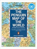
The Penguin Map Of The World

Political Map of the World from Penguin in a folded format at 1:35, 000, 000, including principal railway lines, main shipping routes with distances, a time chart with differences to GMT, and a panel of country flags, etc.The map shows countries in bright colours against pale blue oceans. Country names are in English but city names are in their original versions (Moskva, Beograd, Al Qahirah) with the English equivalent added in brackets in most but not all such cases. In Canada and Australia the map shows internal administrative divisions and names of provinces/states. On land main railway lines are marked and on the oceans major shipping routes are annotated with distances between the ports. There is no relief shading but major swamp areas are marked. More names of geographic
features such as mountain ranges, deserts, etc, are provided than is found on world maps of similar size, making this title look rather too “busy” in places. Latitude and longitude lines are drawn at intervals of 15°. Projection is Gall’s modified.Below the map is time line indicating difference to the Greenwich Mean Time, plus a colourful panel of country flags.
RIP - This product is no longer available on our network. It was last seen on 25.09.2019

This page now acts as a permanent archive for this product. Add more information using the comments box below to ensure it can still be found by future generations.

Use our search facility to see if it is available from an alternative contributor.
  • Availability: Out Of Stock
  • Supplier: Stanfords
  • SKU: 9780140515282
Availability: In Stock
£6.99

Product Description

Political Map of the World from Penguin in a folded format at 1:35, 000, 000, including principal railway lines, main shipping routes with distances, a time chart with differences to GMT, & a panel of country flags, etc. The map shows countries in bright colours against pale blue oceans. Country names are in English but city names are in their original versions (Moskva, Beograd, Al Qahirah) with the English equivalent added in brackets in most but not all such cases. In Canada & Australia the map shows internal administrative divisions & names of provinces/states. On land main railway lines are marked & on the oceans major shipping routes are annotated with distances between the ports. There is no relief shading but major swamp areas are marked. More names of geographic features such as mountain ranges, deserts, etc, are provided than is found on world maps of similar size, making this title look rather too “busy” in places. Latitude & longitude lines are drawn at intervals of 15°. Projection is Gall’s modified. Below the map is time line indicating difference to the Greenwich Mean Time, plus a colourful panel of country flags.

Reviews/Comments

Add New

Price History

Vouchers

No voucher codes found.
Do you know a voucher code for this product or supplier? Add it to Insights for others to use.

Facebook

Jargon Buster

Blue - A primary colour
World - A physical grouping, commonly used to describe earth and everything associated with ti
Size - is the measurement of how big an object is in space.
Greenwich - A southern borough in London.

Supplier Information

Stanfords
Stanfords was established in 1853 and opened their iconic Covent Garden flagship store in 1901. They have become the top retailer of maps, travel books and accessories in the UK and arguably offer the largest selection of maps and travel books worldwide. Famous names such as Captain Robert Falcon Scott, Ranulph Fiennes and Michael Palin have purchased from Stanfords. They now have a shop in Bristol and both stores together with other venues operate a calendar of events including talks, book signings and exhibitions. As a specialist map retailer, the map selection is comprehensive and includes road maps, street maps and walking maps from worldwide destinations, as well as a selection of world atlases and wall maps. Books include travel guides and travel literature. Stanfords also stock globes, from miniatures made of blue marble to magnificent floor-standing globes. The website features a selection of interesting articles on travel topics.
Page Updated: 2023-11-12 20:15:36

Community Generated Product Tags

Oh No! The productWIKI community hasn't generated any tags for this product yet!
Menu