More From Contributor
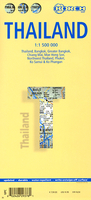
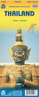
£13.99
Thailand
- Islands & Beaches in the Thematic Destinations series from Footprint; exploring a range of varied worldwide destinations,
...
Archived Product
£6.99
The countries of South-East Asia: Thail&, Vietnam, Cambodia, Laos, Myanmar/ Burma, Peninsular Malaysia & Singapore on a map at 1:2, 500, 000 from Marco Polo Publishing with an index which

Includes::
geographical features, three city maps, descriptions of 15 best sights, etc. Coverage extends west to Dhaka to include eastern Bangladesh & the north-eastern states of India. Cartography is from the renowned German publishers Mair Dumont. Relief shading with names of mountain ranges & spot heights, plus graphics for marshlands shows the topography. The map presents the regions` road & rail networks, also indicating local airports & ferry connections. Internal administrative boundaries are shown with names of the provinces & the map also indicates time zone boundaries. Interesting towns or villages & main cultural sights or natural curiosities are prominently highlighted, with 15 best sights cross-referenced to their descriptions in the booklet attached to the map cover. The map has latitude & longitude lines at intervals of 1°. Multilingual map legend & the descriptions include English. Extensive index is in a separate 47-page booklet attached to the map cover &

Includes::
major sights & topographic features such as rivers, lakes, volcanoes, glaciers, etc; also provided are lists of national parks & World Heritage sites across the whole are of the map. Street plans show central Bangkok, Phnom Penh & Singapore. A fold-out flap in the cover shows for route planning an overview of the whole area covered by the map prominently highlighting main places of interest, with the grid reference system in the margins making it easier to find locations on the main map. Also included are a distance/driving times table & basic driving regulations.


...
Archived Product
£9.99
Thailand at 1:1, 325, 000 in a series of Adventure maps from the National Geographic Society with cartography provided by Reise Know-How. The map is double-sided & printed on light waterproof & tear-resistant plastic paper. Cartographic information provided by Reise Know-How has been adjusted to follow the house style of the NGS Adventure series with greater emphasis on the country’s topography. Altitude colouring in broader bands has been replaced here by contours at 200m intervals. Boundaries of national parks & other protected areas are very prominently highlighted. Road network

Includes::
selected minor local roads & tracks. Distances are marked on main routes. Railway lines are included & local airports are marked. Internal administrative boundaries are shown with names of the provinces. Symbols indicate numerous places of interest, including UNESCO world heritage sites, temples, archaeological remains, beaches & diving sites, etc. The map has a latitude & longitude grid at intervals of 1° & an extensive index of localities which

Includes::
a separate list of national parks & other protected areas. Overall, the NGS map presents a more vivid picture of the country’s topography, whilst the original RK-H version provides clearer information for touring the country by road or rail.PLEASE NOTE: to ensure regular supplies & faster delivery to our customers we keep this title in regular stock in its Reise Know-How edition. The NGS versions can be ordered on request.


...
Archived Product
£12.95
This title offers a wonderful collection of fascinating facts, amazing anecdotes, & incredible stories celebrating the unique nature & diversity that is Thail&. Who invented the dish Phad Thai & why? What are the seven characteristics that allow an elephant to be deemed a ”white elephant”? What rights & privileges are prisoners accorded in jail? How much green space is there in Bangkok? What are the top-ten highest grossing Thai films of all-time? ” Thailand at Random” provides answers to these & many other fun & fascinating questions about the country. Complete with illustrations & graphics, this book explores the quirky & mysterious, busts myths, & offers surprising new information about everything Thai, including geography & infrastructure, customs & superstitions, & people & culture. Easy to read, pick up ” Thailand at Random” & gain quick insights into a wonderfully interesting country. ...
Archived Product
£14.99
Thailand Beaches & Islands Eyewitness travel guide from Dorling Kindersley is a lavishly illustrated book concerned with providing the visitor with detailed background information to sightseeing in the country & a broad cultural introduction. Popular historical buildings & museums are often described with cutaway diagrams allowing you to view ...
Archived Product
£12.99
Thailand in Marshall Cavendish's Culture Shock! Series; comprising a range of guides that inform visitors of the finer points & details relating to social etiquette, traditions & customs; bringing visitors to a sensitive yet substantial understanding of the country or city in question. The series targets those who are planning long stays in the destination or extended periods of residence. The guides are written by authors who have experienced the joys & pitfalls of cultural adaptation, & so are ideally placed to provide informative & relevant advice. Each title contains insights into local culture & traditions, guidance on adapting to the local environment, linguistic help & lots of general advice about local culture & idiosyncrasies to help prepare readers for their visit. Each title is structured similarly, beginning with the first impressions a visitor might expect to have. The guides aim to help readers understand the local culture through first appreciating the motivations, beliefs & attitudes of the local people. Practical advice on settling in is provided, with focused sections on accommodation, utilities, health, education & telecommunications. There is also extensive information on the destination ...
Archived Product
£12.99
Thailand in Marshall Cavendish`s Culture Shock! Series; comprising a range of guides that inform visitors of the finer points & details relating to social etiquette, traditions & customs; bringing visitors to a sensitive yet substantial understanding of the country or city in question. The series targets those who are planning long stays in the destination or extended periods of residence. The guides are written by authors who have experienced the joys & pitfalls of cultural adaptation, & so are ideally placed to provide informative & relevant advice. Each title contains insights into local culture & traditions, guidance on adapting to the local environment, linguistic help & lots of general advice about local culture & idiosyncrasies to help prepare readers for their visit. Each title is structured similarly, beginning with the first impressions a visitor might expect to have. The guides aim to help readers understand the local culture through first appreciating the motivations, beliefs & attitudes of the local people. Practical advice on settling in is provided, with focused sections on accommodation, utilities, health, education & telecommunications. There is also extensive information on the destination’s culture, food & leisure, in addition to a specific section addressing the concerns of those travelling on business. ...
Archived Product
£22.99
Thailand Deluxe Atlas from Thinknet, in a large spiral-bound format, with mapping of the whole country at 1:550, 000, plus plans or enlargements of over 100 towns & islands, all with extensive overprint highlighting sights, tourist accommodation, various facilities, etc. Thailand is covered on 38 pages of mapping at 1:550, 000 showing the country’s road & rail networks & highlighting various places of interest, including cultural & historical sites, national parks & other protected areas, waterfalls & dams or reservoirs, etc. Road network shows locations of petrol stations & border crossings from the neighbouring countries. Topography is indicated by altitude colouring. No geographical coordinates are marked. The index lists towns by province, with separate lists of tourist attractions & other places highlighted on the map.* Please note: the atlas has small, often difficult to see symbols to indicate locations of towns, with their names in tiny print, so that even well know places like Chiang Mai are not easy to find without some knowledge of Thailand’s geography or its division into administrative provinces.* The road maps also indicate which towns & islands are covered by more detailed mapping showing main traffic arteries, with very extensive overprint highlighting various institutions & public offices, hotels & restaurants, street markets & shopping centres, historical sites & places of worship, etc. Each map has an index of main facilities marked on it including, where appropriate, accommodation & tourist attractions. Also provided is a street plan of central Bangkok, a map of the capital’s expressways & the outer ring road, & a comprehensive distance table with a map of driving times & distances, plus a detailed plan of the Suvarnabhumi Airport. All the information is in Thai & English. * Please note: print size, of both names & symbols, is smaller than usually found on maps.* ...
Archived Product
£14.39
Thailand in the Discover series from Lonely Planet; covering a range of countries worldwide & practically designed to allow travellers to find the most iconic sites & attractions at a glance. Uniquely designed, each title in the series

Includes::
a series of lists of the best things to do & see, with highlights, thematic

...
Archived Product
£11.99
Thailand in the Diving & Snorkeling series from Lonely Planet; exploring the diving opportunities in a range of popular international diving sites. Frank & informal in style, the guides offer practical advice to travelers on specific diving holidays or those wanting to dive or snorkel while away. The guides offer practical advice on a large number of diving sites in the region & are suitable for advanced divers & novices alike. Widely recognized for their reliability, each Lonely Planet Diving & Snorkeling guide has the same layout. Extensive introductory chapters cover facts about the region, including history, geography & language, practical guidance on what to bring, the rating system for dives & divers, ...
Archived Product

Thailand Borch

Laminated and waterproof tourist map of Thailand from Borch, with street plans of Bangkok, Greater Bangkok, Chang Mai and Mae Hong Son, plus enlargements of Phuket, north-west Thailand, Ko Samui and Ko Phangan - all with indexes listing places of interest. The main map covers Thailand at 1:1, 500, 000, with the eastern part shown as an inset, shows the country’s road network and highlights numerous national parks and other protected areas, beaches and scuba diving sites, temples and archaeological sites, and various other places of interest. Topography is shown by relief shading with spot heights. Names of most towns and national parks are shown in both Thai and Latin alphabets, with smaller settlements in Latin alphabet only. On the reverse, street plans of Bangkok (1:22,
000), Greater Bangkok (1:125, 000), Ching Mai (1:22, 000) and Mae Hong Son (1:14, 000) show selected hotels, services, and various places of interest. Enlargements cover the north-western region of the country (1:835, 000), Phuket 1:350, 000), plus Ko Samui and Ko Phangan (1:350, 000). All the maps and street plans are indexed with lists of localities/streets and places of interest. Also included is information on the monthly average temperature, sunshine, precipitation, and humidity and a small administrative map of the country. Multilingual map legend includes English.
RIP - This product is no longer available on our network. It was last seen on 25.09.2019

This page now acts as a permanent archive for this product. Add more information using the comments box below to ensure it can still be found by future generations.

Use our search facility to see if it is available from an alternative contributor.
  • External links may include paid for promotion
  • Availability: Out Of Stock
  • Supplier: Stanfords
  • SKU: 9783866093768
Availability: In Stock
£9.99

Product Description

Laminated & waterproof tourist map of Thailand from Borch, with street plans of Bangkok, Greater Bangkok, Chang Mai & Mae Hong Son, plus enlargements of Phuket, north-west Thail&, Ko Samui & Ko Phangan
- all with indexes listing places of interest. The main map covers Thailand at 1:1, 500, 000, with the eastern part shown as an inset, shows the country’s road network & highlights numerous national parks & other protected areas, beaches & scuba diving sites, temples & archaeological sites, & various other places of interest. Topography is shown by relief shading with spot heights. Names of most towns & national parks are shown in both Thai & Latin alphabets, with smaller settlements in Latin alphabet only. On the reverse, street plans of Bangkok (1:22, 000), Greater Bangkok (1:125, 000), Ching Mai (1:22, 000) & Mae Hong Son (1:14, 000) show selected hotels, services, & various places of interest. Enlargements cover the north-western region of the country (1:835, 000), Phuket 1:350, 000), plus Ko Samui & Ko Phangan (1:350, 000). All the maps & street plans are indexed with lists of localities/streets & places of interest. Also included is information on the monthly average temperature, sunshine, precipitation, & humidity & a small administrative map of the country. Multilingual map legend

Includes::
English.

Reviews/Comments

Add New

Price History

Vouchers

No voucher codes found.
Do you know a voucher code for this product or supplier? Add it to Insights for others to use.

Facebook

Jargon Buster

Waterproof - Resistant to water, usualy specified by depth in metres
Network - A link and communication between things. Often computers or people.
Small - something that takes up less space than normal.
Road - a manmade lane or a path that is used to speed up travel.
Laminated - A thin layer of plastic that gives a coating and shine to a material.

Supplier Information

Stanfords
Stanfords was established in 1853 and opened their iconic Covent Garden flagship store in 1901. They have become the top retailer of maps, travel books and accessories in the UK and arguably offer the largest selection of maps and travel books worldwide. Famous names such as Captain Robert Falcon Scott, Ranulph Fiennes and Michael Palin have purchased from Stanfords. They now have a shop in Bristol and both stores together with other venues operate a calendar of events including talks, book signings and exhibitions. As a specialist map retailer, the map selection is comprehensive and includes road maps, street maps and walking maps from worldwide destinations, as well as a selection of world atlases and wall maps. Books include travel guides and travel literature. Stanfords also stock globes, from miniatures made of blue marble to magnificent floor-standing globes. The website features a selection of interesting articles on travel topics.
Page Updated: 2023-11-12 20:15:36

Community Generated Product Tags

Oh No! The productWIKI community hasn't generated any tags for this product yet!
Menu