
 United Kingdom
 France
 Germany
 Netherlands
 Sweden
 USA
USA
 Italy
Italy
 Spain
Spain
More From Contributor


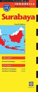
Surabaya Periplus Travel Map
Surabaya, Indonesia’s second largest city on Java, on a double-sided, indexed street plan at 1:20, 000 from Periplus, plus a road map of the city’s environs. The map divides the city north/south and extends out to include Ir. Juanda International Airport in the south-eastern corner. Main traffic arteries across the city are highlighted and locations of petrol stations are marked. Symbols indicate various places of interest and facilities, including numerous hotels, banks, restaurants, shopping centres, foreign consulates, places of worship, etc. Accompanying panel provides a road map of Surabaya’s environs at 1:125, 000.

Product Description
Reviews/Comments
Add New
Vouchers
No voucher codes found.
Do you know a voucher code for this product or supplier? Add it to Insights for others to use.
Do you know a voucher code for this product or supplier? Add it to Insights for others to use.
 Denmark