
 United Kingdom
 France
 Germany
 Netherlands
 Sweden
 USA
USA
 Italy
Italy
 Spain
Spain
More From Contributor


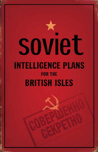
Soviet Intelligence Plans For The British Isles
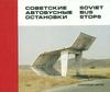
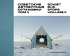
During the Cold War, the Soviet military embarked on a massive project to create maps of much of the world. As part of this exercise, many towns and cities in the British Isles were mapped in astonishing detail and to great accuracy, providing the Soviet Union with strategic intelligence on key British and Irish locations. These were not simply copies of existing local maps but included much original research. After the collapse of the Soviet Union, news of these previously secret maps started to emerge in the former Soviet Republics - now newly independent countries - where they had been stored ready for use. An archive of the maps was subsequently acquired by the Bodleian Library. Little is yet known about why the maps were made or how the information was gathered. In this
fascinating volume, John Davies and Alex Kent look at the street plans of over thirty British and Irish towns. The authors examine some of their anomalies and inaccuracies as well as highlighting the surprising wealth of information they contain, including road-widths, bridge-heights, river-depths, street names and every strategic installation of possible significance.Their expert commentary offers suggestions about the sources of the data and what the maps may reveal about the methods used to compile the information during a period of deep mutual suspicion between the Soviet Union and the West.
fascinating volume, John Davies and Alex Kent look at the street plans of over thirty British and Irish towns. The authors examine some of their anomalies and inaccuracies as well as highlighting the surprising wealth of information they contain, including road-widths, bridge-heights, river-depths, street names and every strategic installation of possible significance.Their expert commentary offers suggestions about the sources of the data and what the maps may reveal about the methods used to compile the information during a period of deep mutual suspicion between the Soviet Union and the West.

Product Description
Reviews/Comments
Add New
Vouchers
No voucher codes found.
Do you know a voucher code for this product or supplier? Add it to Insights for others to use.
Do you know a voucher code for this product or supplier? Add it to Insights for others to use.
 Denmark