More From Contributor
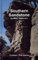
£9.99
Southern part of the Quebec Province from North Bay in Ontario to the eastern tip of the De Gaspé Peninsula, on a double-sided, indexed map at 1:850, 000 from ITMB, with an enlargement for the Montreal – Laval area, plus a street plan of Montreal’s downtown district. Coverage, with a small overlap between the sides, extends north to James Bay in the north-west & Ile-Rene-Levasseur on the eastern half of the map. The map shows the region’s road & rail networks, indicating toll highways & showing driving distances on selected main routes. Symbols mark various facilities & places of interest, with provincial parks prominently highlighted. The map has latitude & longitude lines at 1º intervals & is indexed. Inset panels show main traffic arteries across Montreal – Laval area, plus a detailed & informative street plan of Montral’s central districts highlighting selected hotels, important buildings, etc. ...
Archived Product
£9.99
The Southern Railway Map 1924: Waterloo to Padstow & Ilfracombe from The Old Book House presents the whole route divided into six separate panels: from Waterloo past Exeter’s St David’s station to Colebrooke Junction & then either northwards to Ilfracombe via Barnstaple, or westwards to Padstow. Unlike its companion maps presenting other famous railway routes, this title is printed on a 62 x 90cm sheet. All stations along the route are marked & annotated with distances from Waterloo. The map also shows tunnels & other railway lines connecting to or crossing the route, indicating sections closed since 1924. All along its course the route is annotated with comments on various features of the line & local sights, etc, including text describing changes since 1924. Further background notes are provided in a panel at the bottom of the map & in its elegant card cover. Please note: this title is also available as part of a four-map set with similar maps of the main routes from the GWR, LM&SR & L&NER companies. ...
Archived Product
£5.99
1948: with post-war Britain`s sense `dulled by traffic & by bombs`, this pocket-sized book was a clarion call for readers to rediscover the beauties of the idyllic English countryside. Published by Southern Railways, it recounts the joys of listening to birdsong, picking whortleberries, gazing at the clouds & `being genial` in the bars of tiny village inns
- experiences that had been obscured by war, deprivation & the bus & train journeys that suburbanisation had brought. Offering twenty real country walks around Surrey & Kent, this guide reveals where the 1940s rambler would be `most likely to find quietude & loveliness`
- as well as the best cakes!

...
Archived Product
£5.99
Southern Rockies: Arizona
- Colorado
- New Mexico
- Utah Zoom Map from Michelin at 1:1, 267, 200 (1” to 20 miles), with


...
Archived Product
£19.99
The southern part of Sweden in a series of 30 double-sided cycling maps from Norstedts printed on light, waterproof & tear-resistant synthetic paper. Mainland is covered at 1:90, 000 with Gotland at 1:100, 000. The maps, prepared in association with Cykelfrämjandet
- Sweden’s largest national cycling organization, highlight all the national & other major cycle routes, plus a selection of local routes. The overprint indicates sections which are on gravel roads and/or not singposted. Also marked are selected hiking trails. A range of symbols indicate various facilities & places of interest, including campsites & youth hostels, wind shelters, cultural & historical sites, interesting nature & geological spots, etc. The maps provide a very detailed picture of the road network, including privately maintained roads open to the general public. Railway lines are shown with stations & ferry connections are marked. Topography is indicated by light relief shading with spot heights, plus colouring and/or graphics for forests & marshl&. The maps have a UTM grid, plus latitude & longitude lines at intervals of 10’. Map legend

Includes::
English. Each map also provides phone numbers & web addresses of local tourist offices.


...
Archived Product
£34.95
The Southern Sandstone climbing area is situated in the Southeast of England on the borders of Kent & East Sussex. It offers some superb top-rope climbing & bouldering on beautiful sandstone formations. This will be the first Rockfax guidebook to cover the climbing & bouldering. The book will use the usual Rockfax style
- big full-colour photo-topos, detailed maps & full text descriptions
- all lavishly supported by some great action photography. Crags Covered Bowles Rocks, Eridge Rocks, Harrison`s Rocks, High Rocks, High Rocks Annexe, Happy Valley, Bull`s Hollow, Toad Rocks, Mount Edgecumbe Rocks, Bassett`s Farm Rocks, Under Rockes, Stone Farm

...
Archived Product
£5.99
Southern Scotland & Northumberland at 1:250, 000 in a series of three indexed road maps from Nicolson Maps using Ordnance Survey mapping, providing the best topographic information, with contours, altitude colouring, relief shading & plenty of names of geographical

Features:
glens, valleys, etc. The maps provide the best, & unique among the road map series, representation of the terrain. Contours are at approx. 61m intervals (200 feet), with spot height in metres. Altitude colouring is enhanced by relief shading, giving a vivid picture of the mountainous areas. Marshlands are shown, plus along the sea shore s&, dunes, foreshore & the high water mark. The maps indicate the boundaries of the national parks as well as long-distance paths & national trails. Road network highlights primary route destinations, & indicates services & rest areas on main routes, tolls, gradients, etc. Narrow roads with passing places are very clearly marked. Driving distances are given on main routes & selected B roads. Railway lines are shown with stations & ferry routes are marked. Tourist information provided by symbols

Includes::
campsites & caravan parks, youth hostels, viewpoints, historic & cultural heritage sites, sport & recreational facilities, etc. The maps grid lines are placed at intervals of 10km. The index is located in the reverse of the map & the map legend

Includes::
French & German.


...
Archived Product
£5.99
Southern Scotland with Northumberland at 1:250, 000 from the Ordnance Survey with excellent presentation of the landscape by altitude colouring with contours & hill shading, plus prominent highlighting of National & Forest Parks, ideal for planning interesting picturesque routes. Coverage starts at Durham & extends north across southern & central Scotland to Loch Tay in the Highlands. Maps in this OS series have bold altitude colouring enhanced by hill shading & contours at 200 feet (61 metres approx) intervals: spot heights are given in metres. Boundaries of National & Forest Parks are prominently marked & further colouring shows woodlands & sandy beaches. Road network, finely graded into 10 types, indicates dual carriageways & road width, primary route destinations, restricted junctions, services, tolls, narrow roads with passing places, steep gradients, level crossings, etc. Railways are shown with stations & ferry connections indicate crossing times. A range of symbols highlight various facilities & places of interest including campsites, youth hostels, information centres, historic sites & buildings, etc. The maps have the lines of the British National grid at 10km intervals, plus latitude & longitude margin ticks at 10’. The index lists main towns. To see the list of titles in this series please click on the series link. ...
Archived Product
£19.99
The southern part of Sweden in a series of 30 double-sided cycling maps from Norstedts printed on light, waterproof & tear-resistant synthetic paper. Mainland is covered at 1:90, 000 with Gotland at 1:100, 000. The maps, prepared in association with Cykelfrämjandet
- Sweden’s largest national cycling organization, highlight all the national & other major cycle routes, plus a selection of local routes. The overprint indicates sections which are on gravel roads and/or not singposted. Also marked are selected hiking trails. A range of symbols indicate various facilities & places of interest, including campsites & youth hostels, wind shelters, cultural & historical sites, interesting nature & geological spots, etc. The maps provide a very detailed picture of the road network, including privately maintained roads open to the general public. Railway lines are shown with stations & ferry connections are marked. Topography is indicated by light relief shading with spot heights, plus colouring and/or graphics for forests & marshl&. The maps have a UTM grid, plus latitude & longitude lines at intervals of 10’. Map legend

Includes::
English. Each map also provides phone numbers & web addresses of local tourist offices.


...
Archived Product
£16.99
Insight Guides: all you need to inspire every step of your journey. An in-depth book, now with free app & e Book. Spain`s largest region is also its most bewitching, from the fabulous Alhambra to the white towns of the sierras & vibrant Seville. This thoroughly revised edition

Includes::
Andalucía`s Costa del Sol, Seville, Ronda, Cordoba, Granada, Las Alpujarras & more· Over 256 pages of insider knowledge from local experts· In-depth on history & culture, from Andalucía`s rugged wilderness to the region`s claims to fame: flamenco & sherry· Enjoy special features on Andalusian food, festivals & exquisite gardens·

Includes::
innovative extras that are unique in the market
- all Insight Guides to countries & regions come with a free e Book & app that`s regularly updated with new hotel, bar, restaurant, shop & local event listings· Invaluable maps, travel tips & practical information ensure effortless planning · Inspirational colour photography throughout· Inventive design makes for an engaging reading experience


...
Archived Product

Southern Sandstone

Southern Sandstonecovers the big three outcrops in the area, Bowles, Harrison`s and Stone Farm plus many other less popular and therefore less worn craggs. Includes informative colour photographs, diagrams showing the climbing routes and also the layout of the rocks. Also includes location maps, to help drivers of cyclists get to the crags. There is also some information on chalk and sea cliff climbing.
RIP - This product is no longer available on our network. It was last seen on 25.09.2019

This page now acts as a permanent archive for this product. Add more information using the comments box below to ensure it can still be found by future generations.

Use our search facility to see if it is available from an alternative contributor.
  • External links may include paid for promotion
  • Availability: Out Of Stock
  • Supplier: Stanfords
  • SKU: 9780901601803
Availability: In Stock
£22.50

Product Description

Southern Sandstonecovers the big three outcrops in the area, Bowles, Harrison`s & Stone Farm plus many other less popular & therefore less worn craggs.

Includes::
informative colour photographs, diagrams showing the climbing routes & also the layout of the rocks. Also

Includes::
location maps, to help drivers of cyclists get to the crags. There is also some information on chalk & sea cliff climbing.

Reviews/Comments

Add New

Price History

Vouchers

No voucher codes found.
Do you know a voucher code for this product or supplier? Add it to Insights for others to use.

Facebook

Jargon Buster

Stone - Or Rock is a naturally occuring mineral categorised into three types, Igneous, Sedimentary and Metamorphic
Colour - The categorised spectrum of light visable to humans
Popular - Something that is admired and liked by many people.

Supplier Information

Stanfords
Stanfords was established in 1853 and opened their iconic Covent Garden flagship store in 1901. They have become the top retailer of maps, travel books and accessories in the UK and arguably offer the largest selection of maps and travel books worldwide. Famous names such as Captain Robert Falcon Scott, Ranulph Fiennes and Michael Palin have purchased from Stanfords. They now have a shop in Bristol and both stores together with other venues operate a calendar of events including talks, book signings and exhibitions. As a specialist map retailer, the map selection is comprehensive and includes road maps, street maps and walking maps from worldwide destinations, as well as a selection of world atlases and wall maps. Books include travel guides and travel literature. Stanfords also stock globes, from miniatures made of blue marble to magnificent floor-standing globes. The website features a selection of interesting articles on travel topics.
Page Updated: 2023-11-12 20:15:36

Community Generated Product Tags

Oh No! The productWIKI community hasn't generated any tags for this product yet!
Menu