
 United Kingdom
 France
 Germany
 Netherlands
 Sweden
 USA
USA
 Italy
Italy
 Spain
Spain
More From Contributor


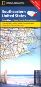
Southeastern USA
Southeastern USA on an overview road map from the National Geographic with 16 panels showing road access to main towns, street plans of central Washington DC and New Orleans, maps of main national parks, and general notes about the states covered by the map. The main map at approx. 1:3, 500, 000 shows extends south from Philadelphia and Pittsburg and west to the Mississippi, covering Southern Pennsylvania and Ohio, the Virginias, Kentucky, Tennessee, the Carolinas, Georgia, Alabama, Mississippi and Florida. The map shows the network of the interstate highways and connecting main roads and highlights national parks and various other places of interest. An enlargement presents the Washington – Baltimore area in greater detail, plus 16 more panels show main roads in and around:
Richmond plus Norfolk – Virginia Beach – Newport News VA, Charleston WV, Lexington and Louisville KY, Raleigh and Charlotte NC, Charleston SC, Savanna and Atlanta GA, Memphis and Nashville TN, Jackson MS, Birmingham AL, Orlando with Disney World, Tampa – St. Petersburg and the Miami – Fort Lauderdale – West Palm Beach in Florida. Street plan cover central DC plus the French Quarter of New Orleans. Also included are overview maps of Shenandoah, Great Smoky Mountains and Everglades National Parks. All are annotated with places of interest.
Richmond plus Norfolk – Virginia Beach – Newport News VA, Charleston WV, Lexington and Louisville KY, Raleigh and Charlotte NC, Charleston SC, Savanna and Atlanta GA, Memphis and Nashville TN, Jackson MS, Birmingham AL, Orlando with Disney World, Tampa – St. Petersburg and the Miami – Fort Lauderdale – West Palm Beach in Florida. Street plan cover central DC plus the French Quarter of New Orleans. Also included are overview maps of Shenandoah, Great Smoky Mountains and Everglades National Parks. All are annotated with places of interest.

Product Description
Reviews/Comments
Add New
Vouchers
No voucher codes found.
Do you know a voucher code for this product or supplier? Add it to Insights for others to use.
Do you know a voucher code for this product or supplier? Add it to Insights for others to use.
 Denmark